File:Karte Umfahrung der Schiersteiner Brücke.png
Jump to navigation
Jump to search

Size of this preview: 444 × 599 pixels. Other resolutions: 178 × 240 pixels | 356 × 480 pixels | 569 × 768 pixels | 759 × 1,024 pixels | 1,480 × 1,996 pixels.
Original file (1,480 × 1,996 pixels, file size: 328 KB, MIME type: image/png)
Captions
Captions
Add a one-line explanation of what this file represents
Summary[edit]
| Description |
|
| Date | see file history |
| Source | Own work |
| Author | Maximilian Dörrbecker (Chumwa) |
| Permission (Reusing this file) |
I, the copyright holder of this work, hereby publish it under the following license: This file is licensed under the Creative Commons Attribution-Share Alike 2.5 Generic license.
Sie dürfen das Bild zu den folgenden Bedingungen nutzen:
|
File history
Click on a date/time to view the file as it appeared at that time.
| Date/Time | Thumbnail | Dimensions | User | Comment | |
|---|---|---|---|---|---|
| current | 09:16, 1 February 2016 | | 1,480 × 1,996 (328 KB) | Kopiersperre (talk | contribs) | optipng |
| 05:59, 17 May 2015 |  | 1,480 × 1,996 (531 KB) | Chumwa (talk | contribs) | B8, B54, B260 und B455 ergänzt | |
| 04:41, 15 May 2015 |  | 1,480 × 1,996 (492 KB) | Chumwa (talk | contribs) | B420 ergänzt | |
| 04:33, 15 May 2015 |  | 1,480 × 1,996 (486 KB) | Chumwa (talk | contribs) | B9 südlich von Mainz nachgetragen; Theodor-Heuss-Brücke auf 7,5 t beschränkt | |
| 11:40, 11 May 2015 |  | 1,480 × 1,996 (471 KB) | Chumwa (talk | contribs) | corr | |
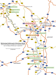
| 10:43, 11 May 2015 |  | 1,480 × 1,996 (471 KB) | Chumwa (talk | contribs) | {{Information |Description= *{{de|Karte der "Weiträumigen Umfahrung" der Schiersteiner Brücke zwischen Mainz und Wiesbaden während der Vollsperrung aufgrund von Brückenschäden vom 10. Februar 2105 bis zum 12. April 2015}} |Source={{own}} |Date=se... |
You cannot overwrite this file.
File usage on Commons
The following 10 pages use this file:
- User:Chumwa/Gallery
- User:Chumwa/OgreBot/Potential transport maps/2016 February 1-9
- User:Chumwa/OgreBot/Transport Maps/2015 May 11-20
- User:Chumwa/OgreBot/Transport Maps/2016 February 1-9
- User:Chumwa/OgreBot/Travel and communication maps/2016 February 1-9
- User:Pechristener/Bridges/2015 May 11-20
- User:SBT/Wiesbaden/2015 May 11-20
- User:SBT/Wiesbaden/2016 February 1-9
- User:Symposiarch/Mainz/2015 May 11-20
- User:Symposiarch/Mainz/2016 February 1-9
File usage on other wikis
The following other wikis use this file:
- Usage on de.wikipedia.org
- Usage on en.wikipedia.org
- Usage on fr.wikipedia.org