File:Karte S-Bahnnetze in Deutschland.svg
Jump to navigation
Jump to search

Size of this PNG preview of this SVG file: 428 × 599 pixels. Other resolutions: 171 × 240 pixels | 343 × 480 pixels | 549 × 768 pixels | 731 × 1,024 pixels | 1,463 × 2,048 pixels | 1,726 × 2,416 pixels.
Original file (SVG file, nominally 1,726 × 2,416 pixels, file size: 1.63 MB)
Captions
Captions
Add a one-line explanation of what this file represents
| Description |
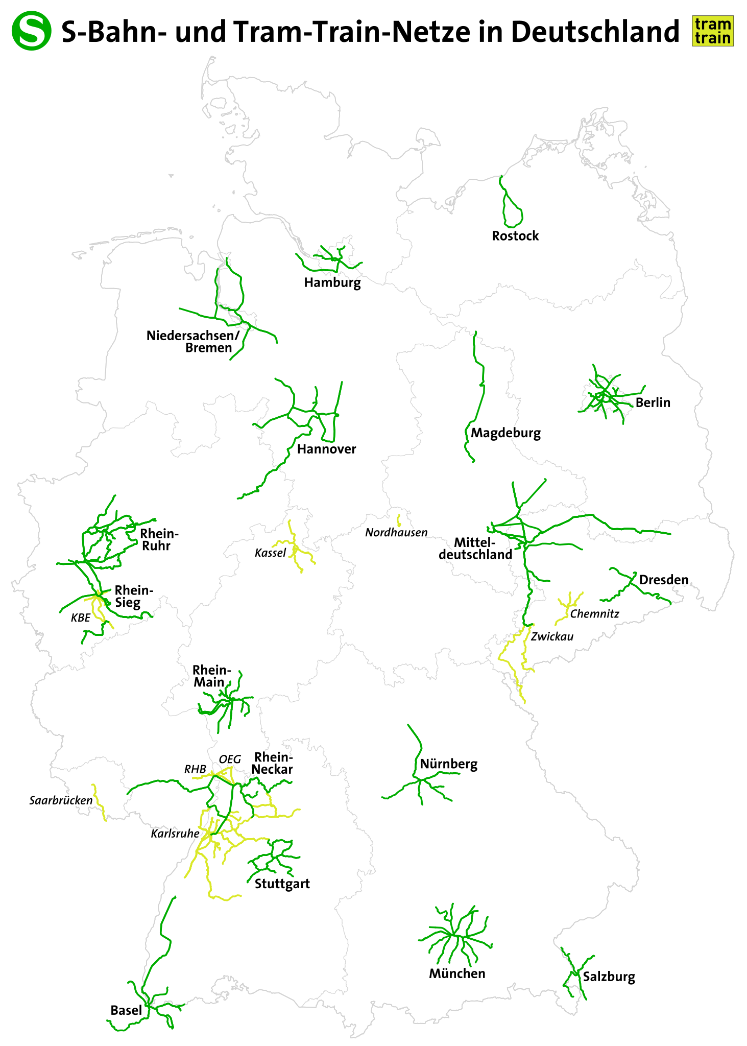
Deutsch:
S-Bahnnetze und Tram-Train-Netze in Deutschland English: S-Bahn routes in Germany |
|||
| Date | see file history | |||
| Source | Own work, using OpenStreetMap data | |||
| Author | Maximilian Dörrbecker (Chumwa) | |||
| Permission (Reusing this file) |
This file is licensed under the Creative Commons Attribution-Share Alike 2.0 Generic license.
|
|||
| Other versions |


File history
Click on a date/time to view the file as it appeared at that time.
| Date/Time | Thumbnail | Dimensions | User | Comment | |
|---|---|---|---|---|---|
| current | 21:08, 2 October 2022 | | 1,726 × 2,416 (1.63 MB) | Benfri (talk | contribs) | Reverted to version as of 20:16, 17 November 2018 (UTC) |
| 20:52, 2 October 2022 |  | 744 × 1,106 (7.68 MB) | Benfri (talk | contribs) | update | |
| 20:16, 17 November 2018 |  | 1,726 × 2,416 (1.63 MB) | Chumwa (talk | contribs) | update | |
| 21:06, 25 July 2016 |  | 1,726 × 2,416 (1.63 MB) | Chumwa (talk | contribs) | ||
| 20:47, 23 April 2016 |  | 1,726 × 2,416 (1.63 MB) | Chumwa (talk | contribs) | ||
| 17:37, 23 April 2016 |  | 1,726 × 2,416 (1.63 MB) | Chumwa (talk | contribs) | ||
| 22:47, 21 April 2016 |  | 998 × 1,320 (5.59 MB) | Chumwa (talk | contribs) | ||
| 21:44, 21 April 2016 |  | 998 × 1,320 (5.58 MB) | Chumwa (talk | contribs) | ||
| 17:54, 21 April 2016 |  | 998 × 1,320 (5.73 MB) | Chumwa (talk | contribs) | {{Information |Description = {{de|1=S-Bahnstrecken in Deutschland}} {{en|1=S-Bahn routes in Germany}} |Source={{own}}, using OpenStreetMap data |Date = see file history |Author = Maximilian Dörrbecker ([[:de:U... |
You cannot overwrite this file.
File usage on Commons
The following 53 pages use this file:
- User:Chumwa/Gallery
- User:Chumwa/OgreBot/Potential transport maps/2016 April 21-30
- User:Chumwa/OgreBot/Potential transport maps/2016 July 21-31
- User:Chumwa/OgreBot/Potential transport maps/2018 November 11-20
- User:Chumwa/OgreBot/Public transport information/2016 April 21-30
- User:Chumwa/OgreBot/Public transport information/2016 July 21-31
- User:Chumwa/OgreBot/Public transport information/2018 November 11-20
- User:Chumwa/OgreBot/Public transport information/2022 October 1-10
- User:Chumwa/OgreBot/Transport Maps/2016 April 21-30
- User:Chumwa/OgreBot/Transport Maps/2016 July 21-31
- User:Chumwa/OgreBot/Transport Maps/2018 November 11-20
- User:Chumwa/OgreBot/Transport Maps/2022 October 1-10
- User:Chumwa/OgreBot/Travel and communication maps/2016 April 21-30
- User:Chumwa/OgreBot/Travel and communication maps/2016 July 21-31
- User:Chumwa/OgreBot/Travel and communication maps/2018 November 11-20
- User:Chumwa/OtherVersions - OePNV-Karten
- File:Carte des transports urbains en France.png
- File:Dtl sbahn.svg
- File:Greater China Rapid Transit.svg
- File:Karte Metro-, Tram- und Obussysteme.svg
- File:Karte S-Bahnnetze in Deutschland.svg
- File:Karte der ÖPNV-Systeme in Deutschland 2008.png
- File:Karte der ÖPNV-Systeme in Lateinamerika.png
- File:Karte der ÖPNV-Systeme in Nordafrika.png
- File:Karte der ÖPNV-Systeme in Spanien und Portugal.png
- File:Karte der ÖPNV-Systeme in den Staaten der ehemaligen Sowjetunion.png
- File:Karte der ÖPNV-Systeme in den USA.png
- File:Karte ÖPNV-Netze Deutschland.svg
- File:Karte ÖPNV-Systeme in Italien.png
- File:Karte ÖPNV-Systeme in der Türkei.png
- File:Metro, tram a trolejbusy v ČR.jpg
- File:Metro map of China.svg
- File:Núcleos de Cercanías de Renfe.svg
- File:OePNVSystemeDeutschland.png
- File:OePNVSystemeDeutschlandJanuar2003.jpg
- File:OePNVSystemeFrankreich-fr.png
- File:OePNVSystemeFrankreich.png
- File:OePNVSystemeJapanJanuar2003.png
- File:OePNVSystemePolenMai2007.png
- File:Public transport system map of the USA.png
- File:Public transport systems of Italy.png
- File:Rail networks USA map.svg
- File:Réseaux de trolleybus en France.png
- File:S-Bahnen copy.svg (file redirect)
- File:Transports urbains de France.png
- File:Tranvía en España.svg
- File:ÖPNV-System in den Benelux-Staaten.png
- File:ÖPNV-Systeme Tschechische Republik.png
- File:ÖPNV-Systeme auf den Britischen Inseln.png
- File:ÖPNV-Systeme in China.png
- File:ÖPNV-Systeme in Korea.png
- File:ÖPNV-Systeme in Südosteuropa.png
- File:ÖPNV-Südkorea de.svg
File usage on other wikis
The following other wikis use this file:
- Usage on de.wikipedia.org
- Usage on en.wikipedia.org
- Usage on hu.wikipedia.org
- Usage on it.wikipedia.org
- Usage on ka.wikipedia.org
- Usage on ku.wikipedia.org
- Usage on ms.wikipedia.org
- Usage on no.wikipedia.org
- Usage on pl.wikipedia.org
- Usage on ru.wikipedia.org
- Usage on sk.wikipedia.org
- Usage on zh.wikipedia.org