File:Ith-Hils-Karte.png
Jump to navigation
Jump to search

Size of this preview: 630 × 600 pixels. Other resolutions: 252 × 240 pixels | 504 × 480 pixels | 840 × 800 pixels.
Original file (840 × 800 pixels, file size: 882 KB, MIME type: image/png)
Captions
Captions
Add a one-line explanation of what this file represents
| Description |
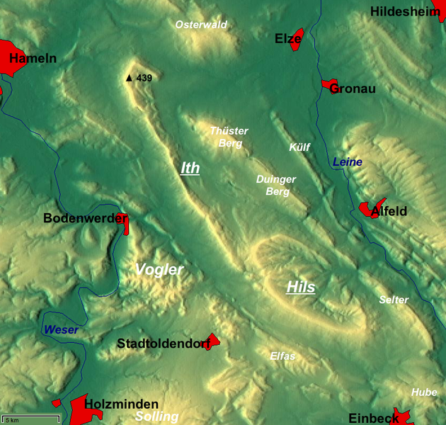
Deutsch: Weser-Leine-Bergland: Reliefkarte von Ith (mit Lauensteiner Kopf, 439 m) und Hils mit umgebenden Gebirgen/Höhenzügen; Niedersachsen, Deutschland. – Die Karte ist genordet, ein grober Maßstab ist unten links; zur Orientierung sind größere Städte und die beiden Flüsse Weser und Leine eingezeichnet. |
| Date | |
| Source |
English: relief map from maps-for-free.com including 2 layers "waterbodies" and "admin areas" – slightly reworked (names added etc.) |
| Author | Maps for Free (cropped/reworked by bdk) |
| Permission (Reusing this file) |
This file is licensed under the Creative Commons Attribution-Share Alike 3.0 Unported license.
|
| Other versions |
|


File history
Click on a date/time to view the file as it appeared at that time.
| Date/Time | Thumbnail | Dimensions | User | Comment | |
|---|---|---|---|---|---|
| current | 15:33, 8 April 2009 | | 840 × 800 (882 KB) | Mahahahaneapneap (talk | contribs) | Compressed |
| 04:38, 21 January 2008 |  | 840 × 800 (1.41 MB) | Bdk (talk | contribs) |
You cannot overwrite this file.
File usage on Commons
The following 5 pages use this file:
File usage on other wikis
The following other wikis use this file:
- Usage on arz.wikipedia.org
- Usage on de.wikipedia.org
- Usage on en.wikipedia.org
- Usage on mk.wikipedia.org
- Usage on nl.wikipedia.org
- Usage on sv.wikipedia.org
- Usage on www.wikidata.org