File:Israel and Judah Simplified.png
Jump to navigation
Jump to search

Size of this preview: 458 × 600 pixels. Other resolutions: 183 × 240 pixels | 494 × 647 pixels.
Original file (494 × 647 pixels, file size: 63 KB, MIME type: image/png)
Captions
Captions
Add a one-line explanation of what this file represents
Summary[edit]
| Description |
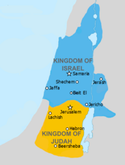
English: Simplified version of File:Kingdoms_of_Israel_and_Judah_map_830.svg with a few adjustments to letter formation. Estimated in the earlier file to be 830 BC. |
| Date | |
| Source | http://www.jewishvirtuallibrary.org/map-of-israel-and-judah-733-bce and File:Kingdoms_of_Israel_and_Judah_map_830.svg |
| Author | FinnWikiNo and Richardprins |
Licensing[edit]
This file is licensed under the Creative Commons Attribution-Share Alike 3.0 Unported license.
- You are free:
- to share – to copy, distribute and transmit the work
- to remix – to adapt the work
- Under the following conditions:
- attribution – You must give appropriate credit, provide a link to the license, and indicate if changes were made. You may do so in any reasonable manner, but not in any way that suggests the licensor endorses you or your use.
- share alike – If you remix, transform, or build upon the material, you must distribute your contributions under the same or compatible license as the original.
File history
Click on a date/time to view the file as it appeared at that time.
| Date/Time | Thumbnail | Dimensions | User | Comment | |
|---|---|---|---|---|---|
| current | 13:50, 27 April 2019 | | 494 × 647 (63 KB) | SelfieCity (talk | contribs) | Since the source mentioned in my previous upload was actually showing Judah in the 8th century BC, I'm moving Judah's boundary up north again a bit. Also removing a couple traces of the lighter shade of gray |
| 05:01, 27 April 2019 |  | 494 × 647 (64 KB) | SelfieCity (talk | contribs) | According to [https://www.jewishvirtuallibrary.org/map-of-israel-and-judah-733-bce one of my sources], Judah actually extended more to the south; I'm adjusting accordingly, and closely following their map | |
| 23:18, 26 April 2019 |  | 494 × 647 (57 KB) | SelfieCity (talk | contribs) | Well, I darkened the gray, anyway | |
| 22:42, 26 April 2019 |  | 494 × 647 (56 KB) | SelfieCity (talk | contribs) | Removed water border and made some boundaries "cleaner." If you have an issue seeing the water/land boundary (like if you're color blind), just let me know. Thanks! | |
| 22:17, 26 April 2019 |  | 494 × 647 (54 KB) | SelfieCity (talk | contribs) | Some more improvements: the border was removed to give the image clarity (the countries are slightly smaller as a result, but not much) and a couple text adjustments, border between land and sea adjustments, etc. were also made. If not stated before, I have been using GIMP to make these changes. | |
| 21:12, 26 April 2019 |  | 494 × 647 (60 KB) | SelfieCity (talk | contribs) | User created page with UploadWizard |
You cannot overwrite this file.
File usage on Commons
The following 28 pages use this file:
- File:Amón 830-es.svg
- File:Edom 830-es.svg
- File:Kingdoms around Israel 830 map-el.svg
- File:Kingdoms around Israel 830 map-nl.svg
- File:Kingdoms around Israel 830 map-pt.svg
- File:Kingdoms around Israel 830 map.svg
- File:Kingdoms around Israel 830 map mk.svg
- File:Kingdoms around Israel 830 map sh.svg
- File:Kingdoms around Israel 830 map sr.svg
- File:Kingdoms of Israel and Judah map 830-ar.svg
- File:Kingdoms of Israel and Judah map 830-el.svg
- File:Kingdoms of Israel and Judah map 830-es.svg
- File:Kingdoms of Israel and Judah map 830-hu.svg
- File:Kingdoms of Israel and Judah map 830-nl.svg
- File:Kingdoms of Israel and Judah map 830-pt.svg
- File:Kingdoms of Israel and Judah map 830.svg
- File:Kingdoms of Israel and Judah map 830 zh.svg
- File:Levant 830-HE-2.svg
- File:Levant 830-HE.svg
- File:Levant 830-rus.svg
- File:Levant 830.svg
- File:Levant 830 map-pt.svg
- File:Levant hu.svg
- File:Levante 830-es.svg
- File:Moab 830-es.svg
- File:Royaumes autour d'Israel en 830.svg
- File:イスラエル王国とユダ王国.svg
- Template:Other versions/Kingdoms around Israel 830 map