File:Ikweta ya anga.png
Jump to navigation
Jump to search
No higher resolution available.
Ikweta_ya_anga.png (756 × 590 pixels, file size: 211 KB, MIME type: image/png)
Captions
Captions
Add a one-line explanation of what this file represents
Summary[edit]
| Description |
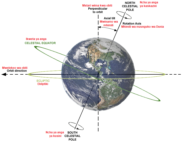
Kiswahili: Mistari ya anga: ikweta, ekliptiki
English: Description of relations between Axial tilt (or Obliquity), rotation axis, plane of orbit, celestial equator and ecliptic. Earth is shown as viewed from the Sun; the orbit direction is counter-clockwise (to the left). |
| Date | |
| Source | File:AxialTiltObliquity.png |
| Author | self-made by Dna-webmaster; earth-image from NASA |
| Other versions |
[]
|


Licensing[edit]
This file is licensed under the Creative Commons Attribution-Share Alike 4.0 International license.
- You are free:
- to share – to copy, distribute and transmit the work
- to remix – to adapt the work
- Under the following conditions:
- attribution – You must give appropriate credit, provide a link to the license, and indicate if changes were made. You may do so in any reasonable manner, but not in any way that suggests the licensor endorses you or your use.
- share alike – If you remix, transform, or build upon the material, you must distribute your contributions under the same or compatible license as the original.
File history
Click on a date/time to view the file as it appeared at that time.
| Date/Time | Thumbnail | Dimensions | User | Comment | |
|---|---|---|---|---|---|
| current | 23:27, 6 August 2017 | | 756 × 590 (211 KB) | Kipala (talk | contribs) | User created page with UploadWizard |
You cannot overwrite this file.
File usage on Commons
The following 16 pages use this file:
- File:Aksehældning.png
- File:AxialTiltObliquity-ar.png
- File:AxialTiltObliquity-az.png
- File:AxialTiltObliquity-pt.png
- File:AxialTiltObliquity-zh-Hans.png
- File:AxialTiltObliquity.png
- File:AxialTiltObliquity1-la.jpg
- File:AxialTiltObliquityFa.png
- File:AxialTiltObliquity mk.png
- File:Helling van de aardas.png
- File:Ikweta ya anga.png
- File:Maapallon akselit ja kallistuskulma.png
- File:Oblicuidad o Inclinación Axial de la Tierra.svg
- File:Obliquite plan ecliptique.png
- File:Obliqüitat o inclinació de l'eix de la Terra.svg
- Template:Other versions/AxialTiltObliquity
File usage on other wikis
The following other wikis use this file:
- Usage on sw.wikipedia.org