File:IguazuFallsAerial.jpg
Jump to navigation
Jump to search

Size of this preview: 800 × 600 pixels. Other resolutions: 320 × 240 pixels | 640 × 480 pixels | 1,024 × 768 pixels.
Original file (1,024 × 768 pixels, file size: 174 KB, MIME type: image/jpeg)
Captions
Captions
Add a one-line explanation of what this file represents
Summary[edit]
| Description |
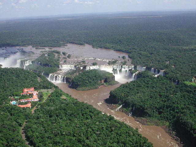
English: This view of the Iguazu Falls was captured from a helicopter in March of 2003. These falls are located on the Brazilian/Argentinian border in Iguazú National Park. The source of the Iguazu River is in the Santa Catarina province of southeastern Brazil. After flowing west-northwest for several hundred km, the Iguazu abruptly drops 80 m (260 ft), forming these picturesque waterfalls. Less than 50 km (30 miles) downstream, the Iguazu empties into the Paraná River. This photo shows the entire width of the Falls (approximately 3 km or 2 miles wide), the second widest waterfall in the world. Iguazu Falls, in Misiones (Argentina).
|
| Date | |
| Source | NIST photograph, from the February 17, 2004 Earth Science Picture of the Day (EPOD) (direct image URL [1]) |
| Author | Christopher Meyer |
| Permission (Reusing this file) |
Public domain |
![[1]](http://epod.usra.edu/archive/images/dscn1719.jpg)
Licensing[edit]
This image is in the public domain in the United States because it is a work of the United States Federal Government, specifically an employee of the National Institute of Standards and Technology, under the terms of Title 17, Chapter 1, Section 105 of the US Code.
|
File history
Click on a date/time to view the file as it appeared at that time.
| Date/Time | Thumbnail | Dimensions | User | Comment | |
|---|---|---|---|---|---|
| current | 16:47, 3 June 2007 | | 1,024 × 768 (174 KB) | Clindberg (talk | contribs) | ==Summary== {{Information |Description=This view of the en:Iguazu Falls was captured from a helicopter in March of 2003. These falls are located on the Brazilian/Argentinian border in en:Iguazú National Park. |
You cannot overwrite this file.
File usage on Commons
The following 2 pages use this file:
File usage on other wikis
The following other wikis use this file:
- Usage on ast.wikipedia.org
- Usage on ca.wikipedia.org
- Usage on de.wikipedia.org
- Usage on el.wikipedia.org
- Usage on es.wikipedia.org
- Usage on hu.wikipedia.org