File:Idrissides22.PNG
Jump to navigation
Jump to search

Size of this preview: 800 × 512 pixels. Other resolutions: 320 × 205 pixels | 640 × 410 pixels | 1,113 × 713 pixels.
Original file (1,113 × 713 pixels, file size: 47 KB, MIME type: image/png)
Captions
Captions
Add a one-line explanation of what this file represents
| Description | |
| Date | |
| Source | Own work |
| Author | Omar-Toons |
| Permission (Reusing this file) |
This file is licensed under the Creative Commons Attribution 1.0 Generic license.
|
| Other versions |
|
![[4]](http://www.lib.utexas.edu/maps/historical/shepherd/byzantine_empires_814.jpg)
.gif)
File history
Click on a date/time to view the file as it appeared at that time.
| Date/Time | Thumbnail | Dimensions | User | Comment | |
|---|---|---|---|---|---|
| current | 16:44, 25 December 2011 | | 1,113 × 713 (47 KB) | Omar-Toons (talk | contribs) | col. + crop |
| 03:21, 26 August 2011 |  | 1,276 × 854 (55 KB) | Omar-Toons (talk | contribs) | modif carte selon source ajoutée | |
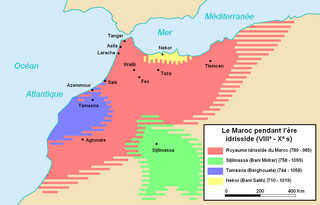
| 21:34, 9 May 2010 |  | 1,276 × 854 (54 KB) | Omar-Toons (talk | contribs) | {{Information |Description={{fr|1=Carte du Maroc pdt. l'ere idrisside. Travail basé essentiellement sur les cartes d'Euratlas [http://www.euratlas.net/history/europe/800/fr_800_sud-ouest.html][http://www.euratlas.net/history/europe/900/fr_900_sud-ouest. |
You cannot overwrite this file.
File usage on Commons
The following 3 pages use this file:
.gif)
File usage on other wikis
The following other wikis use this file:
- Usage on ar.wikipedia.org
- Usage on ba.wikipedia.org
- Usage on ca.wikipedia.org
- Usage on de.wikipedia.org
- Usage on en.wikipedia.org
- Usage on fr.wikipedia.org
- Ali ben Muhammad
- Émirat de Nekor
- Awerba
- Maroc
- Meknassas
- Histoire du Maroc
- Idrissides
- Discussion:Idrissides
- Algérie pendant le Moyen Âge
- Chérif
- Basra (Maroc)
- Utilisateur:Omar-toons/BàS/Grand Maroc
- Émirat de Sijilmassa
- Discussion Projet:Algérie/01.2014 -12.23.2015
- Utilisateur:105.143.12.164/Brouillon
- Discussion:Zirides/Archive 1
- Usage on hy.wikipedia.org
- Usage on it.wikipedia.org
- Usage on ja.wikipedia.org
- Usage on ru.wikipedia.org
- Usage on sl.wikipedia.org
- Usage on tt.wikipedia.org