File:IC 2007.gif
Jump to navigation
Jump to search

Size of this preview: 556 × 600 pixels. Other resolutions: 223 × 240 pixels | 600 × 647 pixels.
Original file (600 × 647 pixels, file size: 42 KB, MIME type: image/gif)
Captions
Captions
Add a one-line explanation of what this file represents
Summary[edit]
| Description |
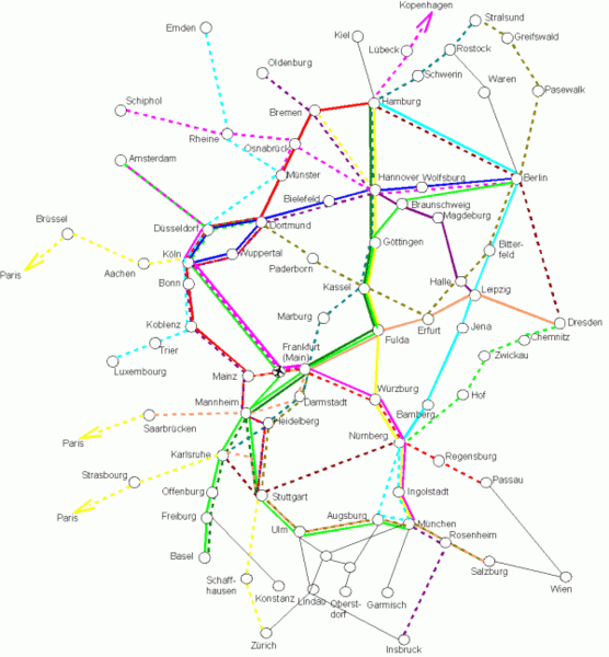
Lines of the German Intercity Train Network as of 2006/2007. Reconstructed using an official train time-table from that era, which was then available at http://www.bahn.de.
|
| Date | 8 January 2007 (original upload date) |
| Source | No machine-readable source provided. Own work assumed (based on copyright claims). |
| Author | No machine-readable author provided. Robert Will assumed (based on copyright claims). |
Licensing[edit]
| I, the copyright holder of this work, release this work into the public domain. This applies worldwide. In some countries this may not be legally possible; if so: I grant anyone the right to use this work for any purpose, without any conditions, unless such conditions are required by law. |
File history
Click on a date/time to view the file as it appeared at that time.
| Date/Time | Thumbnail | Dimensions | User | Comment | |
|---|---|---|---|---|---|
| current | 00:01, 8 January 2007 | | 600 × 647 (42 KB) | Robert Will (talk | contribs) | Lines of the German Intercity Train Network as of 2006/2007. Reconstructed using an official train time-table from that era, which was then available at http://www.bahn.de. * Each coloured line on the map corresponds to one train per hour on that line. D |
You cannot overwrite this file.
File usage on Commons
There are no pages that use this file.
File usage on other wikis
The following other wikis use this file:
- Usage on de.wikipedia.org
- Usage on ja.wikipedia.org