File:Hurricane-Tropical Storm - Conklin, N. Y. , September 14, 2011 -- Damages after remnants of Tropical Storm Lee passed through New York State on September 7, 2011. FEMA plays a vital - DPLA - 26e4111ec5f2a0a845831c79c15f17d5.jpg
Jump to navigation
Jump to search

Size of this preview: 800 × 531 pixels. Other resolutions: 320 × 213 pixels | 640 × 425 pixels | 1,024 × 680 pixels | 1,280 × 850 pixels | 3,000 × 1,993 pixels.
Original file (3,000 × 1,993 pixels, file size: 5.96 MB, MIME type: image/jpeg)
Captions
Captions
Add a one-line explanation of what this file represents
Summary[edit]
| Creator | Department of Homeland Security. Federal Emergency Management Agency. Public Affairs Division. 3/1/2003 | |||||||||||||||||||
| Title |
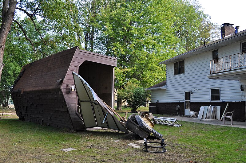
Hurricane/Tropical Storm - Conklin, N. Y. , September 14, 2011 -- Damages after remnants of Tropical Storm Lee passed through New York State on September 7, 2011. FEMA plays a vital role supporting State, Tribal and local governments as they respond to the impacts of remnants of Tropical Storm Lee. Photo by Elissa Jun/FEMA |
|||||||||||||||||||
| Description |
The original database describes this as: Title: Damages from Tropical Storm Lee Production Date: 09/14/2011 Caption: Conklin, N. Y. , September 14, 2011 -- Damages after remnants of Tropical Storm Lee passed through New York State on September 7, 2011. FEMA plays a vital role supporting State, Tribal and local governments as they respond to the impacts of remnants of Tropical Storm Lee. Photo by Elissa Jun/FEMA Photographer Name: Elissa Jun City/State: Conklin, NY Keywords: FEMA ^ Tropical Storm Lee ^ Flood ^ Broome ^ Binghamton ^ debris ^ conklin Disasters: New York Remnants of Tropical Storm Lee (EM-3341) ^ New York Remnants of Tropical Storm Lee (DR-4031) Disaster Types: Hurricane/Tropical Storm Categories: Debris |
|||||||||||||||||||
| Date | 14 September 2011 | |||||||||||||||||||
| Collection |
|
|||||||||||||||||||
| Source/Photographer |
|
|||||||||||||||||||
| Permission (Reusing this file) |
|
|||||||||||||||||||
| Standardized rights statement |
|
|||||||||||||||||||
| Camera location | | View this and other nearby images on: OpenStreetMap |
|---|
File history
Click on a date/time to view the file as it appeared at that time.
| Date/Time | Thumbnail | Dimensions | User | Comment | |
|---|---|---|---|---|---|
| current | 04:52, 23 November 2020 | | 3,000 × 1,993 (5.96 MB) | DPLA bot (talk | contribs) | Uploading DPLA ID 26e4111ec5f2a0a845831c79c15f17d5 |
You cannot overwrite this file.
File usage on Commons
The following page uses this file: