File:Heiankyo palace location.png
Jump to navigation
Jump to search

Size of this preview: 550 × 600 pixels. Other resolutions: 220 × 240 pixels | 440 × 480 pixels | 910 × 992 pixels.
Original file (910 × 992 pixels, file size: 225 KB, MIME type: image/png)
Captions
Captions
Add a one-line explanation of what this file represents

|
This architecture image could be re-created using vector graphics as an SVG file. This has several advantages; see Commons:Media for cleanup for more information. If an SVG form of this image is available, please upload it and afterwards replace this template with
{{vector version available|new image name}}.
It is recommended to name the SVG file “Heiankyo palace location.svg”—then the template Vector version available (or Vva) does not need the new image name parameter. |
Summary[edit]
| Description |
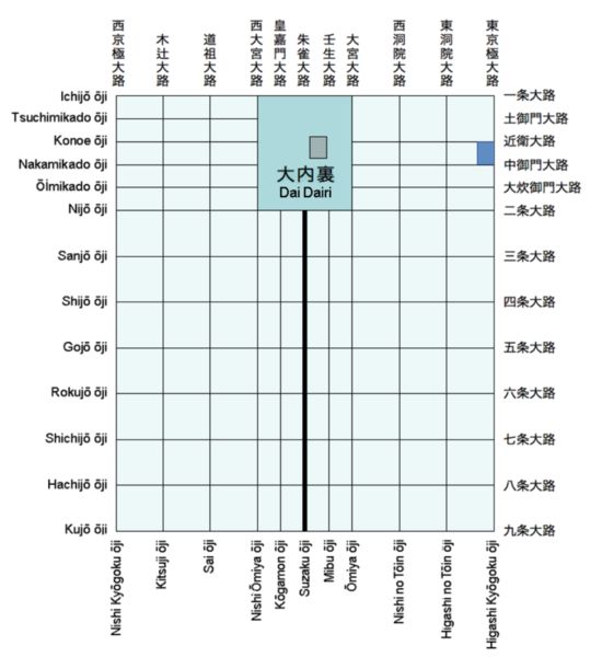
English: Schematic map of historical Heian-kyō (present-day Kyoto) showing the location of the Greater Imperial Palace (Daidairi) and the Tsuchimikado mansion.
Transferred from en.wikipedia to Commons. |
| Date | 19 May 2007 (original upload date) |
| Source |
Own work using:
|
| Author | Stca74 at English Wikipedia |
Licensing[edit]
| This work has been released into the public domain by its author, Stca74 at English Wikipedia. This applies worldwide. In some countries this may not be legally possible; if so: Stca74 grants anyone the right to use this work for any purpose, without any conditions, unless such conditions are required by law. |
Original upload log[edit]
The original description page was here. All following user names refer to en.wikipedia.
- 2007-05-19 09:17 Stca74 960×945×4 (9424 bytes) Schematic map of historical Heian-kyō (present-day Kyoto)showing the location of the Greater Imperial Palace (Daidairi) and the Tsuchimikado mansion. [[Category:Maps of the history of Japan]]
File history
Click on a date/time to view the file as it appeared at that time.
| Date/Time | Thumbnail | Dimensions | User | Comment | |
|---|---|---|---|---|---|
| current | 02:19, 11 February 2023 | | 910 × 992 (225 KB) | Firefangledfeathers (talk | contribs) | Cropped 23 % vertically using CropTool with precise mode. |
| 10:56, 29 October 2022 |  | 910 × 1,286 (274 KB) | Stca74 (talk | contribs) | Fixed modern palace location that had been lost in previous edit | |
| 01:29, 8 January 2019 |  | 784 × 886 (114 KB) | 白拍子花子 (talk | contribs) | Corrected typo and refined typography | |
| 14:22, 31 May 2007 |  | 960 × 945 (9 KB) | うぃき野郎 (talk | contribs) | {{Information |Description=Schematic map of historical Heian-kyō (present-day Kyoto)showing the location of the Greater Imperial Palace (Daidairi) and the Tsuchimikado mansion. en:Category:Maps of the history of Japan |Source=Originally from [http: |
You cannot overwrite this file.
File usage on Commons
The following 2 pages use this file:
File usage on other wikis
The following other wikis use this file:
- Usage on ca.wikipedia.org
- Usage on cs.wikipedia.org
- Usage on de.wikipedia.org
- Usage on en.wikipedia.org
- Usage on es.wikipedia.org
- Usage on fi.wikipedia.org
- Usage on fr.wikipedia.org
- Usage on hu.wikipedia.org
- Usage on id.wikipedia.org
- Usage on ja.wikipedia.org
- Usage on ms.wikipedia.org
- Usage on pl.wikipedia.org
- Usage on pt.wikipedia.org
- Usage on ru.wikipedia.org
- Usage on sl.wikipedia.org
- Usage on th.wikipedia.org
- Usage on tr.wikipedia.org
- Usage on vi.wikipedia.org
- Usage on zh.wikipedia.org