File:Hallandsåstunneln OSM zoom 11 slim.png
Jump to navigation
Jump to search
No higher resolution available.
Hallandsåstunneln_OSM_zoom_11_slim.png (300 × 360 pixels, file size: 112 KB, MIME type: image/png)
Captions
Captions
Add a one-line explanation of what this file represents
| Description |
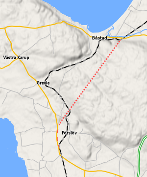
Map of the area around Hallandsåstunneln in Sweden. The dotted red line is the tunnel and the dashed red line is the connecting railway. This map was created from OpenStreetMap project data, collected by the community. This map may be incomplete, and may contain errors. Don't rely solely on it for navigation. |
| Date | |
| Source | openstreetmap.org |
| Creator |
Map data: OpenStreetMap contributors, rendering: Erik Lundin. OpenStreetMap contributors |
| Permission (Reusing this file) |
OpenStreetMap data and maps are licensed under the Creative Commons Attribution-ShareAlike 2.0 license (CC-BY-SA 2.0). This file is licensed under the Creative Commons Attribution-Share Alike 2.0 Generic license.
|
| Georeferencing | If inappropriate please set warp_status = skip to hide. |
| Other versions |
This is a cropped version of File:Hallandsåstunneln_OSM_zoom_11.png. Slippy map at openstreetmap.org |
File history
Click on a date/time to view the file as it appeared at that time.
| Date/Time | Thumbnail | Dimensions | User | Comment | |
|---|---|---|---|---|---|
| current | 02:09, 6 January 2012 | | 300 × 360 (112 KB) | Luen (talk | contribs) | {{OpenStreetMap |description=Map of the area around Hallandsåstunneln in Sweden. The dotted red line is the tunnel and the dashed red line is the connecting railway. |authors=Map data: OpenStreetMap contributors, rendering: Erik Lundin. |da |
You cannot overwrite this file.
File usage on Commons
The following page uses this file:
File usage on other wikis
The following other wikis use this file:
- Usage on da.wikipedia.org
- Usage on no.wikipedia.org
- Usage on pt.wikipedia.org
- Usage on sv.wikipedia.org