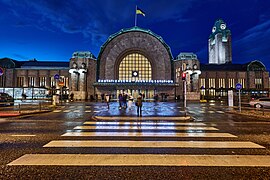
File:Half-empty interior of the Central Station in Helsinki, Finland during the COVID-19 pandemic, 2020 April.jpg
From Wikimedia Commons, the free media repository
Jump to navigation
Jump to search

Size of this preview: 800 × 533 pixels. Other resolutions: 320 × 213 pixels | 640 × 427 pixels | 1,024 × 683 pixels | 1,280 × 853 pixels | 2,560 × 1,707 pixels | 8,256 × 5,504 pixels.
Original file (8,256 × 5,504 pixels, file size: 11.2 MB, MIME type: image/jpeg)
File information
Structured data
Captions
Captions
Add a one-line explanation of what this file represents
Summary[edit]
| Eliel Saarinen: Helsinki Central Railway Station
|
|||||||||||||||||||||||||||
|---|---|---|---|---|---|---|---|---|---|---|---|---|---|---|---|---|---|---|---|---|---|---|---|---|---|---|---|
| Architect |
|
||||||||||||||||||||||||||
| Photographer |
Yehia Eweis |
||||||||||||||||||||||||||
| Title |
Half-empty interior of the Central Station in Helsinki, Finland during the COVID-19 pandemic, 2020 April |
||||||||||||||||||||||||||
| Part of |
Helsinki Railway Square |
||||||||||||||||||||||||||
| Object type |
station building / central station / architectural landmark / station located on surface / dead-end railway station |
||||||||||||||||||||||||||
| Description |
English: The Central railway station being rather quiet during the COVID-19 pandemic. On a regular afternoon the place would be as busy as it gets.
Suomi: Koronapandemian poikkeusolot jatkuvat kolmatta viikkoa, eikä Helsingin päärautatieaseman asemahallissa näy iltapäiväruuhkaa. |
||||||||||||||||||||||||||
| Depicted place | Central Station in Helsinki, Finland | ||||||||||||||||||||||||||
| Date | 1 April 2020 | ||||||||||||||||||||||||||
| Collection |
institution QS:P195,Q2031357 |
||||||||||||||||||||||||||
| Accession number |
G26084 |
||||||||||||||||||||||||||
| Object location |
|
||||||||||||||||||||||||||
| Source | Finna: Koronapandemian poikkeusolot jatkuvat kolmatta viikkoa, eikä Helsingin päärautatieaseman asemahallissa näy totuttua iltapäiväruuhkaa | ||||||||||||||||||||||||||
| Permission (Reusing this file) |
CC BY 4.0 | ||||||||||||||||||||||||||
| Other versions |
|
||||||||||||||||||||||||||
| Camera location | 60° 10′ 16.27″ N, 24° 56′ 28.99″ E | View this and other nearby images on: OpenStreetMap |
|---|
Licensing[edit]
This file is licensed under the Creative Commons Attribution 4.0 International license.
- You are free:
- to share – to copy, distribute and transmit the work
- to remix – to adapt the work
- Under the following conditions:
- attribution – You must give appropriate credit, provide a link to the license, and indicate if changes were made. You may do so in any reasonable manner, but not in any way that suggests the licensor endorses you or your use.
This file is digitized and shared in Wikimedia Commons by the Helsinki City Museum. This tag does not indicate the copyright status of the attached work. A normal copyright tag is still required. See Commons:Licensing. English | suomi | македонски | polski | русский | svenska | +/− |
File history
Click on a date/time to view the file as it appeared at that time.
| Date/Time | Thumbnail | Dimensions | User | Comment | |
|---|---|---|---|---|---|
| current | 11:59, 23 August 2021 |  | 8,256 × 5,504 (11.2 MB) | Coen (talk | contribs) | Uploaded a work by Yehia Eweis from https://finna.fi/Record/hkm.HKMS000005:km0000q5bs with UploadWizard |
You cannot overwrite this file.
File usage on Commons
The following 3 pages use this file:
Metadata
This file contains additional information such as Exif metadata which may have been added by the digital camera, scanner, or software program used to create or digitize it. If the file has been modified from its original state, some details such as the timestamp may not fully reflect those of the original file. The timestamp is only as accurate as the clock in the camera, and it may be completely wrong.
| Author | Eweis Yehia |
|---|---|
| Short title | 202018 . G26084 |
| City shown | Kaivokatu 1 . Helsinki. |
| Source | km0000q5bs |
| Copyright holder | Helsingin kaupunginmuseo |
| Image title | 20200401 . Koronapandemian poikkeusolot jatkuvat kolmatta viikkoa, eikä Helsingin päärautatieaseman asemahallissa näy totuttua iltapäiväruuhkaa. Nainen oikealla Hesburgerin edessä kaataa käsidesiä miehen kämmenelle. |
| Horizontal resolution | 300 dpi |
| Vertical resolution | 300 dpi |
| Y and C positioning | Centered |
| Province or state shown | Kluuvi |
| IIM version | 4 |
Structured data
Items portrayed in this file
depicts
60°10'16.266"N, 24°56'28.993"E
1 April 2020
60°10'15.77395"N, 24°56'29.21546"E
8d7a2a0a6ad87637
b97236b1f2f2f0f0
Hidden categories:
- Files with coordinates missing SDC location of creation
- Artworks with main subject missing same depicts
- Photographs with Wikidata item
- Photographs with Wikidata item missing accession number
- Photographs with Wikidata item: quick statements
- Artworks main subject type unknown type of work
- CC-BY-4.0
- Files from the Helsinki City Museum
- Finland photographs taken on 2020-04-01
- Pages with maps


