File:Guantánamo Province Location.png
Jump to navigation
Jump to search
Size of this preview: 800 × 306 pixels. Other resolutions: 320 × 123 pixels | 1,068 × 409 pixels.
Original file (1,068 × 409 pixels, file size: 178 KB, MIME type: image/png)
Captions
Captions
Add a one-line explanation of what this file represents

|
This locator map image could be re-created using vector graphics as an SVG file. This has several advantages; see Commons:Media for cleanup for more information. If an SVG form of this image is available, please upload it and afterwards replace this template with
{{vector version available|new image name}}.
It is recommended to name the SVG file “Guantánamo Province Location.svg”—then the template Vector version available (or Vva) does not need the new image name parameter. |
Summary[edit]
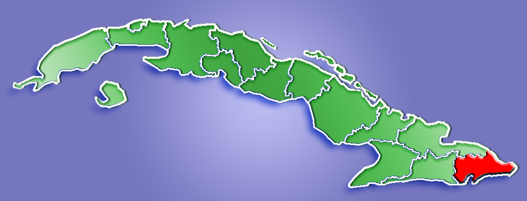
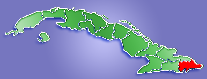
Location of Guantánamo Province, Cuba
Licensing[edit]
| I, the copyright holder of this work, release this work into the public domain. This applies worldwide. In some countries this may not be legally possible; if so: I grant anyone the right to use this work for any purpose, without any conditions, unless such conditions are required by law. |
File history
Click on a date/time to view the file as it appeared at that time.
| Date/Time | Thumbnail | Dimensions | User | Comment | |
|---|---|---|---|---|---|
| current | 13:06, 22 May 2006 | 1,068 × 409 (178 KB) | Qyd (talk | contribs) | ||
| 23:21, 16 March 2006 | 1,068 × 409 (21 KB) | Qyd (talk | contribs) | Location of Guantánamo Province, Cuba Category:Province Maps of Cuba |
You cannot overwrite this file.
File usage on Commons
The following 2 pages use this file:
File usage on other wikis
The following other wikis use this file:
- Usage on ceb.wikipedia.org
- Usage on ht.wikipedia.org
- Achotal, Guantanamo
- Agapito, Guantanamo
- Aguada de Bueyes, Guantanamo
- Aguanta, Guantanamo
- Alto del Mango, Guantanamo
- Aqua La Bella, Guantanamo
- Arena, Guantanamo
- Arenal, Guantanamo
- Argeo Martinez, Guantanamo
- Argeo Martínez, Guantanamo
- Arroyo Blanco, Guantanamo
- Arroyo Hondo, Guantanamo
- Arroyo Negro, Guantanamo
- Avispero, Guantanamo
- Baire, Guantanamo
- Baitiquirí, Guantanamo
- Baitiqurí, Guantanamo
- Baldor, Guantanamo
- Barigua, Guantanamo
- Bariguarita, Guantanamo
- Bariguá, Guantanamo
- Batea, Guantanamo
- Batey Durano, Guantanamo
- Batey S, Emilio, Guantanamo
- Bayate, Guantanamo
- Bayates, Guantanamo
- Bella Vista, Guantanamo
- Belona, Guantanamo
- Bernardo, Guantanamo
- Bilorio, Guantanamo
- Boca de Quibiján, Guantanamo
- Boca de Tánamo, Guantanamo
- Boca de Yumurí, Guantanamo
- Boma, Guantanamo
- Boquerón, Guantanamo
- Boruga, Guantanamo
- Brazo Seco, Guantanamo
- Buena Vista, Guantanamo
- Buenavista, Guantanamo
- Bueycabon, Guantanamo
- Bueycabón, Guantanamo
- Cabacú, Guantanamo
- Cabañas, Guantanamo
- Cabeza de Vaca, Guantanamo
- Caguairan Blanco, Guantanamo
- Cagüinas, Guantanamo
- Cajobabo, Guantanamo
- Calalina, Guantanamo
- Camarones, Guantanamo
View more global usage of this file.