File:Giacomo Cantelli and Domenico De Rossi. TERRA SANCTA. 1677-1688.jpg
Jump to navigation
Jump to search
Size of this preview: 758 × 599 pixels. Other resolutions: 304 × 240 pixels | 607 × 480 pixels | 856 × 677 pixels.
Original file (856 × 677 pixels, file size: 242 KB, MIME type: image/jpeg)
Captions
Captions
Add a one-line explanation of what this file represents
Summary
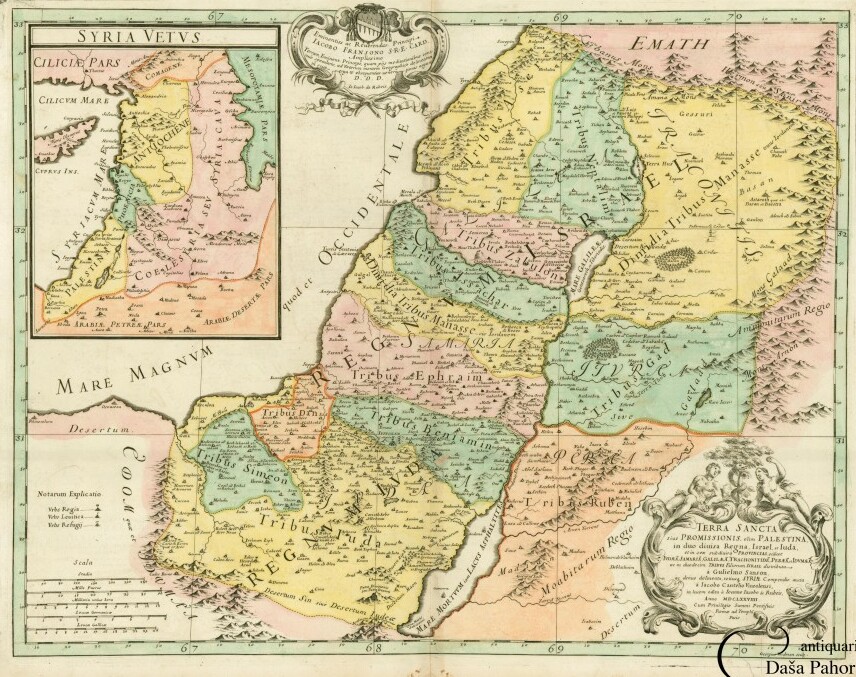
[edit]| Latina: TERRA SANCTA SIUE PROMISSIONIS, OLIM PALESTINA, IN DUO DIVISA REGNA, ISRAEL, ET LUDA, ET IN SEX SUBDIVISA PROVINCIAS SCILICET IUDAE, SAMARIA, GALILEA, TRACHONITIDE, PERAEA... | |||||||||||||||||||||||||||||||||||||||||||
|---|---|---|---|---|---|---|---|---|---|---|---|---|---|---|---|---|---|---|---|---|---|---|---|---|---|---|---|---|---|---|---|---|---|---|---|---|---|---|---|---|---|---|---|
| Artist |
|
||||||||||||||||||||||||||||||||||||||||||
| Title |
Latina: TERRA SANCTA SIUE PROMISSIONIS, OLIM PALESTINA, IN DUO DIVISA REGNA, ISRAEL, ET LUDA, ET IN SEX SUBDIVISA PROVINCIAS SCILICET IUDAE, SAMARIA, GALILEA, TRACHONITIDE, PERAEA... |
||||||||||||||||||||||||||||||||||||||||||
| Description |
English: Detailed map of the Holy Land shows the Kingdoms of Judah and Israel. The in-set map showcases ancient Syria with Cyprus on the left-hand side. The map was made by an Italian cartographer Giacomo Cantelli da Vignola (1643-1695), active in Modena, and was based on a map by a French royal cartographer Nicolas Sanson. It was published in an Italian Atlas Il Mercurio geografico by Giovanni Giacomo de Rossi (1627-1691). The map was dedicated to the cardinal Jacopo Fransono. |
||||||||||||||||||||||||||||||||||||||||||
| Date | from 1677 until 1688 | ||||||||||||||||||||||||||||||||||||||||||
| Medium |
English: Coloured copper engraving (slightly stained in white margins. |
||||||||||||||||||||||||||||||||||||||||||
| Dimensions | height: 42 cm (16.5 in); width: 54.5 cm (21.4 in) | ||||||||||||||||||||||||||||||||||||||||||
| Place of creation | Rome | ||||||||||||||||||||||||||||||||||||||||||
| Source/Photographer | www.pahor.de | ||||||||||||||||||||||||||||||||||||||||||

Licensing
[edit]
|
This is a faithful photographic reproduction of a two-dimensional, public domain work of art. The work of art itself is in the public domain for the following reason:
The official position taken by the Wikimedia Foundation is that "faithful reproductions of two-dimensional public domain works of art are public domain".
This photographic reproduction is therefore also considered to be in the public domain in the United States. In other jurisdictions, re-use of this content may be restricted; see Reuse of PD-Art photographs for details. | ||||
File history
Click on a date/time to view the file as it appeared at that time.
| Date/Time | Thumbnail | Dimensions | User | Comment | |
|---|---|---|---|---|---|
| current | 20:21, 12 February 2023 | | 856 × 677 (242 KB) | Geagea (talk | contribs) | Cropped 16 % horizontally, 3 % vertically using CropTool with lossless mode. |
| 06:46, 30 November 2015 |  | 1,024 × 700 (255 KB) | Geagea (talk | contribs) | Transferred from http://www.pahor.de/media/catalog/product/cache/1/image/1024x700/9df78eab33525d08d6e5fb8d27136e95/6/2/62899.jpg |
You cannot overwrite this file.
File usage on Commons
The following 2 pages use this file: