File:Georgia administrative map-ru.svg
Jump to navigation
Jump to search

Size of this PNG preview of this SVG file: 707 × 385 pixels. Other resolutions: 320 × 174 pixels | 640 × 349 pixels | 1,024 × 558 pixels | 1,280 × 697 pixels | 2,560 × 1,394 pixels.
Original file (SVG file, nominally 707 × 385 pixels, file size: 1.08 MB)
Captions
Captions
Add a one-line explanation of what this file represents
| Description |
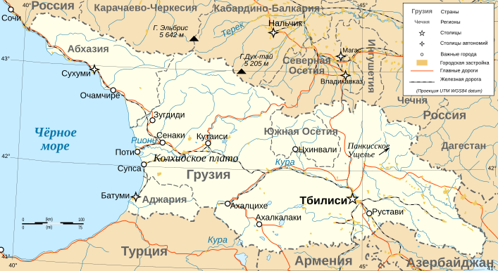
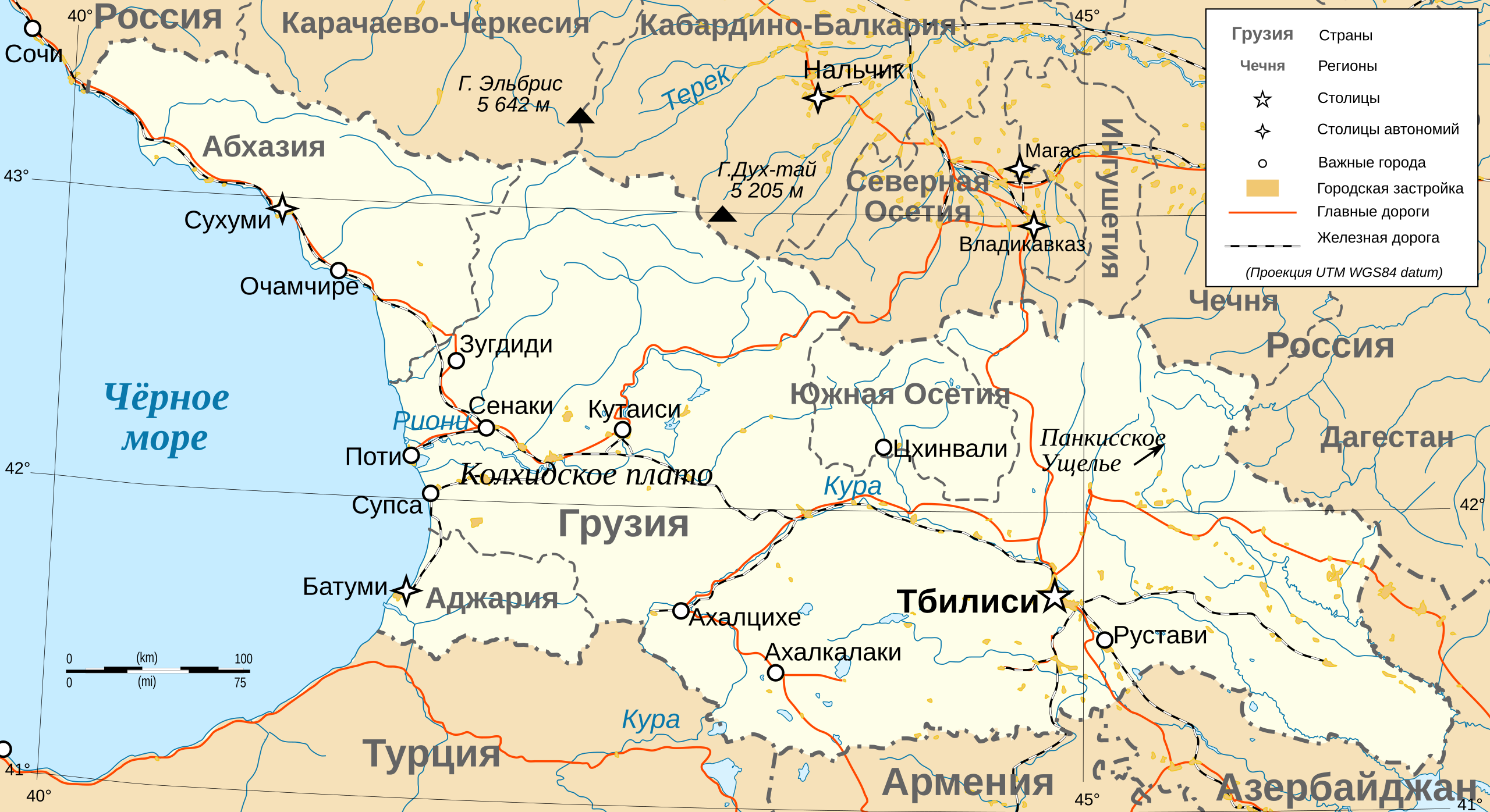
Deutsch: Karte von Georgien, französische Version English: Administrative map in French of Georgia Français : Carte administrative en français de la Géorgie |
| Date | (UTC) |
| Source | |
| Author |
|
| This is a retouched picture, which means that it has been digitally altered from its original version. Modifications: Translated. The original can be viewed here: Georgia administrative map-fr.svg:
|
I, the copyright holder of this work, hereby publish it under the following licenses:
This file is licensed under the Creative Commons Attribution-Share Alike 3.0 Unported, 2.5 Generic, 2.0 Generic and 1.0 Generic license.
- You are free:
- to share – to copy, distribute and transmit the work
- to remix – to adapt the work
- Under the following conditions:
- attribution – You must give appropriate credit, provide a link to the license, and indicate if changes were made. You may do so in any reasonable manner, but not in any way that suggests the licensor endorses you or your use.
- share alike – If you remix, transform, or build upon the material, you must distribute your contributions under the same or compatible license as the original.

|
Permission is granted to copy, distribute and/or modify this document under the terms of the GNU Free Documentation License, Version 1.2 or any later version published by the Free Software Foundation; with no Invariant Sections, no Front-Cover Texts, and no Back-Cover Texts. A copy of the license is included in the section entitled GNU Free Documentation License. |
You may select the license of your choice.
Original upload log[edit]
This image is a derivative work of the following images:
- File:Georgia_administrative_map-fr.svg licensed with Cc-by-sa-3.0,2.5,2.0,1.0, GFDL
- 2009-03-30T21:45:24Z Bourrichon 707x385 (1199126 Bytes) +Daguestan
- 2009-03-13T18:08:33Z Bourrichon 707x385 (1197450 Bytes) +longitude
- 2009-03-13T18:02:31Z Bourrichon 707x385 (1195403 Bytes) -Iran
- 2009-03-13T17:44:11Z Bourrichon 707x385 (1196026 Bytes) == Summary == {{Information |Description={{de|Karte von [[:de:Georgien|Georgien]], französische Version}}{{en|Administrative map in French of [[:en:Georgia|Georgia]]}}{{fr|Carte administrative en français de la [[:fr:Géorg
Uploaded with derivativeFX
File history
Click on a date/time to view the file as it appeared at that time.
| Date/Time | Thumbnail | Dimensions | User | Comment | |
|---|---|---|---|---|---|
| current | 11:57, 12 November 2009 | | 707 × 385 (1.08 MB) | DerFuchs (talk | contribs) | corrected name |
| 11:56, 12 November 2009 |  | 707 × 385 (1.08 MB) | DerFuchs (talk | contribs) | minor |
You cannot overwrite this file.
File usage on Commons
The following 2 pages use this file: