File:Gaza Strip map el.svg
Jump to navigation
Jump to search

Size of this PNG preview of this SVG file: 555 × 599 pixels. Other resolutions: 222 × 240 pixels | 444 × 480 pixels | 711 × 768 pixels | 948 × 1,024 pixels | 1,897 × 2,048 pixels | 839 × 906 pixels.
Original file (SVG file, nominally 839 × 906 pixels, file size: 159 KB)
Captions
Captions
Add a one-line explanation of what this file represents
| Description |
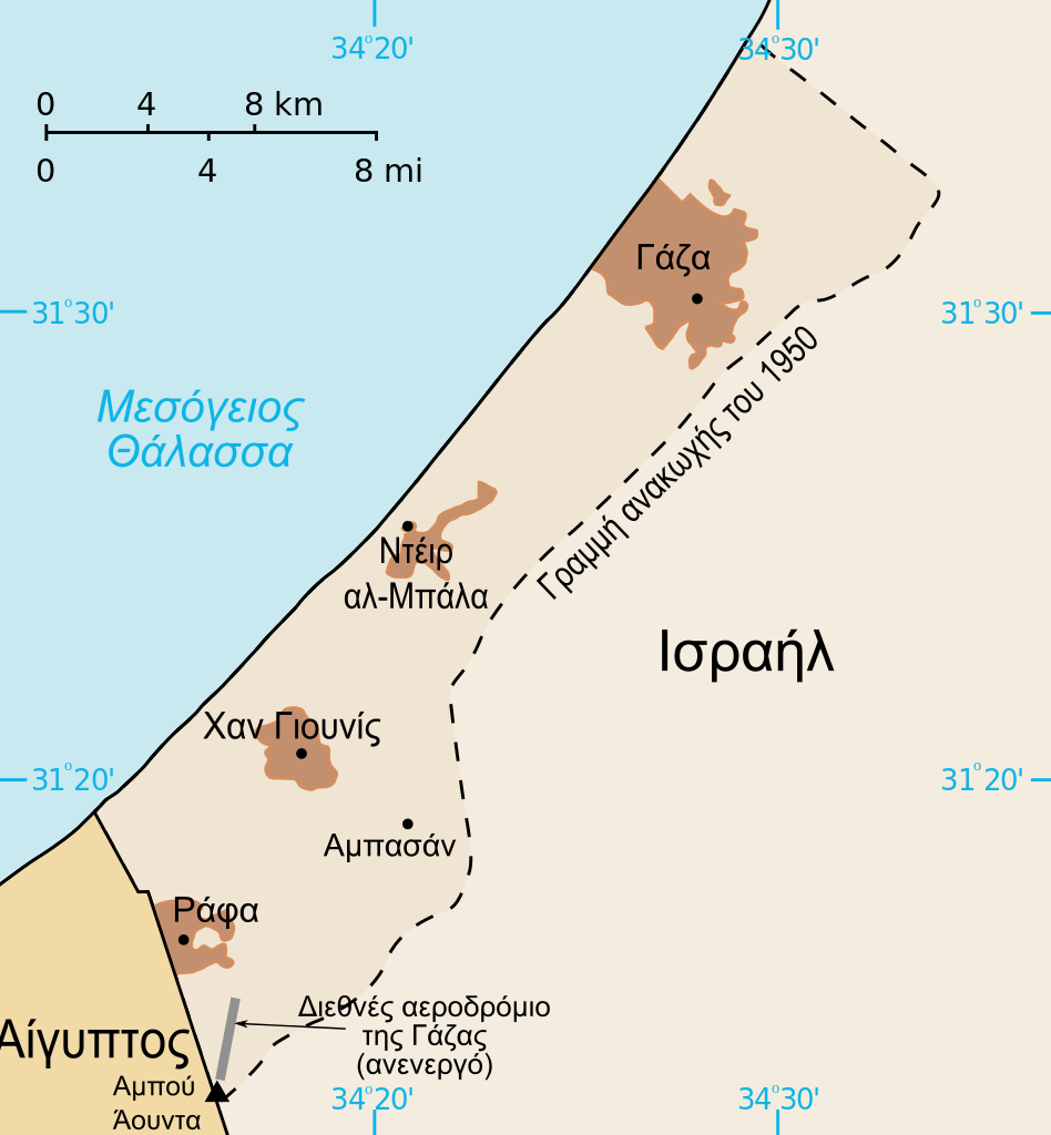
[] Bahasa Indonesia: Peta Jalur Gaza menunjukkan kota-kota utama dan negara-negara tetangga. Deutsch: Gazastreifen, urspr. English: A map of the Gaza Strip showing key towns and neighbouring countries. Español: Mapa de la Franja de Gaza Français : Carte de la bande de Gaza Norsk bokmål: Kart over Gazastripen Türkçe: Gazze Şeridi haritası, önemli kentler ve komşu ülkeler gösteriliyor. Ελληνικά: Χάρτης της Λωρίδας της Γάζας με τις κύριες πόλεις και τις γειτονικές χώρες Кыргызча: Газа тилкесинин картасы 中文(繁體): 加沙地帶(或稱加薩走廊)地圖 العربية : خارطة قطاع غزة A map of the en:Gaza Strip showing key towns and neighbouring countries. |
| Date | (UTC) |
| Source | |
| Author |
|
| Other versions |
[] Ver1:
Ver2:
|


| Raster versions | |
|---|---|
| PNG: | 800x864 pixels |
I, the copyright holder of this work, hereby publish it under the following licenses:
This file is licensed under the Creative Commons Attribution 2.5 Generic license.
- You are free:
- to share – to copy, distribute and transmit the work
- to remix – to adapt the work
- Under the following conditions:
- attribution – You must give appropriate credit, provide a link to the license, and indicate if changes were made. You may do so in any reasonable manner, but not in any way that suggests the licensor endorses you or your use.

|
Permission is granted to copy, distribute and/or modify this document under the terms of the GNU Free Documentation License, Version 1.2 or any later version published by the Free Software Foundation; with no Invariant Sections, no Front-Cover Texts, and no Back-Cover Texts. A copy of the license is included in the section entitled GNU Free Documentation License. |
| This file is licensed under the Creative Commons Attribution-Share Alike 3.0 Unported license. | ||
| ||
| This licensing tag was added to this file as part of the GFDL licensing update. |
You may select the license of your choice.
Original upload log[edit]
This image is a derivative work of the following images:
- Image:Gaza_Strip_map_blank.svg licensed with Cc-by-2.5, Cc-by-2.5/en, GFDL, GFDL/en
- 2007-02-16T09:45:04Z Masur 839x906 (43004 Bytes) {{Information |Description=based on [[:Image:Gaza Strip map.svg]]:"A map of the [[:en:Gaza Strip]] showing key towns and neighbouring countries. Blank version. Taken from [[CIA World Factbook]] website on 12 April. [[Public
Uploaded with derivativeFX
File history
Click on a date/time to view the file as it appeared at that time.
| Date/Time | Thumbnail | Dimensions | User | Comment | |
|---|---|---|---|---|---|
| current | 13:37, 13 January 2009 | | 839 × 906 (159 KB) | Geraki (talk | contribs) | corrections on translated names |
| 10:44, 28 December 2008 |  | 839 × 906 (157 KB) | Geraki (talk | contribs) | Text to path | |
| 10:39, 28 December 2008 |  | 839 × 906 (49 KB) | Geraki (talk | contribs) | {{Information |Description={{el|Χάρτης της Λωρίδας της Γάζας.}} Based on Image:Gaza Strip map.svg:"<br>A map of the en:Gaza Strip showing key towns and neighbouring countries. Blank |
You cannot overwrite this file.
File usage on Commons
The following 34 pages use this file:
- File:Gaza Strip el.svg
- File:Gaza Strip map-hu.svg
- File:Gaza Strip map-ru.svg
- File:Gaza Strip map.png
- File:Gaza Strip map.svg
- File:Gaza Strip map2-ar1.svg
- File:Gaza Strip map2.svg
- File:Gaza Strip map2 hr.svg
- File:Gaza Strip map2 id.svg
- File:Gaza Strip map2 ko.svg
- File:Gaza Strip map2 uk.svg
- File:Gaza Strip map2 zh1.svg
- File:Gaza Strip map - ITA.svg
- File:Gaza Strip map - fr.svg
- File:Gaza Strip map 2 polish version polska wersja pl.svg
- File:Gaza Strip map blank.svg
- File:Gaza Strip map el.svg
- File:Gaza Strip map fa.svg
- File:Gaza Strip map mk.svg
- File:Gaza Strip map sr.svg
- File:Gaza Strip ro.svg
- File:Gazastreifen Karte.png
- File:Gazastrook Nederlandstalige kaart.svg
- File:Gz-map-fr.png
- File:Gz-map-no.png
- File:Gz-map-tr.png
- File:Gz-map.png
- File:Gz-mapa.png
- File:Mapa De La Franja De Gaza-ca.svg
- File:Mapa da Faixa de Gaza.svg
- File:Mapa de la Franja de Gaza.svg
- File:Stráice Gaza learscail.svg
- File:مخيم رفح svg.jpg
- Template:Other versions/Gaza Strip map
File usage on other wikis
The following other wikis use this file:
- Usage on el.wikipedia.org