File:French Mandate for Syria and the Lebanon map de.svg
Jump to navigation
Jump to search

Size of this PNG preview of this SVG file: 725 × 599 pixels. Other resolutions: 290 × 240 pixels | 581 × 480 pixels | 929 × 768 pixels | 1,239 × 1,024 pixels | 2,478 × 2,048 pixels | 922 × 762 pixels.
Original file (SVG file, nominally 922 × 762 pixels, file size: 268 KB)
Captions
Captions
Add a one-line explanation of what this file represents
Summary[edit]
| Description |
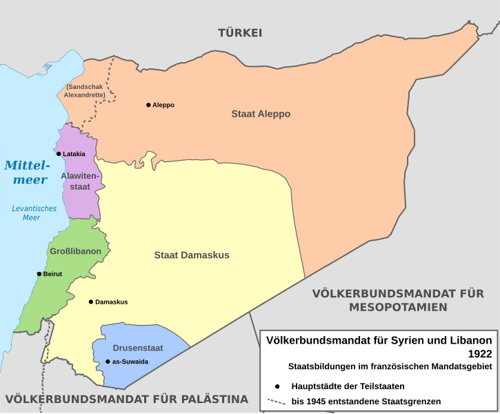
English: Map of French Mandate for Syria and the Lebanon and the states created, 1922, in German. Sources:
Deutsch: Karte des französischen Völkerbundmandats für Syrien und Libanon und der darin geschaffenen Staaten, 1922, auf Deutsch. Quellen:
|
| Date | |
| Source | Own work based on: Syria, administrative divisions - de - colored.svg |
| Author | Don-kun, TUBS, NordNordWest |
| Other versions |
[]
|
| SVG development |


Licensing[edit]
I, the copyright holder of this work, hereby publish it under the following licenses:

|
Permission is granted to copy, distribute and/or modify this document under the terms of the GNU Free Documentation License, Version 1.2 or any later version published by the Free Software Foundation; with no Invariant Sections, no Front-Cover Texts, and no Back-Cover Texts. A copy of the license is included in the section entitled GNU Free Documentation License. |
This file is licensed under the Creative Commons Attribution-Share Alike 3.0 Unported license.
- You are free:
- to share – to copy, distribute and transmit the work
- to remix – to adapt the work
- Under the following conditions:
- attribution – You must give appropriate credit, provide a link to the license, and indicate if changes were made. You may do so in any reasonable manner, but not in any way that suggests the licensor endorses you or your use.
- share alike – If you remix, transform, or build upon the material, you must distribute your contributions under the same or compatible license as the original.
You may select the license of your choice.
File history
Click on a date/time to view the file as it appeared at that time.
| Date/Time | Thumbnail | Dimensions | User | Comment | |
|---|---|---|---|---|---|
| current | 15:33, 4 February 2013 | | 922 × 762 (268 KB) | Don-kun (talk | contribs) | kor grenze zu Plästina, nach http://en.wikisource.org/wiki/Franco-British_Convention_on_Certain_Points_Connected_with_the_Mandates_for_Syria_and_the_Lebanon,_Palestine_and_Mesopotamia |
| 13:22, 23 January 2013 |  | 922 × 762 (300 KB) | Don-kun (talk | contribs) | vielleicht klappts jetzt | |
| 13:21, 23 January 2013 |  | 922 × 762 (300 KB) | Don-kun (talk | contribs) | ergänzungen und korrekturen | |
| 12:18, 22 January 2013 |  | 922 × 762 (293 KB) | Don-kun (talk | contribs) | new version | |
| 15:11, 21 January 2013 |  | 922 × 762 (342 KB) | Don-kun (talk | contribs) | {{Information |Description ={{en|1=Map of French Mandate for Syria and the Lebanon. (draft)}} {{de|1=Karte des französischen Völkerbundmandats für Syrien und Libanon. (Entwurf)}} |Source ={{own}}, based on [[:File:Syria, administrative di... |
You cannot overwrite this file.
File usage on Commons
The following 9 pages use this file:
- File:French Mandate for Syria and the Lebanon map ar.svg
- File:French Mandate for Syria and the Lebanon map de.svg
- File:French Mandate for Syria and the Lebanon map en.svg
- File:French Mandate for Syria and the Lebanon map es.svg
- File:French Mandate for Syria and the Lebanon map fr.svg
- File:French Mandate for Syria and the Lebanon map he.svg
- File:French Mandate for Syria and the Lebanon map hy.png
- File:French Mandate for Syria and the Lebanon map tr.svg
- Template:Other versions/French Mandate for Syria and the Lebanon
File usage on other wikis
The following other wikis use this file:
- Usage on de.wikipedia.org
- Drusen
- Hatay (Provinz)
- Wikipedia:Hauptseite/Jahrestage/November
- Geschichte Syriens
- Wikipedia:Hauptseite/Jahrestage/November/22
- Sandschak Alexandrette
- Konferenz von Sanremo
- Republik Hatay
- Völkerbundmandat für Syrien und Libanon
- Osmanisches Reich
- Alawiten
- Drusenstaat
- Alawitenstaat
- Großlibanon
- Staat Damaskus
- Staat Aleppo
- Wikipedia:Kartenwerkstatt/Archiv/2013-02
- Wikipedia:Café/Archiv 2016 Q4
- Wikipedia:Hauptseite/Archiv/29. Juni 2019
- Wikipedia:Hauptseite/Archiv/22. November 2023
- Libanesisch-syrische Beziehungen