File:Frankfurt Am Main-Stadtbefestigung-Projektion Gegenwart.jpg
Jump to navigation
Jump to search
Size of this preview: 677 × 600 pixels. Other resolutions: 271 × 240 pixels | 542 × 480 pixels | 867 × 768 pixels | 1,156 × 1,024 pixels | 1,975 × 1,750 pixels.
Original file (1,975 × 1,750 pixels, file size: 1.12 MB, MIME type: image/jpeg)
Captions
Captions
Add a one-line explanation of what this file represents
Summary[edit]
| Description |
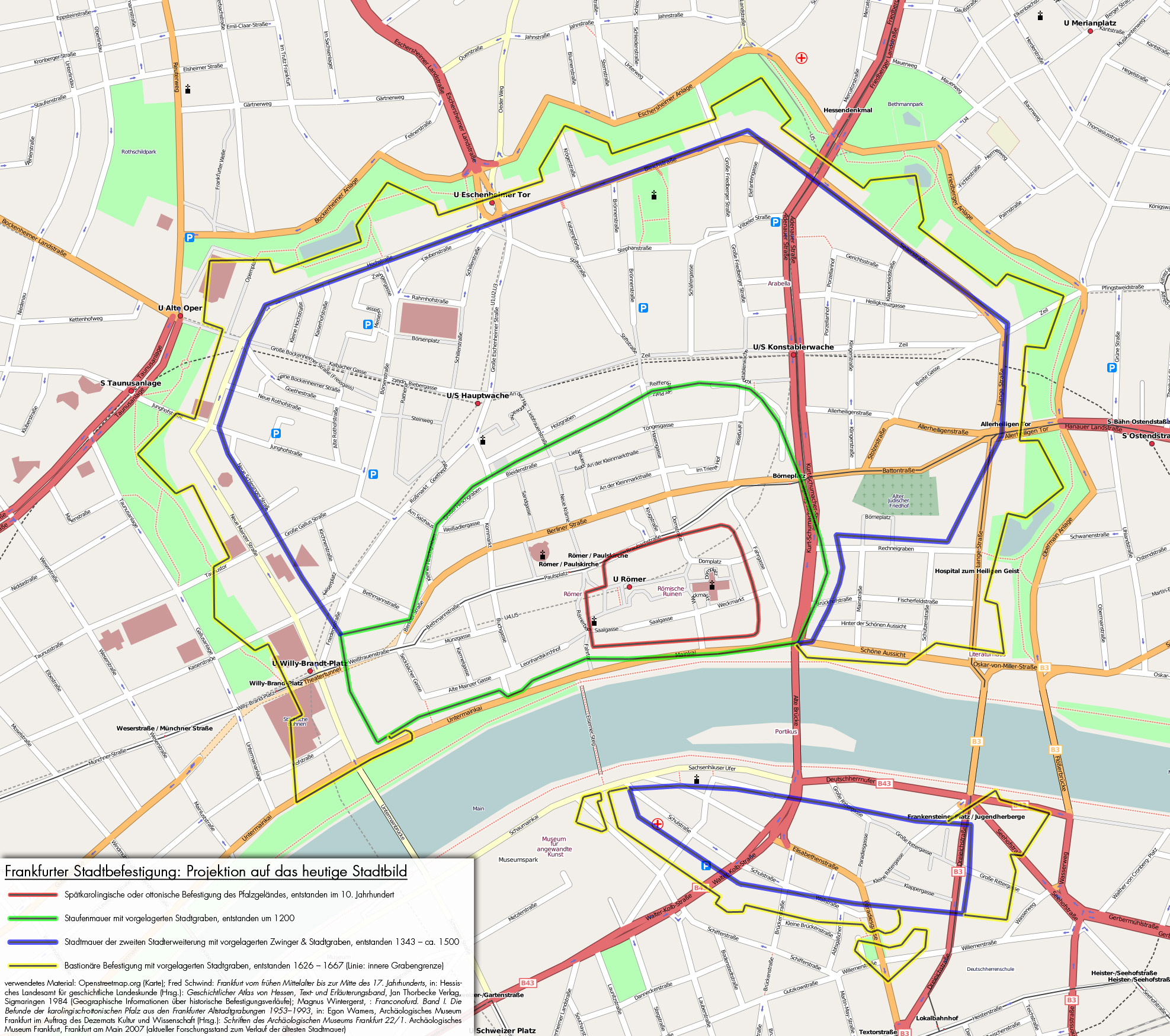
English: Frankfurt on the Main: Projection of the former fortification onto today's cityscape
Deutsch: Frankfurt am Main: Projektion der ehemaligen Stadtbefestigungen auf das heutige Stadtbild |
||
| Date | |||
| Source |
English: Openstreetmap.org (map); Fred Schwind: Frankfurt vom frühen Mittelalter bis zur Mitte des 17. Jahrhunderts, in: Hessisches Landesamt für geschichtliche Landeskunde (Hrsg.): Geschichtlicher Atlas von Hessen, Text- und Erläuterungsband. Jan Thorbecke Verlag, Sigmaringen 1984 (geographical informations on the historical fortifications); Magnus Wintergerst, : Franconofurd. Band I. Die Befunde der karolingisch-ottonischen Pfalz aus den Frankfurter Altstadtgrabungen 1953–1993, in: Egon Wamers, Archäologisches Museum Frankfurt im Auftrag des Dezernats Kultur und Wissenschaft (Hrsg.): Schriften des Archäologischen Museums Frankfurt 22/1. Archäologisches Museum Frankfurt, Frankfurt am Main 2007 (current state of research on the oldest city walls)
Deutsch: Openstreetmap.org (Karte); Fred Schwind: Frankfurt vom frühen Mittelalter bis zur Mitte des 17. Jahrhunderts, in: Hessisches Landesamt für geschichtliche Landeskunde (Hrsg.): Geschichtlicher Atlas von Hessen, Text- und Erläuterungsband. Jan Thorbecke Verlag, Sigmaringen 1984 (Geographische Informationen über historische Befestigungsverläufe); Magnus Wintergerst, : Franconofurd. Band I. Die Befunde der karolingisch-ottonischen Pfalz aus den Frankfurter Altstadtgrabungen 1953–1993, in: Egon Wamers, Archäologisches Museum Frankfurt im Auftrag des Dezernats Kultur und Wissenschaft (Hrsg.): Schriften des Archäologischen Museums Frankfurt 22/1. Archäologisches Museum Frankfurt, Frankfurt am Main 2007 (aktueller Forschungsstand zum Verlauf der ältesten Stadtmauer) |
||
| Creator | |||
| Georeferencing | If inappropriate please set warp_status = skip to hide. | ||
| Other versions |
|


Licensing[edit]
This file is licensed under the Creative Commons Attribution-Share Alike 2.0 Generic license.
- You are free:
- to share – to copy, distribute and transmit the work
- to remix – to adapt the work
- Under the following conditions:
- attribution – You must give appropriate credit, provide a link to the license, and indicate if changes were made. You may do so in any reasonable manner, but not in any way that suggests the licensor endorses you or your use.
- share alike – If you remix, transform, or build upon the material, you must distribute your contributions under the same or compatible license as the original.
File history
Click on a date/time to view the file as it appeared at that time.
| Date/Time | Thumbnail | Dimensions | User | Comment | |
|---|---|---|---|---|---|
| current | 21:35, 29 June 2009 | | 1,975 × 1,750 (1.12 MB) | Mylius (talk | contribs) | Fixed typo and layout of textbox |
| 18:32, 29 June 2009 |  | 1,975 × 1,750 (1.12 MB) | Mylius (talk | contribs) | Adjusted to the current state of research | |
| 23:43, 3 May 2008 |  | 1,975 × 1,750 (987 KB) | Mylius (talk | contribs) | {{Information |Description= |Source= |Date= |Author= |Permission= |other_versions= }} |
You cannot overwrite this file.
File usage on Commons
The following 3 pages use this file:
File usage on other wikis
The following other wikis use this file:
- Usage on de.wikipedia.org
- Benutzer:Karsten11/Liste von Sehenswürdigkeiten in Frankfurt am Main
- Benutzer:Flibbertigibbet
- Benutzer:Magadan/Frankfurt
- Portal:Frankfurt Rhein-Main/Blickfang
- Wallanlagen (Frankfurt am Main)
- Portal Diskussion:Frankfurt Rhein-Main/Blickfang
- Benutzer:Trifi/Portal Frankfurt Rhein-Main
- Portal:Frankfurt Rhein-Main/Test
- Portal:Frankfurt Rhein-Main/Test2
- Frankfurter Stadtbefestigung
- Scharnhäuser
- Fred Schwind
- Benutzer:Baumfreund-FFM/Portal Frankfurt Rhein-Main
- Usage on en.wikipedia.org
- Usage on ja.wikipedia.org
- Usage on sv.wikipedia.org
- Usage on www.wikidata.org
- Usage on zh.wikipedia.org