File:France map Lambert-93 with regions and departments-occupation-eo.svg
Jump to navigation
Jump to search

Size of this PNG preview of this SVG file: 632 × 600 pixels. Other resolutions: 253 × 240 pixels | 506 × 480 pixels | 809 × 768 pixels | 1,079 × 1,024 pixels | 2,158 × 2,048 pixels | 2,000 × 1,898 pixels.
Original file (SVG file, nominally 2,000 × 1,898 pixels, file size: 900 KB)
Captions
Captions
Add a one-line explanation of what this file represents
Summary[edit]
| Description |
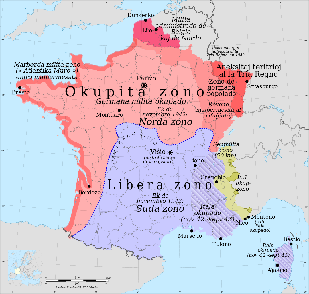
Français : Les zones Francaises occupées pendant la Seconde Guerre Mondiale , Version Espéranto
English: Occupation zones of France during the Second World War, Esperanto version
Esperanto: Okupitaj zonoj de Francio dum la Dua Mondmilito, Esperanta versio |
| Date | |
| Source |
Own work
|
| Author |
Eric Gaba (Sting - fr:Sting) for original blanck map |
| Permission (Reusing this file) |
GFDL / Attribution and Share-Alike required |
| Other versions |
versions[edit]
|


Licensing[edit]
I, the copyright holder of this work, hereby publish it under the following licenses:

|
Permission is granted to copy, distribute and/or modify this document under the terms of the GNU Free Documentation License, Version 1.2 or any later version published by the Free Software Foundation; with no Invariant Sections, no Front-Cover Texts, and no Back-Cover Texts. A copy of the license is included in the section entitled GNU Free Documentation License. |
This file is licensed under the Creative Commons Attribution-Share Alike Attribution-Share Alike 4.0 International, 3.0 Unported, 2.5 Generic, 2.0 Generic and 1.0 Generic license.
- You are free:
- to share – to copy, distribute and transmit the work
- to remix – to adapt the work
- Under the following conditions:
- attribution – You must give appropriate credit, provide a link to the license, and indicate if changes were made. You may do so in any reasonable manner, but not in any way that suggests the licensor endorses you or your use.
- share alike – If you remix, transform, or build upon the material, you must distribute your contributions under the same or compatible license as the original.
You may select the license of your choice.
Licensing[edit]
I, the copyright holder of this work, hereby publish it under the following licenses:
|
|
Permission is granted to copy, distribute and/or modify this document under the terms of the GNU Free Documentation License, Version 1.2 or any later version published by the Free Software Foundation; with no Invariant Sections, no Front-Cover Texts, and no Back-Cover Texts. A copy of the license is included in the section entitled GNU Free Documentation License. |
This file is licensed under the Creative Commons Attribution 3.0 Unported license.
- You are free:
- to share – to copy, distribute and transmit the work
- to remix – to adapt the work
- Under the following conditions:
- attribution – You must give appropriate credit, provide a link to the license, and indicate if changes were made. You may do so in any reasonable manner, but not in any way that suggests the licensor endorses you or your use.
You may select the license of your choice.
File history
Click on a date/time to view the file as it appeared at that time.
| Date/Time | Thumbnail | Dimensions | User | Comment | |
|---|---|---|---|---|---|
| current | 10:27, 1 December 2010 | | 2,000 × 1,898 (900 KB) | ArnoLagrange (talk | contribs) | {{Information |Description={{fr|Les zones Francaises occupées pendant la Seconde Guerre Mondiale , Version Espéranto}} {{en|Occupation zones of France during the Second World War, Esperanto version}} {{eo|Okupitaj zonoj de Francio dum la Dua Mondmilito, |
You cannot overwrite this file.
File usage on Commons
The following 14 pages use this file:
- User:Blahma/Esperanto en Vikimedia Komunejo
- File:France map Lambert-93 topographic-demarcation line.svg
- File:France map Lambert-93 with regions and departments-occupation-be.svg
- File:France map Lambert-93 with regions and departments-occupation-de.svg
- File:France map Lambert-93 with regions and departments-occupation-el.svg
- File:France map Lambert-93 with regions and departments-occupation-eo.svg
- File:France map Lambert-93 with regions and departments-occupation-fr.svg
- File:France map Lambert-93 with regions and departments-occupation-it.svg
- File:France map Lambert-93 with regions and departments-occupation-pt.svg
- File:France map Lambert-93 with regions and departments-occupation-ru.svg
- File:France map Lambert-93 with regions and departments-occupation.svg
- File:France map Lambert 93 with regions-hu.svg
- File:Issy-L'Évêque - carte zone occupée.png
- Template:France map Lambert-93 with regions and departments-occupation
File usage on other wikis
The following other wikis use this file:
- Usage on eo.wikipedia.org
- Usage on io.wikipedia.org