File:France 1800.png
Jump to navigation
Jump to search

Size of this preview: 599 × 599 pixels. Other resolutions: 240 × 240 pixels | 480 × 480 pixels | 768 × 768 pixels | 1,023 × 1,024 pixels | 1,795 × 1,796 pixels.
Original file (1,795 × 1,796 pixels, file size: 152 KB, MIME type: image/png)
Captions
Captions
Add a one-line explanation of what this file represents
Summary[edit]
| Description |
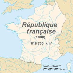
English: Map of France in 1800
Français : Carte de la première république française en 1800 |
| Date | |
| Source | Euratlas - Carte historique de l'Europe en l'an 1800 |
| Author | European citizen |
| Permission (Reusing this file) |
domaine public |
Licensing[edit]
| I, the copyright holder of this work, release this work into the public domain. This applies worldwide. In some countries this may not be legally possible; if so: I grant anyone the right to use this work for any purpose, without any conditions, unless such conditions are required by law. |
File history
Click on a date/time to view the file as it appeared at that time.
| Date/Time | Thumbnail | Dimensions | User | Comment | |
|---|---|---|---|---|---|
| current | 23:01, 5 November 2015 | | 1,795 × 1,796 (152 KB) | TKostolany (talk | contribs) | suppression des frontières des autres pays car il en manque beaucoup |
| 20:22, 7 June 2010 |  | 1,795 × 1,796 (195 KB) | Brisavoine (talk | contribs) | Added land area. | |
| 03:10, 4 June 2010 |  | 1,795 × 1,796 (191 KB) | Brisavoine (talk | contribs) | Autre correction de frontière dans le Limbourg hollandais. | |
| 01:48, 4 June 2010 |  | 1,795 × 1,796 (191 KB) | Brisavoine (talk | contribs) | Correction de la carte : Genève et Monaco faisaient partie de la République française en 1800. | |
| 01:15, 4 June 2010 |  | 1,795 × 1,796 (191 KB) | Brisavoine (talk | contribs) | Escaut jusqu'à son embouchure. | |
| 01:11, 4 June 2010 |  | 1,795 × 1,796 (191 KB) | Brisavoine (talk | contribs) | Correction de la carte : la Flandre zélandaise faisait partie de la République française en 1800. | |
| 16:25, 19 June 2008 |  | 1,795 × 1,796 (346 KB) | European citizen (talk | contribs) | {{Information |Description={{en|1=Map of France in 1800}} {{fr|1=Carte de la première république française en 1800}} |Source=travail personnel (own work) |Author=European citizen |Date=19 juin 2008 |Permission=domaine public | |
You cannot overwrite this file.
File usage on Commons
The following 2 pages use this file:
File usage on other wikis
The following other wikis use this file:
- Usage on ar.wikipedia.org
- Usage on ast.wikipedia.org
- Usage on bg.wikipedia.org
- Usage on ca.wikipedia.org
- Usage on de.wikipedia.org
- Usage on en.wikipedia.org
- Usage on es.wikipedia.org
- Usage on et.wikipedia.org
- Usage on eu.wikipedia.org
- Usage on fr.wikipedia.org
- Usage on fr.wikinews.org
- Catégorie:22 septembre 2008
- Catégorie:22 septembre 2009
- Catégorie:22 septembre 2010
- Catégorie:22 septembre 2011
- Catégorie:22 septembre 2012
- Modèle:Éphéméride-22 septembre
- Évènements du 22 septembre 2012
- Catégorie:22 septembre 2013
- Évènements du 22 septembre 2013
- Catégorie:22 septembre 2014
- Évènements du 22 septembre 2014
- Catégorie:22 septembre 2015
- Évènements du 22 septembre 2015
- Catégorie:22 septembre 2016
- Évènements du 22 septembre 2016
- Catégorie:22 septembre 2017
- Évènements du 22 septembre 2017
- Catégorie:22 septembre 2018
- Évènements du 22 septembre 2018
- Catégorie:22 septembre 2019
- Évènements du 22 septembre 2019
- Catégorie:22 septembre 2020
- Évènements du 22 septembre 2020
- Catégorie:22 septembre 2021
View more global usage of this file.