File:Fort Laramie Treaty, 1851. Indian territories, Like A Fishhook Village, Oregon Trail and Santa Fe Trail.png
Jump to navigation
Jump to search

Size of this preview: 534 × 599 pixels. Other resolutions: 214 × 240 pixels | 428 × 480 pixels | 684 × 768 pixels | 1,243 × 1,395 pixels.
Original file (1,243 × 1,395 pixels, file size: 4.3 MB, MIME type: image/png)
Captions
Captions
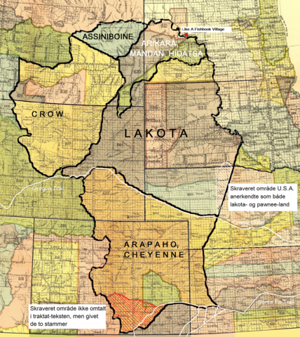
The Fort Laramie Treaty (1851) Indian territories, adapted to text about the treaty.
Summary[edit]
| Description |
Dansk: Fort Laramie traktatens (1851) territorier for lakota-, cheyenne- og arapaho-, crow-, assiniboine- samt mandan-, hidatsa- og arikara-stammen. Endvidere Like A Fishhook Village, Oregon Trail, Santa Fe Trail samt området syd for Arkansas River tildelt cheyennerne- og arapahoerne p.g.a. en misforstået traktattekst (rød skravering). Også området anerkendt som både lakota- og pawnee-land af U.S.A. (hvid skravering).
English: The territories of the Lakota, Cheyenne and Arapaho, Crow, Assiniboine and Mandan, Hidatsa and Arikara tribes. Also Like A Fishhook Village, Oregon Trail and Santa Fe Trail. Further, the south area added to the territory of the Cheyenne and Arapaho due to a misunderstanding of the treaty text (red hatching) – (see ”Historical data and remarks”. U.S Serial Set, Number 4015, 56. Congress, 1. Session. P. 786.) Also the area recognized by the U.S. as territory of both the Lakota and the Pawnee (white hatching) - (See Blaine, Martha Royce: ”Pawnee Passage, 1870-1875.” Norman and London. 1990. P. 212. Also Royce, Charles C.: ”Indian Land Cessions in the United States.” Bureau of American Ethnology. Eighteenth Annual Report. Part 2. Washington, 1899. P. 819.) |
| Date | |
| Source | Royce, Charles C.: Indian Land Cessions in the United States. Bureau of American Ethnology. Eighteenth Annual Report. Part 2. Washington, 1899. GPO |
| Author | Compiled by Charles C, Royce (original maps now adapted to written text) |
Licensing[edit]
| This work is from the Library of Congress. According to the library, there are no known copyright restrictions on the use of this work. |  |

|
This is a file uploaded through the Danish Wikipedia, which has not been reviewed on Commons:
|
File history
Click on a date/time to view the file as it appeared at that time.
| Date/Time | Thumbnail | Dimensions | User | Comment | |
|---|---|---|---|---|---|
| current | 09:02, 9 January 2022 | | 1,243 × 1,395 (4.3 MB) | Indianertosset (talk | contribs) | Uploaded a work by Compiled by Charles C, Royce (original maps now adapted to written text) from Royce, Charles C.: Indian Land Cessions in the United States. Bureau of American Ethnology. Eighteenth Annual Report. Part 2. Washington, 1899. GPO with UploadWizard |
You cannot overwrite this file.
File usage on Commons
There are no pages that use this file.
File usage on other wikis
The following other wikis use this file:
- Usage on da.wikipedia.org
- Usage on it.wikipedia.org
Metadata
Categories:
- Treaty of Fort Laramie (1851)
- Pawnee
- Crow tribe
- Assiniboine
- Mandan
- Hidatsa
- Arikara
- Cheyenne
- Arapaho
- Old maps of Montana
- Maps of North Dakota
- Maps of South Dakota
- Maps of Nebraska
- 1850s maps of Kansas
- Old maps of Colorado
- Maps of Wyoming
- Historic trails
- Santa Fe Trail in Kansas
- Oregon Trail
- Maps of Native American tribal territories
- Danish-language maps