File:Flooding along the Wabash and Ohio Rivers (5694416556).jpg

Original file (720 × 770 pixels, file size: 827 KB, MIME type: image/jpeg)
Captions
Captions
Summary[edit]
.jpg&action=edit§ion=1)
| Description |
English: NASA images acquired May 3, 2011 (top) and acquired April 14, 2010 (bottom)
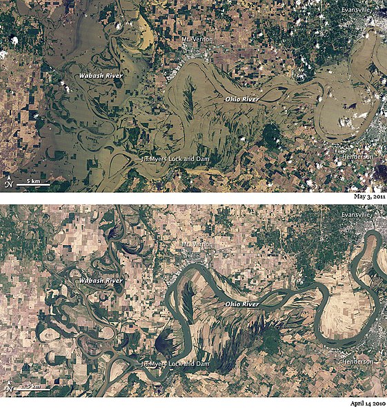
Rivers spilled over their banks at the confluence of the Wabash and Ohio in early May 2011. The flood waters inundated homes, businesses, and agricultural fields. The Thematic Mapper on NASA’s Landsat 5 satellite captured these natural-color images on May 3, 2011 (top), and April 14, 2010 (bottom). Rivers were confined to their banks in April 2010, but the area was awash in muddy water 13 months later. In May 2011, vegetation lining the riverbanks provided ghostly outlines of the normal channels. Communities along the river—Mt. Vernon, Henderson, and Evansville—appear drier than nearby floodplains. By April 30, floods had already blocked many roads, according to the Evansville Courier & Press. Residents had already started moving their belongings to higher ground, if not leaving altogether. On April 30, the Ohio River was forecast to crest on May 2 at the J.T. Myers Lock and Dam at just over 54 feet (16 meters)—the highest flood waters since 1950 in some rural farmlands. The river was predicted to crest on April 30 at 46.4 feet (14.1 meters) in Evansville. According to the Advanced Hydrological Prediction Service (AHPS), the Ohio River rose to 46.78 feet (14.26 meters) at Evansville, and reached 56.94 feet (17.35 meters) at J.T. Myers Lock and Dam on May 5, 2011. The crest at the Lock and Dam was the highest recorded since 1937. Meanwhile, the Wabash River rose to 23.67 feet (7.21 meters) at New Harmony (north of the area shown here)—the highest water level since 1943. Water levels were expected to slowly drop at all three locations, AHPS reported. On May 6, 2011, The Republic reported that flood waters had finally started to recede throughout southern Indiana, and officials had begun to survey damage. No tally of the total cost was yet available. NASA Earth Observatory image created by Jesse Allen and Robert Simmon, using Landsat data provided by the United States Geological Survey. Caption by Michon Scott. Instrument: Landsat 5 - TM To download the full high res files go to: earthobservatory.nasa.gov/NaturalHazards/view.php?id=50470 Credit: NASA Earth Observatory NASA Goddard Space Flight Center enables NASA’s mission through four scientific endeavors: Earth Science, Heliophysics, Solar System Exploration, and Astrophysics. Goddard plays a leading role in NASA’s accomplishments by contributing compelling scientific knowledge to advance the Agency’s mission. Follow us on Twitter Join us on Facebook |
| Date | |
| Source | Flooding along the Wabash and Ohio Rivers |
| Author | NASA Goddard Space Flight Center from Greenbelt, MD, USA |
Licensing[edit]
.jpg&action=edit§ion=2)
- You are free:
- to share – to copy, distribute and transmit the work
- to remix – to adapt the work
- Under the following conditions:
- attribution – You must give appropriate credit, provide a link to the license, and indicate if changes were made. You may do so in any reasonable manner, but not in any way that suggests the licensor endorses you or your use.
| This image was originally posted to Flickr by NASA Goddard Photo and Video at https://flickr.com/photos/24662369@N07/5694416556. It was reviewed on 27 September 2017 by FlickreviewR and was confirmed to be licensed under the terms of the cc-by-2.0. |
File history
Click on a date/time to view the file as it appeared at that time.
| Date/Time | Thumbnail | Dimensions | User | Comment | |
|---|---|---|---|---|---|
| current | 05:44, 27 September 2017 | | 720 × 770 (827 KB) | A1Cafel (talk | contribs) | Transferred from Flickr via Flickr2Commons |
You cannot overwrite this file.
File usage on Commons
The following page uses this file:
.jpg&oldid=798149659)