File:Fingle Bridge - geograph.org.uk - 1243564.jpg
Jump to navigation
Jump to search
No higher resolution available.
Fingle_Bridge_-_geograph.org.uk_-_1243564.jpg (640 × 480 pixels, file size: 120 KB, MIME type: image/jpeg)
Captions
Captions
Add a one-line explanation of what this file represents
Summary[edit]
| Description |
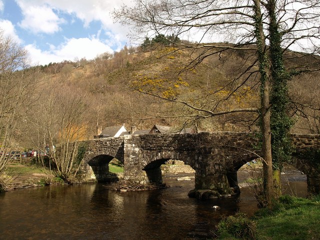
English: Fingle Bridge. Like 438994, a view from upstream on the right bank. The C16 or C17 bridge is described at https://historicengland.org.uk/listing/the-list/list-entry/1146775 . The bridge and its surroundings were the subject of an early GWR jigsaw http://www.theoldtoyshop.com/GWRf.jpg . Behind rises Prestonbury Down, crowned by an Iron Age hill fort. |
| Date | |
| Source | From geograph.org.uk |
| Author | Derek Harper |
| Attribution (required by the license) | Derek Harper / Fingle Bridge / |
| Camera location | | View this and other nearby images on: OpenStreetMap |
|---|
_heading:67.00&language=en)
| Object location | | View this and other nearby images on: OpenStreetMap |
|---|
_heading:67.00&language=en)
Licensing[edit]

|
This image was taken from the Geograph project collection. See this photograph's page on the Geograph website for the photographer's contact details. The copyright on this image is owned by Derek Harper and is licensed for reuse under the Creative Commons Attribution-ShareAlike 2.0 license.
|
This file is licensed under the Creative Commons Attribution-Share Alike 2.0 Generic license.
Attribution: Derek Harper
- You are free:
- to share – to copy, distribute and transmit the work
- to remix – to adapt the work
- Under the following conditions:
- attribution – You must give appropriate credit, provide a link to the license, and indicate if changes were made. You may do so in any reasonable manner, but not in any way that suggests the licensor endorses you or your use.
- share alike – If you remix, transform, or build upon the material, you must distribute your contributions under the same or compatible license as the original.
File history
Click on a date/time to view the file as it appeared at that time.
| Date/Time | Thumbnail | Dimensions | User | Comment | |
|---|---|---|---|---|---|
| current | 16:31, 26 February 2011 | | 640 × 480 (120 KB) | GeographBot (talk | contribs) | == {{int:filedesc}} == {{Information |description={{en|1=Fingle Bridge Like 438994, a view from upstream on the right bank. The C16 or C17 bridge is described at http://www.imagesofengland.org.uk/details/default.aspx?id=85020 . The bridge and its surr |
You cannot overwrite this file.
File usage on Commons
There are no pages that use this file.
File usage on other wikis
The following other wikis use this file:
- Usage on en.wikipedia.org
- Usage on en.wikivoyage.org
- Usage on www.wikidata.org