File:Exemple basique de carte krigée.jpg
Jump to navigation
Jump to search

Size of this preview: 800 × 594 pixels. Other resolutions: 320 × 237 pixels | 640 × 475 pixels | 1,024 × 760 pixels | 1,280 × 950 pixels | 1,830 × 1,358 pixels.
Original file (1,830 × 1,358 pixels, file size: 1.06 MB, MIME type: image/jpeg)
Captions
Captions
Add a one-line explanation of what this file represents
Summary
[edit]
| Description |
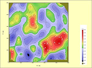
English: Kriging
Français : Exemple de carte obtenue par « krigeage ordinaire ». Les 242 données utilisées sont représentées par de points blancs. La carte estimée est représentée à la fois en palette de couleurs, et en courbes de niveau. |
| Date | |
| Source | Own work |
| Author | Anton Dobrowsky |
L'estimation est réalisée en voisinage glissant (36 points souhaités), et refusée si le voisinage est insuffisamment informé. Le modèle structural est la superposition de deux modèles stationnaires de portées respectives 87 et 175m (isotropes) et d'un faible effet de pépite.
Licensing
[edit]
I, the copyright holder of this work, hereby publish it under the following licenses:

|
Permission is granted to copy, distribute and/or modify this document under the terms of the GNU Free Documentation License, Version 1.2 or any later version published by the Free Software Foundation; with no Invariant Sections, no Front-Cover Texts, and no Back-Cover Texts. A copy of the license is included in the section entitled GNU Free Documentation License. |
This file is licensed under the Creative Commons Attribution-Share Alike 3.0 Unported, 2.5 Generic, 2.0 Generic and 1.0 Generic license.
- You are free:
- to share – to copy, distribute and transmit the work
- to remix – to adapt the work
- Under the following conditions:
- attribution – You must give appropriate credit, provide a link to the license, and indicate if changes were made. You may do so in any reasonable manner, but not in any way that suggests the licensor endorses you or your use.
- share alike – If you remix, transform, or build upon the material, you must distribute your contributions under the same or compatible license as the original.
You may select the license of your choice.
File history
Click on a date/time to view the file as it appeared at that time.
| Date/Time | Thumbnail | Dimensions | User | Comment | |
|---|---|---|---|---|---|
| current | 21:40, 16 February 2011 | | 1,830 × 1,358 (1.06 MB) | Anton Dobrowsky (talk | contribs) | {{Information |Description ={{en|1=Kriging}} {{fr|1=Exemple de carte obtenue par « krigeage ordinaire ». Les 242 données utilisées sont représentées par de points blancs. La carte estimée est représentée à la fois en palette de couleurs, et e |
You cannot overwrite this file.
File usage on Commons
There are no pages that use this file.
File usage on other wikis
The following other wikis use this file:
- Usage on fr.wikipedia.org