File:Europe 1914 Shepherd.jpg
Original file (1,789 × 1,465 pixels, file size: 3.78 MB, MIME type: image/jpeg)
Captions
Captions
Summary[edit]
| Description |
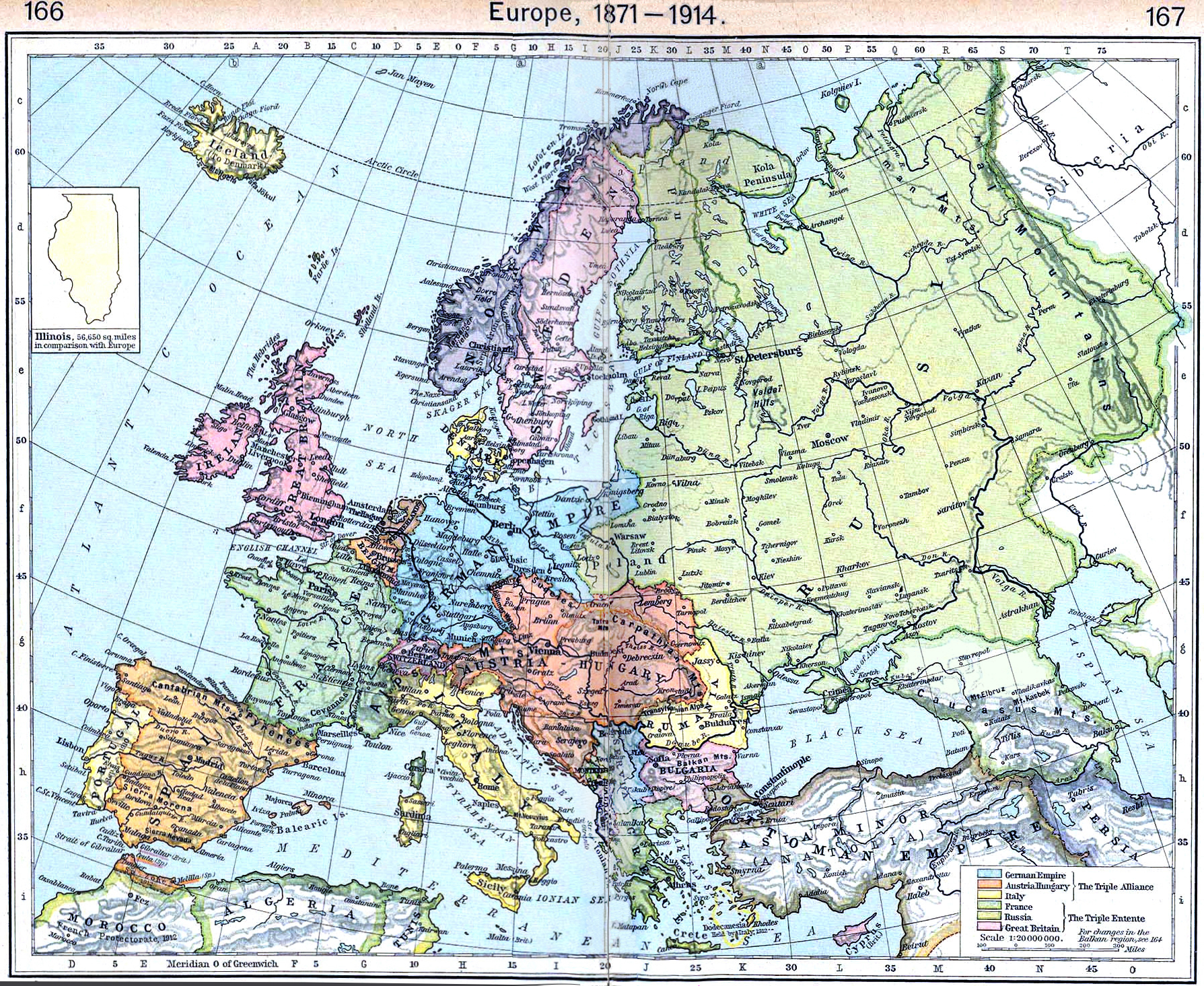
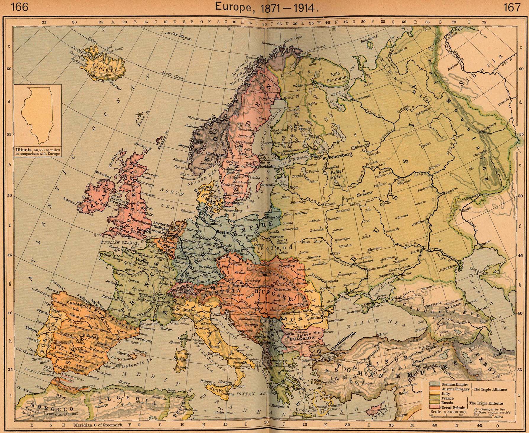
English: Map of Europe in 1914 |
||||||||||||||||||||||
| Date | |||||||||||||||||||||||
| Source | http://www.lib.utexas.edu/maps/historical/shepherd/europe_1871_1914.jpg | ||||||||||||||||||||||
| Author |
|
||||||||||||||||||||||
This is from the 1926 edition of the "Historical Atlas" by William R. Shepherd published by the Henry Holt and Company, New York. It may have been first published earlier in previous editions. The image is from the University of Texas Perry-Castañeda Library Map Collection.
Licensing[edit]
|
This work is in the public domain in its country of origin and other countries and areas where the copyright term is the author's life plus 70 years or fewer.
| |
| This file has been identified as being free of known restrictions under copyright law, including all related and neighboring rights. | |
_en.png)
.png)
.jpg)
File history
Click on a date/time to view the file as it appeared at that time.
| Date/Time | Thumbnail | Dimensions | User | Comment | |
|---|---|---|---|---|---|
| current | 12:15, 20 September 2022 | | 1,789 × 1,465 (3.78 MB) | Рагин1987 (talk | contribs) | Small correction |
| 09:17, 21 March 2012 |  | 1,789 × 1,465 (2.73 MB) | Phoenix7777 (talk | contribs) | Reduced creases | |
| 13:55, 20 March 2012 |  | 1,789 × 1,465 (2.85 MB) | 1Veertje (talk | contribs) | more exposure on the fold | |
| 00:48, 23 February 2011 |  | 1,789 × 1,465 (2.84 MB) | Pearts (talk | contribs) | sides lined up, page bends made a little less visible, vibrance reduced a little | |
| 16:26, 3 October 2010 |  | 1,789 × 1,465 (1.39 MB) | PawełMM (talk | contribs) | flattened & whitened | |
| 14:49, 6 July 2010 |  | 1,789 × 1,465 (623 KB) | Yebellz (talk | contribs) | Whitened Version | |
| 14:41, 6 July 2010 |  | 1,789 × 1,465 (604 KB) | Yebellz (talk | contribs) | {{Information |Description={{en|1=Map of Europe in 1914}} |Source=http://www.lib.utexas.edu/maps/historical/shepherd/europe_1871_1914.jpg |Author=William R. Shepherd |Date=1926 |Permission= |other_versions= }} This is from the 1926 edition of the "Histori |
You cannot overwrite this file.
File usage on Commons
The following 2 pages use this file:
File usage on other wikis
The following other wikis use this file:
- Usage on en.wikipedia.org
- Usage on hu.wikipedia.org
- Usage on hy.wikipedia.org
- Usage on nl.wikipedia.org
- Usage on pl.wikipedia.org
- Usage on pt.wikipedia.org
- Usage on ru.wikipedia.org