File:Europe 180ad roman trade map.png
Jump to navigation
Jump to search

Size of this preview: 800 × 432 pixels. Other resolutions: 320 × 173 pixels | 640 × 345 pixels | 1,024 × 552 pixels | 1,280 × 691 pixels | 2,621 × 1,414 pixels.
Original file (2,621 × 1,414 pixels, file size: 1.24 MB, MIME type: image/png)
Captions
Captions
Add a one-line explanation of what this file represents
Summary[edit]
| Description |
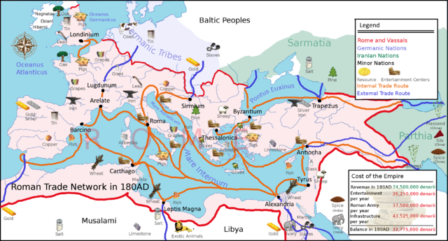
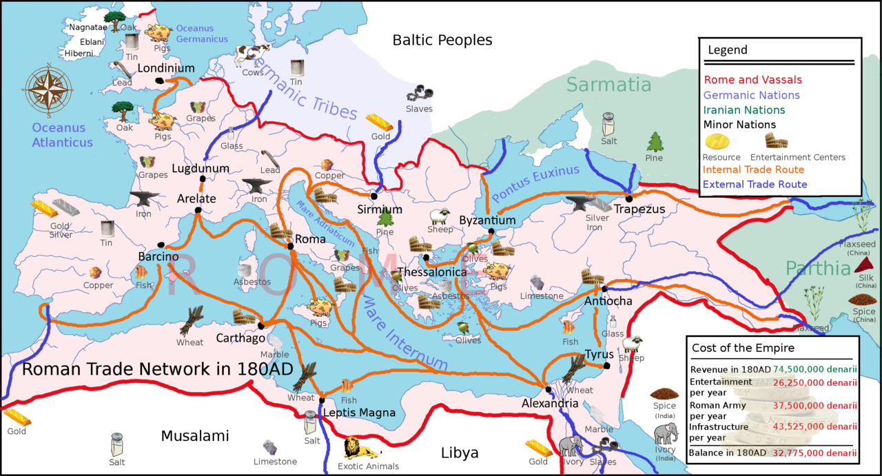
English: A political map of Europe in 180AD showing various Roman trade routes and important trade goods. |
| Date | |
| Source | Own work |
| Author | Adhavoc |
Licensing[edit]
I, the copyright holder of this work, hereby publish it under the following license:
This file is licensed under the Creative Commons Attribution-Share Alike 3.0 Unported license.
- You are free:
- to share – to copy, distribute and transmit the work
- to remix – to adapt the work
- Under the following conditions:
- attribution – You must give appropriate credit, provide a link to the license, and indicate if changes were made. You may do so in any reasonable manner, but not in any way that suggests the licensor endorses you or your use.
- share alike – If you remix, transform, or build upon the material, you must distribute your contributions under the same or compatible license as the original.
File history
Click on a date/time to view the file as it appeared at that time.
| Date/Time | Thumbnail | Dimensions | User | Comment | |
|---|---|---|---|---|---|
| current | 14:23, 29 October 2010 | | 2,621 × 1,414 (1.24 MB) | Adhavoc (talk | contribs) | {{Information |Description={{en|1=A political map of Europe in 180AD showing various Roman trade routes and important trade goods.}} |Source={{own}} |Author=Adhavoc |Date=2010-09-27 |Permission= |other_versions= }} [[Category:Roman Empir |
You cannot overwrite this file.
File usage on Commons
There are no pages that use this file.
File usage on other wikis
The following other wikis use this file:
- Usage on ca.wikipedia.org
- Usage on de.wikipedia.org
- Usage on en.wikipedia.org
- Usage on es.wikipedia.org
- Usage on fa.wikipedia.org
- Usage on fr.wikipedia.org
- Usage on id.wikipedia.org
- Usage on id.wikibooks.org
- Usage on it.wikipedia.org
- Usage on ja.wikipedia.org
- Usage on ko.wikipedia.org
- Usage on ru.wikipedia.org
- Usage on uk.wikipedia.org