File:Empire-byzantin-1450.svg
Jump to navigation
Jump to search

Size of this PNG preview of this SVG file: 800 × 489 pixels. Other resolutions: 320 × 196 pixels | 640 × 391 pixels | 1,024 × 626 pixels | 1,280 × 782 pixels | 2,560 × 1,564 pixels | 1,913 × 1,169 pixels.
Original file (SVG file, nominally 1,913 × 1,169 pixels, file size: 1.51 MB)
Captions
Captions
Add a one-line explanation of what this file represents
Summary[edit]
| Description |
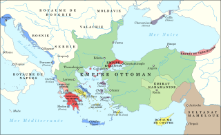
Français : Carte des Balkans et de l'Anatolie en 1450.
Empire byzantin
Despotat d'Epire
Empire de Trébizonde
Empire ottoman
Emirat karamanide
République de Venise
République de Gênes
États latins
Sultanat mamelouk |
| Date | |
| Source |
|
| Author | IvanBondarev |
Licensing[edit]
I, the copyright holder of this work, hereby publish it under the following license:
This file is licensed under the Creative Commons Attribution-Share Alike 4.0 International license.
- You are free:
- to share – to copy, distribute and transmit the work
- to remix – to adapt the work
- Under the following conditions:
- attribution – You must give appropriate credit, provide a link to the license, and indicate if changes were made. You may do so in any reasonable manner, but not in any way that suggests the licensor endorses you or your use.
- share alike – If you remix, transform, or build upon the material, you must distribute your contributions under the same or compatible license as the original.
File history
Click on a date/time to view the file as it appeared at that time.
| Date/Time | Thumbnail | Dimensions | User | Comment | |
|---|---|---|---|---|---|
| current | 14:12, 14 March 2024 | | 1,913 × 1,169 (1.51 MB) | IvanBondarev (talk | contribs) | Couleurs |
| 14:07, 14 March 2024 |  | 1,913 × 1,169 (1.51 MB) | IvanBondarev (talk | contribs) | Corrections | |
| 12:05, 14 March 2024 |  | 1,913 × 1,169 (1.51 MB) | IvanBondarev (talk | contribs) | Uploaded own work with UploadWizard |
You cannot overwrite this file.
File usage on Commons
The following 2 pages use this file:
File usage on other wikis
The following other wikis use this file:
- Usage on fr.wikipedia.org
- Histoire de l'Empire byzantin
- Chute de Constantinople
- Manuel II Paléologue
- Constantin XI Paléologue
- Karamanides
- Guerres turco-byzantines
- Dynastie des Paléologues
- Guerres ottomanes en Europe
- Guerres vénéto-ottomanes
- Guerre vénéto-ottomane (1463-1479)
- Empire byzantin
- Francocratie
- Manuel Chrysaphes
- Histoire des Balkans