File:Ellerker Mill (Demolition) 1913 (archive ref DDEY-1-67) (28583977755).jpg
Ellerker_Mill_(Demolition)_1913_(archive_ref_DDEY-1-67)_(28583977755).jpg (364 × 573 pixels, file size: 127 KB, MIME type: image/jpeg)
Captions
Captions
Summary[edit]
_1913_(archive_ref_DDEY-1-67)_(28583977755).jpg&action=edit§ion=1)
| Description |
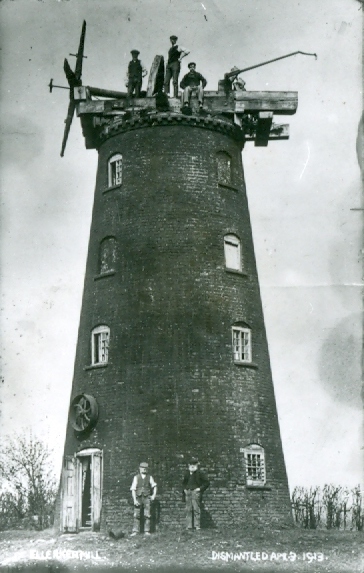
English: The windmill at Ellerker, East Yorkshire, as work began on its demolition on 3rd April 1913.
|
| Date | |
| Source | https://www.flickr.com/photos/erarchives/28583977755/ |
| Author | East Riding Archives |
| Permission (Reusing this file) |
At the time of upload, the image license was automatically confirmed using the Flickr API. For more information see Flickr API detail. |
| Flickr sets |
|
| Flickr pools |
|
| Flickr tags |
|
| Camera location | | View this and other nearby images on: OpenStreetMap |
|---|
_1913_(archive_ref_DDEY-1-67)_(28583977755).jpg¶ms=053.755578_N_-000.599398_E_globe:Earth_type:camera__&language=en)
Licensing[edit]
_1913_(archive_ref_DDEY-1-67)_(28583977755).jpg&action=edit§ion=2)
This image was taken from Flickr's The Commons. The uploading organization may have various reasons for determining that no known copyright restrictions exist, such as:
More information can be found at https://flickr.com/commons/usage/. Please add additional copyright tags to this image if more specific information about copyright status can be determined. See Commons:Licensing for more information. |
| This image was originally posted to Flickr by East Riding Archives at https://flickr.com/photos/138361426@N08/28583977755. It was reviewed on 3 November 2016 by FlickreviewR and was confirmed to be licensed under the terms of the No known copyright restrictions. |
File history
Click on a date/time to view the file as it appeared at that time.
| Date/Time | Thumbnail | Dimensions | User | Comment | |
|---|---|---|---|---|---|
| current | 08:45, 3 November 2016 | | 364 × 573 (127 KB) | Fæ (talk | contribs) | East Riding Archives, Set 72157670549797420, ID 28583977755, Original title Ellerker Mill (Demolition) 1913 (archive ref DDEY-1-67) |
You cannot overwrite this file.
File usage on Commons
There are no pages that use this file.
File usage on other wikis
The following other wikis use this file:
- Usage on en.wikipedia.org
_1913_(archive_ref_DDEY-1-67)_(28583977755).jpg&oldid=861041810)