File:East Loch Tarbert cropped from Admiralty Chart No 2472 Plans on the West Coast of Scotland, Published 1932.jpg
Jump to navigation
Jump to search

Size of this preview: 800 × 507 pixels. Other resolutions: 320 × 203 pixels | 640 × 406 pixels | 1,024 × 649 pixels | 1,280 × 811 pixels | 2,560 × 1,622 pixels | 4,688 × 2,971 pixels.
Original file (4,688 × 2,971 pixels, file size: 7.15 MB, MIME type: image/jpeg)
Captions
Captions
Add a one-line explanation of what this file represents
Summary[edit]
| Warning | The original file is very high-resolution. It might not load properly or could cause your browser to freeze when opened at full size. |
|---|
| Description |
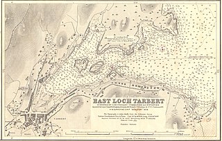
English: Nautical chart of plans on the West Coast of Scotland: Loch Crinan (scale 1:7,500) surveyed by Lieut. Commr. C.W. Sabine 1936 under the direction of Lieut. Commr. W.I. Farquharson; Loch Gilp (scale 1:7,500) officers of H.M.S. Dryad, 1927; Millport (scale 1:10,000) surveyed by Lieut.J.M. Sharpey-Schafer H.M.S. Gulnare, 1940; East Loch Tarbert (scale 1:4,800) surveyed by Lieutenant-Commander A.G.N. Wyatt assisted by Lieut-Commr. R.A. Stephens & Lieuts. K.F. Boxall, C.W. Sabine & J.Y G. Torlesse, H.M. Surveying Ship Beaufort 1928. Not current - not to be used for navigation! |
||||||||||
| Date | |||||||||||
| Source | Scan of original Admiralty Chart | ||||||||||
| Creator |
|
||||||||||
| Geotemporal data | |||||||||||
| Spatial reference system | gnomonic | ||||||||||
| Scale | 1:4,800 | ||||||||||
| Bounding box |
|
||||||||||
| Georeferencing | |||||||||||
| Other versions | |||||||||||

Projection: Gnomonic
Licensing[edit]
This work created by the United Kingdom Government is in the public domain.
This is because it is one of the following:
HMSO has declared that the expiry of Crown Copyrights applies worldwide (ref: HMSO Email Reply)
|
 |
File history
Click on a date/time to view the file as it appeared at that time.
| Date/Time | Thumbnail | Dimensions | User | Comment | |
|---|---|---|---|---|---|
| current | 12:07, 16 February 2023 | | 4,688 × 2,971 (7.15 MB) | Kognos (talk | contribs) | File:Admiralty Chart No 2472 Plans on the West Coast of Scotland, Published 1932.jpg cropped 44 % horizontally, 75 % vertically using CropTool with lossless mode. |
You cannot overwrite this file.
File usage on Commons
The following page uses this file: