File:Earth 720Ma.gif
Jump to navigation
Jump to search

Size of this preview: 800 × 450 pixels. Other resolutions: 320 × 180 pixels | 640 × 360 pixels | 1,024 × 576 pixels | 1,280 × 720 pixels | 1,920 × 1,080 pixels.
Original file (1,920 × 1,080 pixels, file size: 211 KB, MIME type: image/gif, looped, 0.5 s)
Captions
Captions
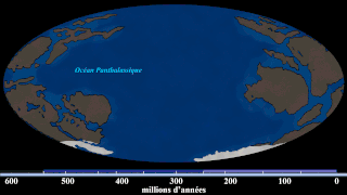
Earth around the end of Tonian and the start of Cryogenian (Tonian-Cryogenian boundary), before the start of Sturtian glaciation.
Summary[edit]
| Description |
English: Hand-drawn images of the Earth around that timeframe. (Based on the first frame of the source GIF, which says this is 740 Ma. But i re-estimate this into around ~720 Ma based on the position of the continents with new Algol's video (at 9:20), which also has new and updated sources) With Algol's video and given that yellow stripe (that estimates the time) doesn't give when it is happening, i gave this illustration with a new estimate. Since this is an estimate, the exact time cannot be measured. Note: this is not a map of Rodinia, this is a map when Rodinia is breaking up at 720 Ma. |
| Date | |
| Source | File:Continental Drift (740 million-to-Today).gif |
| Author | SebM123 |
.gif)
Licensing[edit]
| This file is made available under the Creative Commons CC0 1.0 Universal Public Domain Dedication. | |
| The person who associated a work with this deed has dedicated the work to the public domain by waiving all of their rights to the work worldwide under copyright law, including all related and neighboring rights, to the extent allowed by law. You can copy, modify, distribute and perform the work, even for commercial purposes, all without asking permission.
|
File history
Click on a date/time to view the file as it appeared at that time.
| Date/Time | Thumbnail | Dimensions | User | Comment | |
|---|---|---|---|---|---|
| current | 04:35, 22 May 2020 | | 1,920 × 1,080 (211 KB) | MarioJump83 (talk | contribs) | Uploaded a work by SebM123 from File:Continental Drift (740 million-to-Today).gif with UploadWizard |
You cannot overwrite this file.
File usage on Commons
There are no pages that use this file.
File usage on other wikis
The following other wikis use this file:
- Usage on fi.wikibooks.org
- Usage on pt.wikipedia.org
- Usage on tr.wikipedia.org
- Usage on www.wikidata.org