File:EU27-2008 European Union map.svg
Jump to navigation
Jump to search

Size of this PNG preview of this SVG file: 680 × 520 pixels. Other resolutions: 314 × 240 pixels | 628 × 480 pixels | 1,004 × 768 pixels | 1,280 × 979 pixels | 2,560 × 1,958 pixels.
Original file (SVG file, nominally 680 × 520 pixels, file size: 319 KB)
Captions
Captions
Add a one-line explanation of what this file represents
Summary[edit]
| Description |
Deutsch:
Español:
Français :
Italiano: |
| Date | (UTC) |
| Source | |
| Author |
|
| Other versions |
|


EU-Farbschema / EU color scheme[edit]
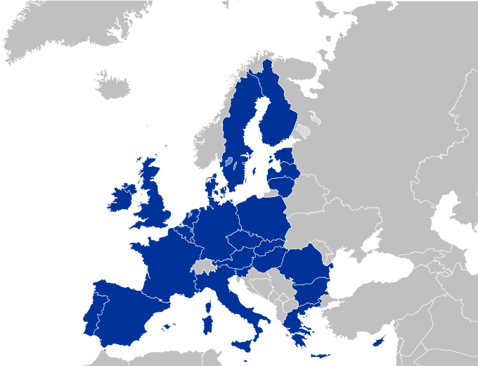
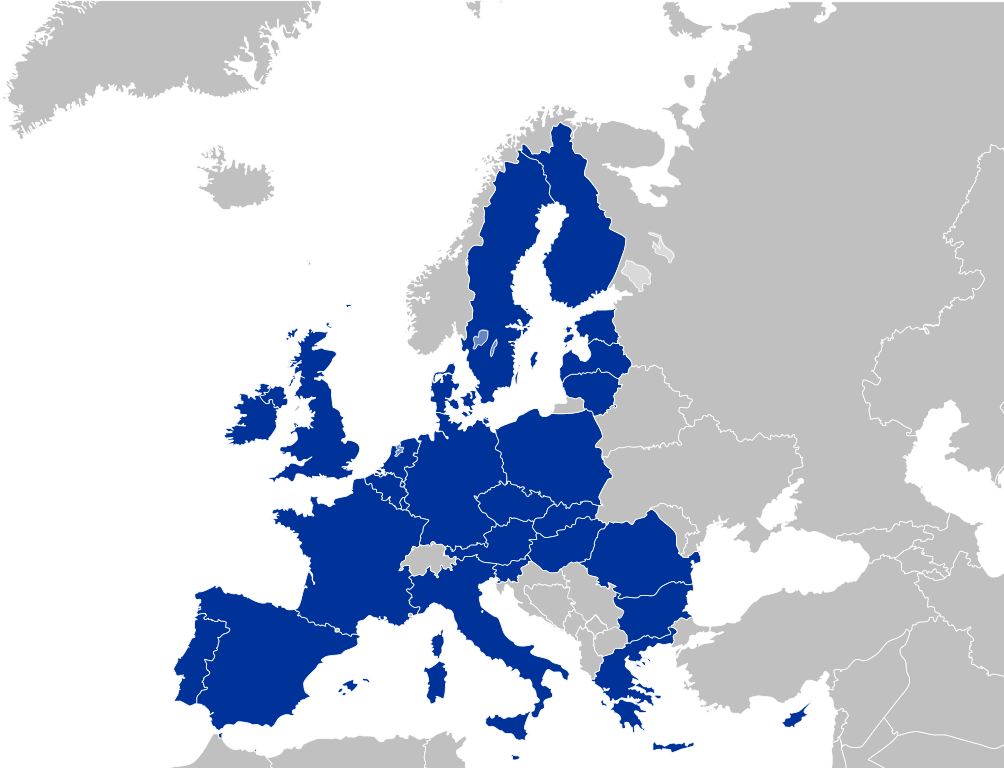
- Europe blue / Europablau / azul europeo / bleu européenne (Pantone; RGB 003399): EU current members
- Regent St Blue (RAL 6034; RGB 9ac0cd): Transition period (see Brexit withdrawal agreement)
- Pantone yellow / Gelb / amarillo / jaune (Pantone; RGB ffcc00): EU new members
- Light blue / Lichtblau / azul claro / bleu clair (RGB 2782bb): EU candidate countries
- Light green / Lichtgrün / verde claro / vert clair (RGB 77bbbc): EU potential candidate countries
- Lawngreen / Grasgrün / verde hierba / vert pré (RGB a0e200): EU membership possible
- Orange / Orange / anaranjado / orange (RGB ff6600): Eastern Partnership
- Emerald green / Smaragdgrün / verde esmeralda / smaragdin (RAL 6001; RGB 276d3a): EFTA member states
- Pastel green / Weißgrün / verde blanquecino / vert blanc (RAL 6019; RGB b3d9b4): EFTA former member states
Licensing[edit]
I, the copyright holder of this work, hereby publish it under the following license:
This file is licensed under the Creative Commons Attribution-Share Alike 2.5 Generic license.
- You are free:
- to share – to copy, distribute and transmit the work
- to remix – to adapt the work
- Under the following conditions:
- attribution – You must give appropriate credit, provide a link to the license, and indicate if changes were made. You may do so in any reasonable manner, but not in any way that suggests the licensor endorses you or your use.
- share alike – If you remix, transform, or build upon the material, you must distribute your contributions under the same or compatible license as the original.
Original upload log[edit]
This image is a derivative work of the following images:
- File:Europe_countries.svg licensed with Cc-by-sa-2.5, Cc-by-sa-2.5/de
- 2009-02-08T23:17:13Z Kolja21 800x520 (564619 Bytes) Rev. Montenegro was deleted
- 2009-02-03T09:39:06Z Koyos 800x520 (548987 Bytes) This map is more accurate, supported by more sources
- 2008-07-24T10:36:24Z Aegean Boy 800x520 (564619 Bytes)
- 2006-05-23T10:51:14Z Tintazul 800x520 (548987 Bytes) {{Tintazul| |Description=Blank map of Europe, showing national borders. SVG format. Includes Kazakhstan. |Date=19 May 2006 }} [[Category:Maps of Europe]]
Uploaded with derivativeFX
File history
Click on a date/time to view the file as it appeared at that time.
| Date/Time | Thumbnail | Dimensions | User | Comment | |
|---|---|---|---|---|---|
| current | 20:36, 26 April 2010 | | 680 × 520 (319 KB) | Quibik (talk | contribs) | Fixed some of the lakes not displaying correctly off-wiki. |
| 23:13, 25 April 2010 |  | 680 × 520 (319 KB) | Quibik (talk | contribs) | another try... | |
| 23:12, 25 April 2010 |  | 680 × 520 (319 KB) | Quibik (talk | contribs) | Trying a RSVG's CSS bug workaround. | |
| 23:09, 25 April 2010 |  | 680 × 520 (318 KB) | Quibik (talk | contribs) | Restored the country id-s that went missing with my edit. Also, RSVG displayed the border thicknesses of EU countries wrongly. | |
| 14:30, 20 April 2010 |  | 680 × 520 (330 KB) | Quibik (talk | contribs) | optimized the source code | |
| 19:39, 10 May 2009 |  | 680 × 520 (519 KB) | Kolja21 (talk | contribs) | Minor edit: Grenzverlauf optimiert | |
| 00:28, 10 May 2009 |  | 680 × 520 (518 KB) | Kolja21 (talk | contribs) | Minor edit: Grenzverlauf optimiert | |
| 17:25, 4 May 2009 |  | 680 × 520 (518 KB) | Kolja21 (talk | contribs) | Isle of Man (IM; till April 2007: GB-IOM) is not part of the EU | |
| 01:10, 4 May 2009 |  | 680 × 520 (518 KB) | Kolja21 (talk | contribs) | Malta | |
| 19:14, 30 April 2009 |  | 680 × 520 (515 KB) | Kolja21 (talk | contribs) | == Summary == {{Information |Description= {{en|1=European Union (EU 27)}} {{legend|#003399|Current members}} {{de|1=Europäische Union (EU 27)}} {{legend|#003399|Mitgliedstaaten}} {{es|1=Unión Europea (UE 27)}} {{legend|#003399|Estados miembros}} |
You cannot overwrite this file.
File usage on Commons
The following 40 pages use this file:
- Enlargement of the European Union
- User:Kolja21
- User:Kolja21/Maps of the European Union
- User:Kolja21/Maps of the European Union enlargement
- File:EC-EU-enlargement animation.gif
- File:EC06-1957-58 EC and USSR map.svg
- File:EC06-1957-58 European Community map.svg
- File:EC09-1973 European Community map.svg
- File:EC09-1973 European Community map enlargement.svg
- File:EC10-1981 European Community map.svg
- File:EC10-1981 European Community map enlargement.svg
- File:EC12-1986 EC and USSR map.svg
- File:EC12-1986 European Community map.svg
- File:EC12-1986 European Community map enlargement.svg
- File:EC12-1990 European Community map.svg
- File:EC12-1990 European Community map enlargement.svg
- File:EU-candidate countries map.svg
- File:EU12-1992-93 European Union map.svg
- File:EU15-1995 European Union map.svg
- File:EU15-1995 European Union map enlargement.svg
- File:EU25-2004 European Union map.svg
- File:EU25-2004 European Union map enlargement.svg
- File:EU27-2007 European Union map.svg
- File:EU27-2007 European Union map enlargement.svg
- File:EU27-2007 as a single entity.svg
- File:EU27-2007 globe.svg
- File:EU27-2008 European Union map-Numbered.svg
- File:EU27-2008 as a single entity in the world.svg
- File:EU27-2012-candidate countries map.svg
- File:EU27-2012-candidate countries only map.svg
- File:EU27-2012-further enlargement map.svg
- File:EU28-2013 European Union map.svg
- File:EU28-2013 European Union map enlargement.svg
- File:EU28-candidate countries only map.svg
- File:EU membership possible map.svg
- File:Eu - members, candidates, association.svg
- File:Euro Plus Pact map.svg
- File:European Union main map.svg
- File:European Union map with arabic names.svg
- File:Map Europe railway platform height.svg
File usage on other wikis
The following other wikis use this file:
- Usage on de.wikipedia.org
- Usage on fr.wikinews.org
- Usage on hu.wikipedia.org
- Usage on mk.wikipedia.org
- Usage on pl.wiktionary.org
- Usage on pt.wikipedia.org