File:Drogheda - St. Laurence's Gate Area (5638235147).jpg

Original file (4,592 × 3,056 pixels, file size: 9.01 MB, MIME type: image/jpeg)
Captions
Captions
Summary[edit]
.jpg&action=edit§ion=1)
| Description |
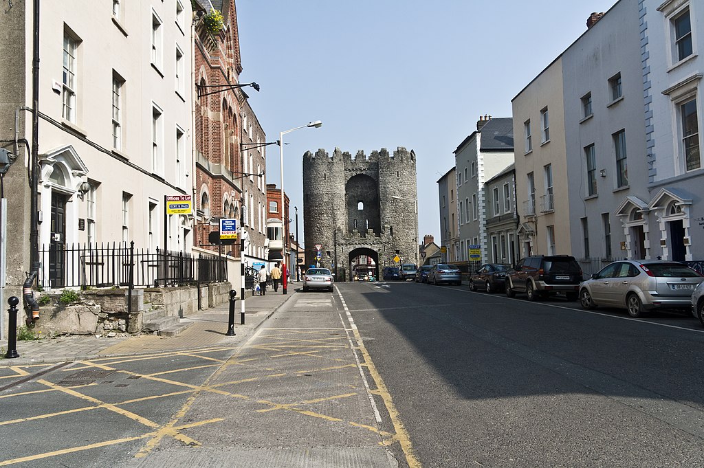
Visitors can appreciate the spectacular dimensions of the mediaeval walls south of the gate at Featherbed Lane. Drogheda's name derives from the Irish ' Droichead Átha ', meaning ' bridge of the ford ' which refers to the River Boyne on which it stands. Drogheda was granted its charter in 1194 by Hugh de Lacy ( after whom the de Lacy bridge in Drogheda is named ) The Anglo Normans made Drogheda one of their primary strongholds, completing the town walls in 1334. The walled area of the Mediaeval Drogheda enclosed one hundred and thirteen acres, making it one of the largest walled towns of the time.St. Laurence's Gate, which led to the Friary of St Laurence, is widely regarded as one of the finest of its kind in Europe. It consists of two lofty circular towers, connected together by a wall, in which there is an archway and it is the by-product of Anglo-Norman concepts of defining urban space with stout walls and earthworks pierced at intervals by heavily defended gates. It was originally one of ten gates which gave ingress and egress to the medieval town of Drogheda. The term 'gate' is in this case a misnomer as this structure is in fact a barbican, or defended fore-work which stood directly outside the original gate of which no surface trace survives. Barbicans were generally placed on the outer edge of the fosses which encircled town walls and acted, along with the gate behind it, as an extra line of defence. Both the gate and the barbican would have possessed stout gates with a drawbridge between the two, which could be raised in case of attack. Twice the walls and gates of Drogheda held out against invasion, firstly when Edward Bruce attacked the town in 1317 and again in 1642 when Sir Phelim O'Neill attempted to take Drogheda. In 1649, Cromwell breached the walls and sacked the town, massacring two thousand Royalist sympathisers and deporting captives as slaves to Barbados. |
| Date | |
| Source | Drogheda - St. Laurence's Gate Area |
| Author | William Murphy from Dublin, Ireland |
Licensing[edit]
.jpg&action=edit§ion=2)
- You are free:
- to share – to copy, distribute and transmit the work
- to remix – to adapt the work
- Under the following conditions:
- attribution – You must give appropriate credit, provide a link to the license, and indicate if changes were made. You may do so in any reasonable manner, but not in any way that suggests the licensor endorses you or your use.
- share alike – If you remix, transform, or build upon the material, you must distribute your contributions under the same or compatible license as the original.
| This image was originally posted to Flickr by infomatique at https://flickr.com/photos/80824546@N00/5638235147. It was reviewed on 20 February 2022 by FlickreviewR 2 and was confirmed to be licensed under the terms of the cc-by-sa-2.0. |
File history
Click on a date/time to view the file as it appeared at that time.
| Date/Time | Thumbnail | Dimensions | User | Comment | |
|---|---|---|---|---|---|
| current | 22:18, 20 February 2022 | | 4,592 × 3,056 (9.01 MB) | SeichanGant (talk | contribs) | Transferred from Flickr via #flickr2commons |
You cannot overwrite this file.
File usage on Commons
There are no pages that use this file.
.jpg&oldid=843866974)