File:Desierto de Lut, Irán, 2016-09-22, DD 44-49 HDR PAN.jpg

Original file (9,175 × 2,105 pixels, file size: 9.35 MB, MIME type: image/jpeg)
Captions
Captions
Summary[edit]
| Description |
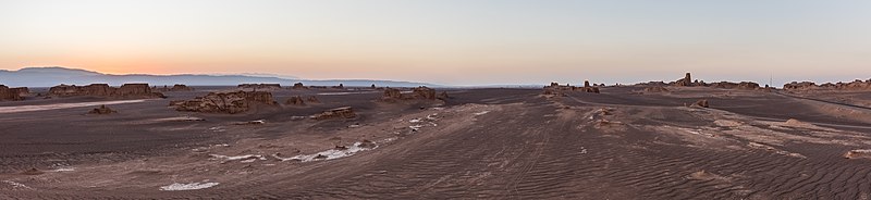
Español: Vista panorámica del desierto de Lut (Dasht-e Loot), que traudcido significa "Desierto del vacío", situados en las provincias de Kermán y Sistán y Baluchistán, Irán. Este parte del mundo tiene particularidad de haber registrado la mayor temperatura medida en la superficie de la tierra (70 °C) y es, desde julio de 2016, patrimonio de la Humanidad según la UNESCO.
English: Panoramic view during sunset of Dasht-e Loot, in English "Emptiness desert", located in the provinces of Kerman and Sistan-Baluchistan, Iran. This place is pretty special for being the spot on the Earth where the highest temperature was ever measured (70 °C or 159 °F) and since July 2016 a UNESCO World Heritage Site.
Polski: Panorama pustyni Lut położonej w ostanach Kerman oraz Sistan i Beludżystan w Iranie. Jest to szczególne miejsce, ponieważ zanotowano tutaj najwyższą temperaturę gruntu na Ziemi, 70,7 °C, a od lipca 2016 pustynia znajduje się na liście światowego dziedzictwa UNESCO.
Čeština: Panoramatický pohled na západ slunce nad solnou pouští Lút v provincii Chorásán na východě Íránu. Na tomto místě byla v červenci roku 2016 naměřena nejvyšší povrchová teplota na Zemi - + 70 °C a oblast je součástí Světového dědictví UNESCO.
Deutsch: Panoramablick während des Sonnenuntergangs in der Dasht-e Lut (persisch دشت لوت, wörtlich „Ebene der Leere“), in den Provinzen Kerman und Sistan-Belutschistan im Iran. An diesem Ort wurde mit 70 °C die höchste jemals auf der Erde gemessene Temperatur dokumentiert und er ist seit Juli 2016 eine Welterbestätte der UNESCO.
Македонски: Залез над пустината Дешт-е Лут во Иран, прогласена за светско наследство на УНЕСКО.
Nederlands: In de Dasht-e Lut in het zuidoosten van Iran zijn bodemtemperaturen van meer dan 70 °C gemeten
Português: Vista panorâmica do deserto de Lut (Dast-e Lut), que traduzido significa "Deserto do vazio", situado nas províncias de Kerman e Sistão-Baluchistão, Irã. |
||||||||||||||||||||
| Date | |||||||||||||||||||||
| Source | Own work | ||||||||||||||||||||
| Author |
|
||||||||||||||||||||

| Camera location | | View this and other nearby images on: OpenStreetMap |
|---|
Assessment[edit]
|
This image was selected as picture of the day on Wikimedia Commons for 27 January 2019. It was captioned as follows: English: Panoramic view during sunset of Dasht-e Lut, in English "Emptiness desert", located in the provinces of Kerman and Sistan-Baluchistan, Iran. This place is pretty special for being the spot on the Earth where the highest temperature ever was measured (70 °C or 159 °F) and since July 2016 a UNESCO World Heritage Site. Other languages:
Čeština: Panoramatický pohled na západ slunce nad solnou pouští Lút v provincii Chorásán na východě Íránu. Na tomto místě byla v červenci roku 2016 naměřena nejvyšší povrchová teplota na Zemi - + 70 °C a oblast je součástí Světového dědictví UNESCO. Deutsch: Panoramablick während des Sonnenuntergangs in der Dasht-e Lut (persisch دشت لوت, wörtlich „Ebene der Leere“), in den Provinzen Kerman und Sistan-Belutschistan im Iran. An diesem Ort wurde mit 70 °C die höchste jemals auf der Erde gemessene Temperatur dokumentiert und er ist seit Juli 2016 eine Welterbestätte der UNESCO. English: Panoramic view during sunset of Dasht-e Lut, in English "Emptiness desert", located in the provinces of Kerman and Sistan-Baluchistan, Iran. This place is pretty special for being the spot on the Earth where the highest temperature ever was measured (70 °C or 159 °F) and since July 2016 a UNESCO World Heritage Site. Español: Vista panorámica del desierto de Lut (Dasht-e Loot), que traudcido significa "Desierto del vacío", situados en las provincias de Kermán y Sistán y Baluchistán, Irán. Este parte del mundo tiene particularidad de haber registrado la mayor temperatura medida en la superficie de la tierra (70 °C) y es, desde julio de 2016, patrimonio de la Humanidad según la UNESCO. Nederlands: In de Dasht-e Lut in het zuidoosten van Iran zijn bodemtemperaturen van meer dan 70 °C gemeten Polski: Panorama pustyni Lut położonej w ostanach Kerman oraz Sistan i Beludżystan w Iranie. Jest to szczególne miejsce, ponieważ zanotowano tutaj najwyższą temperaturę gruntu na Ziemi, 70,7 °C, a od lipca 2016 pustynia znajduje się na liście światowego dziedzictwa UNESCO. Português: Vista panorâmica do deserto de Lut (Dast-e Lut), que traduzido significa "Deserto do vazio", situado nas províncias de Kerman e Sistão-Baluchistão, Irã. Македонски: Залез над пустината Дешт-е Лут во Иран, прогласена за светско наследство на УНЕСКО. |
Licensing[edit]
Another one of my pictures: Want to see more works of mine? click here |
Under this condition:
Please, use this work legally fulfilling the terms of the license! Please, let me know if you use this work outside Wikimedia Commons sending me an email on Furthermore, if you:
please, do not hesitate to contact me. |

|
Please do not overwrite the author's version with a modified image without discussing with the author. The author would like to make corrections only from the uncompressed RAW file. This ensures that changes are preserved and are based on the best possible source to achieve a high quality. If you think that changes are required, please, get in touch with the author. Otherwise, you can upload a new image with a different name without overwriting this one. Use {{Derived from}} or {{Extracted from}} for this purpose. |
- You are free:
- to share – to copy, distribute and transmit the work
- to remix – to adapt the work
- Under the following conditions:
- attribution – You must give appropriate credit, provide a link to the license, and indicate if changes were made. You may do so in any reasonable manner, but not in any way that suggests the licensor endorses you or your use.
- share alike – If you remix, transform, or build upon the material, you must distribute your contributions under the same or compatible license as the original.
File history
Click on a date/time to view the file as it appeared at that time.
| Date/Time | Thumbnail | Dimensions | User | Comment | |
|---|---|---|---|---|---|
| current | 14:22, 25 June 2017 | 9,175 × 2,105 (9.35 MB) | Poco a poco (talk | contribs) | Curves, crop | |
| 17:08, 8 October 2016 | 9,158 × 3,071 (13.56 MB) | Poco a poco (talk | contribs) | User created page with UploadWizard |
You cannot overwrite this file.
File usage on Commons
The following 28 pages use this file:
- User:Poco a poco/Nature
- User:Poco a poco/Panoramas
- User talk:Poco a poco/2017-07
- User talk:Poco a poco/2018-04
- Commons:Featured picture candidates/File:Desierto de Lut, Irán, 2016-09-22, DD 44-49 HDR PAN.jpg
- Commons:Featured picture candidates/Log/July 2017
- Commons:Featured pictures/Places/Natural
- Commons:Featured pictures/chronological/2017-B
- Commons:Picture of the Year/2017/Candidates
- Commons:Picture of the Year/2017/R1/Gallery/2017-B
- Commons:Picture of the Year/2017/R1/Gallery/ALL
- Commons:Picture of the Year/2017/R1/Gallery/M07
- Commons:Picture of the Year/2017/R1/Gallery/Panoramic views
- Commons:Picture of the Year/2017/R1/v/Desierto de Lut, Irán, 2016-09-22, DD 44-49 HDR PAN.jpg
- Commons:Quality images/Subject/Places/Natural structures/Panorama/Archive 2018-2019
- Commons:Quality images candidates/Archives April 07 2018
- Template:Potd/2019-01
- Template:Potd/2019-01-27
- Template:Potd/2019-01-27 (cs)
- Template:Potd/2019-01-27 (de)
- Template:Potd/2019-01-27 (en)
- Template:Potd/2019-01-27 (es)
- Template:Potd/2019-01-27 (hu)
- Template:Potd/2019-01-27 (mk)
- Template:Potd/2019-01-27 (nl)
- Template:Potd/2019-01-27 (pl)
- Template:Potd/2019-01-27 (pt)
- Template:Potd/2019-01-27 (pt-br)
File usage on other wikis
The following other wikis use this file:
- Usage on be-tarask.wikipedia.org
- Usage on crh.wikipedia.org
- Usage on cv.wikipedia.org
- Usage on fa.wikipedia.org
- Usage on fr.wikipedia.org
- Usage on hu.wikipedia.org
- Usage on hy.wikipedia.org
- Usage on it.wikipedia.org
- Usage on ka.wikipedia.org
- Usage on ko.wikipedia.org
- Usage on lbe.wikipedia.org
- Usage on lez.wikipedia.org
- Usage on mk.wikipedia.org
- Usage on os.wikipedia.org
- Usage on pt.wikipedia.org
- Usage on ru.wikipedia.org
- Usage on ru.wikinews.org
- Usage on sah.wikipedia.org
- Usage on sq.wikipedia.org
- Usage on tt.wikipedia.org
- Usage on vep.wikipedia.org
- Usage on zh.wikipedia.org