File:Densidad poblacion Israel.png
Jump to navigation
Jump to search

Size of this preview: 263 × 599 pixels. Other resolutions: 105 × 240 pixels | 211 × 480 pixels | 692 × 1,575 pixels.
Original file (692 × 1,575 pixels, file size: 182 KB, MIME type: image/png)
Captions
Captions
Add a one-line explanation of what this file represents
| Description |
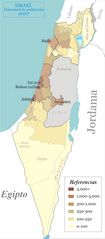
Español: Densidad de población en Israel por región geográfica English: Population density of Israel by geographical region, as defined by the government and CBS |
| Date | (UTC) |
| Source | |
| Author |
|
| Other versions |
|


| This is a retouched picture, which means that it has been digitally altered from its original version. The original can be viewed here: Israel population density.png:
|

|
The copyright holder of this file, Israel Central Bureau of Statistics, allows anyone to use it for any purpose, provided that the copyright holder is properly attributed. Redistribution, derivative work, commercial use, and all other use is permitted. |
Attribution:
The Central Bureau of Statistics (CBS), {{{filename}}}, ({{{access-date}}}), [{{{link}}} available online] copied and distributed as is in accordance with the CBS license.
|

|
According to the CBS license, you may not make the following use of the Information, whether by positive act or by omission:
|
I, the copyright holder of this work, hereby publish it under the following license:

|
Permission is granted to copy, distribute and/or modify this document under the terms of the GNU Free Documentation License, Version 1.2 or any later version published by the Free Software Foundation; with no Invariant Sections, no Front-Cover Texts, and no Back-Cover Texts. A copy of the license is included in the section entitled GNU Free Documentation License. |
| This file is licensed under the Creative Commons Attribution-Share Alike 3.0 Unported license. | ||
| ||
| This licensing tag was added to this file as part of the GFDL licensing update. |
Original upload log[edit]
This image is a derivative work of the following images:
- File:Israel_population_density.png licensed with GFDL
- 2008-04-26T13:48:59Z Ynhockey 692x1575 (227122 Bytes) Eh, what a waste of HD space - made small mistake in last version in 112 sub-district (Beit Shemesh).
- 2008-04-26T13:45:05Z Ynhockey 750x1706 (248272 Bytes) Slightly changed coloring scheme - much more clear now IMO.
- 2007-11-03T22:47:21Z Ynhockey 750x1706 (336937 Bytes) Update for 2007, fixed the Jerusalem sub-district (was incorrect in the first place)
- 2007-07-28T01:36:07Z Ynhockey 750x1706 (337336 Bytes) More pronounced borders on districts, reduced width.
- 2007-07-28T01:29:22Z Ynhockey 822x1575 (326837 Bytes) {{Information |Description=Population density of Israel by geographical region, as defined by the government and CBS. |Source=self-made |Date=July 28, 2007 |Author= [[User:Ynhockey|Ynhockey]] }} {{GFDL-self}}
Uploaded with derivativeFX
File history
Click on a date/time to view the file as it appeared at that time.
| Date/Time | Thumbnail | Dimensions | User | Comment | |
|---|---|---|---|---|---|
| current | 03:48, 11 March 2009 | | 692 × 1,575 (182 KB) | Cansado (talk | contribs) | {{Information |Description=Population density of Israel by geographical region, as defined by the government and CBS. |Source=*File:Israel_population_density.png |Date=2009-03-11 03:47 (UTC) |Author=*File:Israel_population_density.png: [[User: |
You cannot overwrite this file.
File usage on Commons
There are no pages that use this file.
File usage on other wikis
The following other wikis use this file:
- Usage on ast.wikipedia.org
- Usage on es.wikipedia.org
- Usage on gl.wikipedia.org
- Usage on pt.wikipedia.org