File:Deepwater Horizon oil spill NOAA map.jpg
Jump to navigation
Jump to search

Size of this preview: 772 × 599 pixels. Other resolutions: 309 × 240 pixels | 618 × 480 pixels | 962 × 747 pixels.
Original file (962 × 747 pixels, file size: 370 KB, MIME type: image/jpeg)
Captions
Captions
Add a one-line explanation of what this file represents
Summary[edit]
| Description |
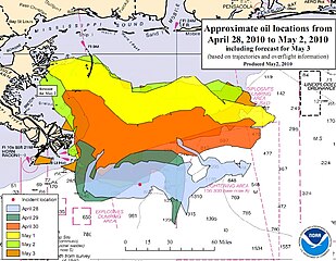
English: Approximate oil locations from April 27, 2010 to May 1, 2010, by NOAA, http://response.restoration.noaa.gov, Public Domain (Government Document) |
| Date | |
| Source | http://response.restoration.noaa.gov/book_shelf/1893_TM-2010-04-30-2145.pdf |
| Author | NOAA |
| Permission (Reusing this file) |
PD-NOAA; PD-USGOV-DOC-NOAA. |
Licensing[edit]
This image is in the public domain because it contains materials that originally came from the U.S. National Oceanic and Atmospheric Administration, taken or made as part of an employee's official duties.
|
File history
Click on a date/time to view the file as it appeared at that time.
| Date/Time | Thumbnail | Dimensions | User | Comment | |
|---|---|---|---|---|---|
| current | 19:57, 17 May 2010 | | 962 × 747 (370 KB) | Ras67 (talk | contribs) | cropped |
| 19:59, 2 May 2010 |  | 966 × 751 (267 KB) | Ewick12 (talk | contribs) | Reverted to version as of 19:58, 2 May 2010 | |
| 19:58, 2 May 2010 |  | 966 × 751 (266 KB) | Ewick12 (talk | contribs) | Reverted to version as of 17:52, 1 May 2010 | |
| 19:58, 2 May 2010 |  | 966 × 751 (267 KB) | Ewick12 (talk | contribs) | Updated locations for 28 April to 2 May with forefast for 3 May. Category:Deepwater Horizon drilling rig explosion | |
| 17:52, 1 May 2010 |  | 966 × 751 (266 KB) | Ewick12 (talk | contribs) | {{Information |Description={{en|1=Approximate oil locations from April 27, 2010 to May 1, 2010, by NOAA, http://response.restoration.noaa.gov, Public Domain (Government Document)}} |Source=http://response.restoration.noaa.gov/book_shelf/1893_TM-2010-04-30 |
You cannot overwrite this file.
File usage on Commons
The following page uses this file:
- File:NOAA map.jpg (file redirect)
File usage on other wikis
The following other wikis use this file:
- Usage on ca.wikipedia.org
- Usage on de.wikipedia.org
- Usage on en.wikinews.org
- Usage on no.wikipedia.org
- Usage on ta.wikinews.org
- Usage on uk.wikipedia.org
- Usage on zh.wikipedia.org