File:DW 629 nowy przebieg.png
Jump to navigation
Jump to search

Size of this preview: 558 × 599 pixels. Other resolutions: 224 × 240 pixels | 447 × 480 pixels | 898 × 964 pixels.
Original file (898 × 964 pixels, file size: 1,016 KB, MIME type: image/png)
Captions
Captions
Add a one-line explanation of what this file represents
| Description |
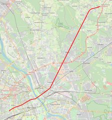
Polski: Mapa przebiegu drogi wojewódzkiej nr 629, woj. mazowieckie, Polska
English: Map of voivodeship road 629, Masovian Voivodeship, Poland |
|||
| Date | ||||
| Source | You may find a page on the OpenStreetMap wiki page for Droga wojewódzka nr 629 | |||
| Creator |
OpenStreetMap contributors (map), Crusier (red overlay) OpenStreetMap contributors |
|||
| Permission (Reusing this file) |
OpenStreetMap data is available under the Open Database License (details). Map tiles are licensed under the Creative Commons Attribution-ShareAlike 2.0 license (CC-BY-SA 2.0).
This file is licensed under the Creative Commons Attribution-Share Alike 2.0 Generic license.
|
|||
| Georeferencing | If inappropriate please set warp_status = skip to hide. |
File history
Click on a date/time to view the file as it appeared at that time.
| Date/Time | Thumbnail | Dimensions | User | Comment | |
|---|---|---|---|---|---|
| current | 20:21, 11 October 2018 | | 898 × 964 (1,016 KB) | Crusier (talk | contribs) | update |
| 14:14, 25 December 2017 |  | 898 × 964 (1,017 KB) | Crusier (talk | contribs) | User created page with UploadWizard |
You cannot overwrite this file.
File usage on Commons
The following 6 pages use this file:
- User:Chumwa/OgreBot/Potential transport maps/2017 December 21-31
- User:Chumwa/OgreBot/Potential transport maps/2018 October 11-20
- User:Chumwa/OgreBot/Transport Maps/2017 December 21-31
- User:Chumwa/OgreBot/Transport Maps/2018 October 11-20
- User:Chumwa/OgreBot/Travel and communication maps/2017 December 21-31
- User:Chumwa/OgreBot/Travel and communication maps/2018 October 11-20
File usage on other wikis
The following other wikis use this file:
- Usage on pl.wikipedia.org