File:DK 1932 Sallingbanen.jpg
Jump to navigation
Jump to search

Size of this preview: 583 × 599 pixels. Other resolutions: 233 × 240 pixels | 467 × 480 pixels | 642 × 660 pixels.
Original file (642 × 660 pixels, file size: 112 KB, MIME type: image/jpeg)
Captions
Captions
Add a one-line explanation of what this file represents
Summary[edit]
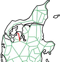
| Description | Map of railways in Northen Jutland in Denmark in 1932 with the now closed state railway from Skive to Glyngøre in red. |
| Date | |
| Source | Own work based on Image:DenmarkStub2.png |
| Author | Leif Jørgensen |
Licensing[edit]

|
Permission is granted to copy, distribute and/or modify this document under the terms of the GNU Free Documentation License, Version 1.2 or any later version published by the Free Software Foundation; with no Invariant Sections, no Front-Cover Texts, and no Back-Cover Texts. A copy of the license is included in the section entitled GNU Free Documentation License. |
| This file is licensed under the Creative Commons Attribution-Share Alike 3.0 Unported license. | ||
| ||
| This licensing tag was added to this file as part of the GFDL licensing update. |
File history
Click on a date/time to view the file as it appeared at that time.
| Date/Time | Thumbnail | Dimensions | User | Comment | |
|---|---|---|---|---|---|
| current | 22:49, 7 February 2013 | | 642 × 660 (112 KB) | Dannebrog Spy (talk | contribs) | {{Information |Description=Map of railways in Northern Jutland in Denmark with the state railway Sallingbanen in red. |Source=Own work based on Image:DenmarkStub2.png |Date=2013-01-25 |Author=Leif Jørgensen |Permission= |ot... |
| 20:39, 7 June 2009 |  | 424 × 439 (34 KB) | Dannebrog Spy (talk | contribs) | {{Information |Description=Map of railways in Northen Jutland in Denmark in 1932 with the now closed state railway from Skive to Glyngøre in red. |Source=Own work based on Image:DenmarkStub2.png |Date=2009-03-06 |Author=[[user:Dannebrog Spy|Leif Jø |
You cannot overwrite this file.
File usage on Commons
The following 2 pages use this file:
File usage on other wikis
The following other wikis use this file:
- Usage on da.wikipedia.org