File:Comptoirsinde.png
Jump to navigation
Jump to search
Size of this preview: 800 × 492 pixels. Other resolutions: 320 × 197 pixels | 640 × 393 pixels | 1,024 × 629 pixels | 1,520 × 934 pixels.
Original file (1,520 × 934 pixels, file size: 568 KB, MIME type: image/png)
Captions
Captions
Add a one-line explanation of what this file represents
Summary[edit]
| Description |
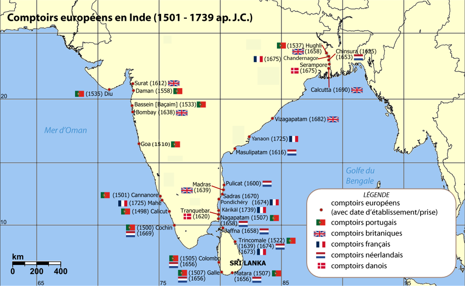
English: Map of India with Sri Lanka, illustrating locations of European settlements in the subcontinent between 1501 and 1739 CE. Français : Carte de l' Inde et du Sri Lanka, illustrant la localisation des colonies et comptoirs européens sur le subcontinent entre 1501 et 1739 |
| Source | Map reference: [1] at w:University of Pennsylvania, with reference varification from: [2] (URL accessed: 23-Mar-2006) |
| Author | User:Miljoshi translated in french by --Kimdime69 00:11, 15 February 2007 (UTC) |
| Other versions | Image:European_settlements_in_India_1501-1739.png |
![[1]](http://www.history.upenn.edu/coursepages/hist086/material/schmidt26a.jpg)

|
This historical map image could be re-created using vector graphics as an SVG file. This has several advantages; see Commons:Media for cleanup for more information. If an SVG form of this image is available, please upload it and afterwards replace this template with
{{vector version available|new image name}}.
It is recommended to name the SVG file “Comptoirsinde.svg”—then the template Vector version available (or Vva) does not need the new image name parameter. |
Licensing[edit]
I, the copyright holder of this work, hereby publish it under the following licenses:

|
Permission is granted to copy, distribute and/or modify this document under the terms of the GNU Free Documentation License, Version 1.2 or any later version published by the Free Software Foundation; with no Invariant Sections, no Front-Cover Texts, and no Back-Cover Texts. A copy of the license is included in the section entitled GNU Free Documentation License. |
| This file is licensed under the Creative Commons Attribution-Share Alike 3.0 Unported license. | ||
| ||
| This licensing tag was added to this file as part of the GFDL licensing update. |
This file is licensed under the Creative Commons Attribution-Share Alike 2.5 Generic, 2.0 Generic and 1.0 Generic license.
- You are free:
- to share – to copy, distribute and transmit the work
- to remix – to adapt the work
- Under the following conditions:
- attribution – You must give appropriate credit, provide a link to the license, and indicate if changes were made. You may do so in any reasonable manner, but not in any way that suggests the licensor endorses you or your use.
- share alike – If you remix, transform, or build upon the material, you must distribute your contributions under the same or compatible license as the original.
You may select the license of your choice.
File history
Click on a date/time to view the file as it appeared at that time.
| Date/Time | Thumbnail | Dimensions | User | Comment | |
|---|---|---|---|---|---|
| current | 11:39, 15 February 2019 | | 1,520 × 934 (568 KB) | Kimdime (talk | contribs) | fixing Goa date 1610>1510 |
| 17:39, 16 November 2006 |  | 1,140 × 700 (196 KB) | Kimdime (talk | contribs) | translation of english speaking map | |
| 17:28, 16 November 2006 |  | 1,140 × 700 (197 KB) | Kimdime (talk | contribs) | translation of European_settlements_in_India_1501-1739.png |
You cannot overwrite this file.
File usage on Commons
The following page uses this file:
File usage on other wikis
The following other wikis use this file:
- Usage on af.wikipedia.org
- Usage on de.wikipedia.org
- Usage on es.wikipedia.org
- Usage on fr.wikipedia.org
- Compagnie britannique des Indes orientales
- Bertrand-François Mahé de La Bourdonnais
- Compagnie française des Indes orientales
- Compagnie des Indes
- Guerre de Sept Ans
- Pondichéry
- Bataille de Négapatam (1746)
- Inde portugaise
- Inde danoise
- Vieilles colonies
- Histoire des bourses de valeurs
- Escadre Suffren dans l'océan Indien
- Discussion utilisateur:NicoScPo/Archives (2009-2014)
- Usage on fr.wikiversity.org
- Usage on it.wikipedia.org
- Usage on www.wikidata.org