File:Columbiarivermap.svg
Jump to navigation
Jump to search

Size of this PNG preview of this SVG file: 600 × 600 pixels. Other resolutions: 240 × 240 pixels | 480 × 480 pixels | 768 × 768 pixels | 1,024 × 1,024 pixels | 2,048 × 2,048 pixels | 612 × 612 pixels.
Original file (SVG file, nominally 612 × 612 pixels, file size: 15.91 MB)
Captions
Captions
Add a one-line explanation of what this file represents
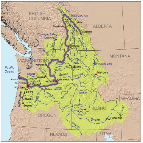
| Description | This is a map of the Columbia River watershed with the Columbia River highlighted. |
| Date | |
| Source | self-made, based on USGS and Digital Chart of the World data. |
| Author | Kmusser |
| SVG development | This oversized W3C-invalid map was created with Adobe Illustrator. |
I, the copyright holder of this work, hereby publish it under the following license:
This file is licensed under the Creative Commons Attribution-Share Alike 3.0 Unported license.
- You are free:
- to share – to copy, distribute and transmit the work
- to remix – to adapt the work
- Under the following conditions:
- attribution – You must give appropriate credit, provide a link to the license, and indicate if changes were made. You may do so in any reasonable manner, but not in any way that suggests the licensor endorses you or your use.
- share alike – If you remix, transform, or build upon the material, you must distribute your contributions under the same or compatible license as the original.
File history
Click on a date/time to view the file as it appeared at that time.
| Date/Time | Thumbnail | Dimensions | User | Comment | |
|---|---|---|---|---|---|
| current | 01:48, 21 September 2008 | | 612 × 612 (15.91 MB) | Kmusser (talk | contribs) | {{Information |Description=This is a map of the Columbia River watershed with the Columbia River highlighted. |Source=self-made, based on USGS and Digital Chart of the World data. |Dat |
You cannot overwrite this file.
File usage on Commons
The following page uses this file: