File:Chick-fil-A locations in USA.svg
Jump to navigation
Jump to search

Size of this PNG preview of this SVG file: 800 × 495 pixels. Other resolutions: 320 × 198 pixels | 640 × 396 pixels | 1,024 × 633 pixels | 1,280 × 791 pixels | 2,560 × 1,583 pixels | 959 × 593 pixels.
Original file (SVG file, nominally 959 × 593 pixels, file size: 97 KB)
Captions
Captions
Add a one-line explanation of what this file represents
| Description |
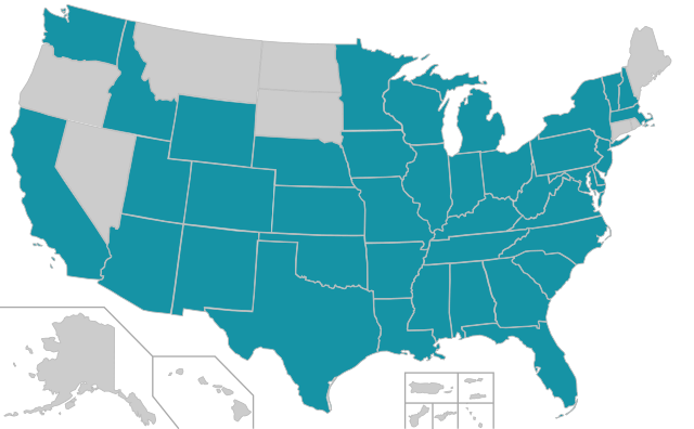
English: A map highlighting locations of the Chick-fil-A locations in the United States. NOTE: This is a text-editable SVG file. Do not use Inkscape or other visual editors to update. |
||||||||
| Date | (UTC) | ||||||||
| Source | |||||||||
| Author | |||||||||
| Permission (Reusing this file) |
I, the copyright holder of this work, hereby publish it under the following licenses:
You may select the license of your choice. |
||||||||
| Other versions |
Derivative works of this file: All the below are of the states (and DC) only.
|
||||||||
| SVG development |
|

Original upload log[edit]
This image is a derivative work of the following images:
- File:Blank_USA,_w_territories.svg licensed with Cc-by-sa-3.0-migrated, GFDL
- 2009-01-30T01:59:59Z Hoshie 959x593 (98189 Bytes) Reverted to version as of 23:58, 14 January 2009 - rv myself; DC can be seen clearly.
- 2009-01-18T23:34:42Z Hoshie 959x593 (102341 Bytes) Put DC in an inset; fixed Tutuila (American Samoa)
- 2009-01-14T23:58:05Z Lokal Profil 959x593 (98189 Bytes) Code cleanup and removed stroke from Guam and American Samoa
- 2009-01-13T05:19:51Z Hoshie 959x593 (101361 Bytes) re did Guam and added American Samoa
- 2007-12-02T16:08:45Z Lokal Profil 959x593 (88960 Bytes) {{Information |Description=A blank map of the United States including Puerto Rico, Guam, the United States Virgin Islands, and the Northern Mariana Islands. |Source=This version was made by [[:User:Lokal_Profil|Lokal_Profil]]
Uploaded with derivativeFX
File history
Click on a date/time to view the file as it appeared at that time.
| Date/Time | Thumbnail | Dimensions | User | Comment | |
|---|---|---|---|---|---|
| current | 02:34, 10 February 2011 | | 959 × 593 (97 KB) | Admrboltz (talk | contribs) | {{Information |Description={{en|A map highlighting locations of the {{w|Chick-fil-A}} locations in the United States. NOTE: This is a text-editable SVG file. Do not use Inkscape or other visual editors to update.}}{{RetouchedPicture|colored in states.|edi |
You cannot overwrite this file.
File usage on Commons
The following page uses this file:
File usage on other wikis
The following other wikis use this file:
- Usage on de.wikipedia.org
- Usage on fa.wikipedia.org