File:Chesapeake and Delaware Canal eastern entrance.jpg
Jump to navigation
Jump to search

Size of this preview: 800 × 527 pixels. Other resolutions: 320 × 211 pixels | 640 × 422 pixels | 1,024 × 674 pixels | 1,500 × 988 pixels.
Original file (1,500 × 988 pixels, file size: 527 KB, MIME type: image/jpeg)
Captions
Captions
Add a one-line explanation of what this file represents
| Description |
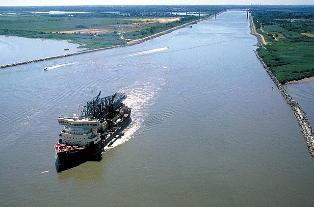
English: The eastern entrance to the Chesapeake & Delaware Canal at Reedy Point, Delaware. Fort Dupont State park is at the right. The Reedy Point Bridge, carrying Delaware State Route 9, is visible in the distance. The U.S. Army Corps of Engineers hopper dredge McFarland is exiting the channel. View is to the east. The channel entrance is located on the Delaware River in New Castle County, Delaware, USA.
|
|||
| Date | not specified or unknown | |||
| Source |
U.S. Army Corps of Engineers Digital Visual Library Image page Image description page Digital Visual Library home page |
|||
| Author | Anthony Bley, U.S. Army Corps of Engineers | |||
| Permission (Reusing this file) |
|
|||
| Location | Delaware River, New Castle County, Delaware, USA |
| Camera location | | View this and other nearby images on: OpenStreetMap |
|---|
File history
Click on a date/time to view the file as it appeared at that time.
| Date/Time | Thumbnail | Dimensions | User | Comment | |
|---|---|---|---|---|---|
| current | 02:46, 8 April 2007 | | 1,500 × 988 (527 KB) | DanMS (talk | contribs) | {{Information | Description = {{en|The eastern entrance to the Chesapeake & Delaware Canal at Reedy Point, Delaware. Fort Dupont State park is at the right. The Reedy Point Bridge, carrying Delaware State Route 9, is visible in the distance. The U. |
You cannot overwrite this file.
File usage on Commons
The following 2 pages use this file:
File usage on other wikis
The following other wikis use this file:
- Usage on de.wikipedia.org
- Usage on en.wikipedia.org
- Usage on es.wikipedia.org
- Usage on fr.wikipedia.org
- Usage on no.wikipedia.org
- Usage on vi.wikipedia.org
- Usage on www.wikidata.org
- Usage on zh.wikipedia.org