File:Chesapeake Bay LOC 2017588252.jpg
Jump to navigation
Jump to search

Size of this preview: 704 × 599 pixels. Other resolutions: 282 × 240 pixels | 564 × 480 pixels | 902 × 768 pixels | 1,203 × 1,024 pixels | 2,405 × 2,048 pixels | 5,656 × 4,816 pixels.
Original file (5,656 × 4,816 pixels, file size: 5.62 MB, MIME type: image/jpeg)
Captions
Captions
Add a one-line explanation of what this file represents
Summary[edit]
| Description |
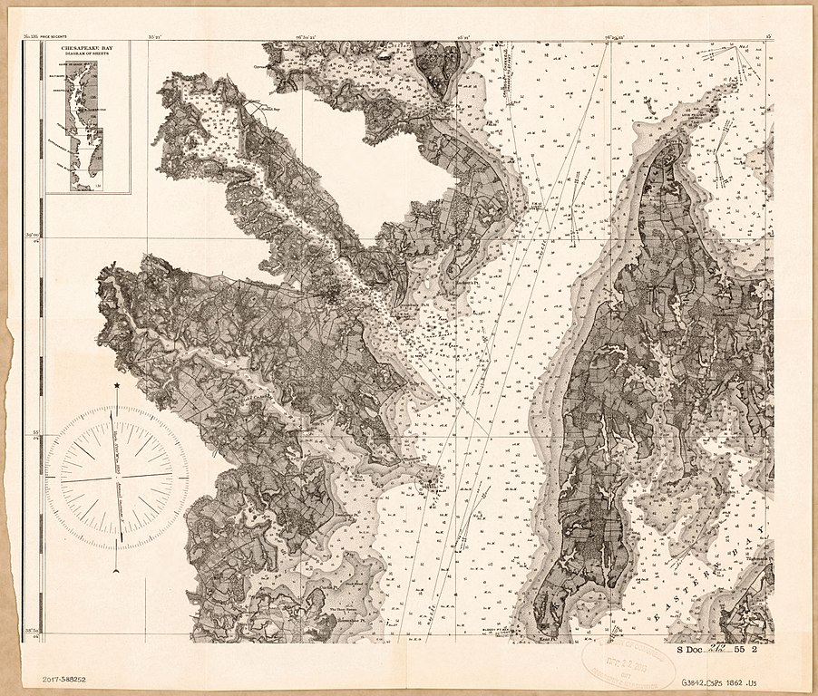
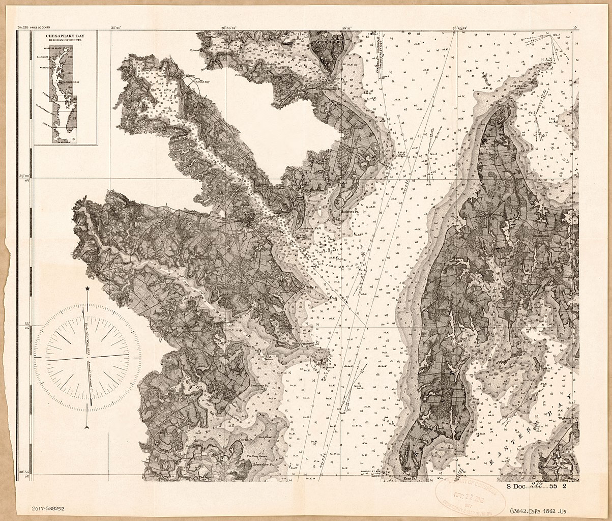
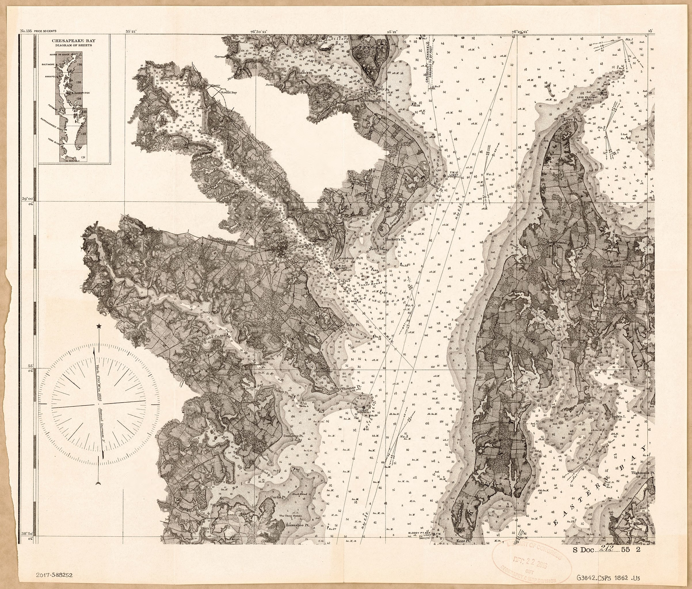
English: Nautical chart of part of the Chesapeake Bay between the Magothy River (at north) and Kent Point (at south) including the Annapolis city region. Relief shown by hachures; depths shown by shading and soundings. Map sheet removed from documentary publication (U.S. Senate document). LC copy imperfect: Part of left-hand margin torn away presumably where the map sheet was attached to the document. Includes inset map of "Chesapeake Bay, diagram of sheets". Available also through the Library of Congress Web site as a raster image. |
||
| Title | Chesapeake Bay | ||
| Shelf ID | G3842.C5P5 1862 .U5 | ||
| Date | |||
| Source | https://www.loc.gov/item/2017588252/ | ||
| Author | United States Coast Survey; United States. Congress. Senate | ||
| Permission (Reusing this file) |
|
||
| Other versions |
|
||
| Location | Annapolis Region · Chesapeake Bay · Chesapeake Bay Watershed · Chesapeake Bay. · Chesapeake Bay Watershed. · Virginia · United States · Maryland | ||
| Part of | American Memory · General Maps · Catalog · Geography And Map Division | ||
| Subject | Chesapeake Bay · Annapolis Region (Md.) · Congress · Senate · Nautical Charts · United States · Maps · Chesapeake Bay Watershed · Information Services · Maryland · Chesapeake Bay (Md. And Va.) |


Licensing[edit]
|
This is a faithful photographic reproduction of a two-dimensional, public domain work of art. The work of art itself is in the public domain for the following reason:
The official position taken by the Wikimedia Foundation is that "faithful reproductions of two-dimensional public domain works of art are public domain".
This photographic reproduction is therefore also considered to be in the public domain in the United States. In other jurisdictions, re-use of this content may be restricted; see Reuse of PD-Art photographs for details. | ||||
File history
Click on a date/time to view the file as it appeared at that time.
| Date/Time | Thumbnail | Dimensions | User | Comment | |
|---|---|---|---|---|---|
| current | 22:06, 10 May 2018 | | 5,656 × 4,816 (5.62 MB) | Fæ (talk | contribs) | LOC Maps https://www.loc.gov/item/2017588252/ #8205 |
You cannot overwrite this file.
File usage on Commons
The following page uses this file: