File:Chemin de fer Franco-Hellenique.png
Jump to navigation
Jump to search

Size of this preview: 524 × 599 pixels. Other resolutions: 210 × 240 pixels | 420 × 480 pixels | 672 × 768 pixels | 895 × 1,024 pixels | 1,791 × 2,048 pixels | 5,027 × 5,748 pixels.
Original file (5,027 × 5,748 pixels, file size: 3.21 MB, MIME type: image/png)
Captions
Captions
Add a one-line explanation of what this file represents
Summary[edit]
| Description |
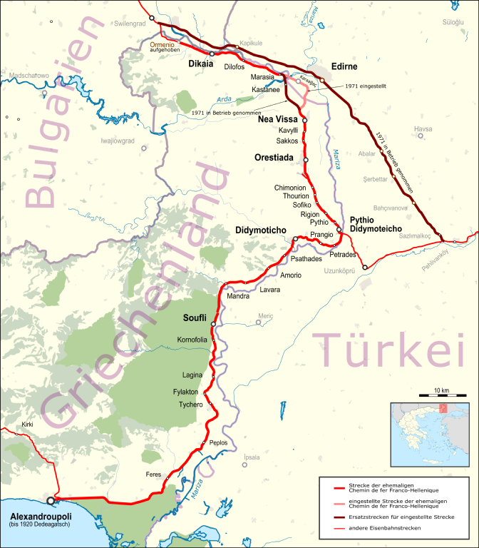
Deutsch: Karte der Chemin_de_fer_Franco-Hellenique im Zustand von 2015 |
| Date | |
| Source |
Map was created by using
|
| Author |
|
| Permission (Reusing this file) |
Map data (c) OpenStreetMap (and) contributors, CC-BY-SA |
Licensing[edit]
This file is licensed under the Creative Commons Attribution-Share Alike 2.0 Generic license.
- You are free:
- to share – to copy, distribute and transmit the work
- to remix – to adapt the work
- Under the following conditions:
- attribution – You must give appropriate credit, provide a link to the license, and indicate if changes were made. You may do so in any reasonable manner, but not in any way that suggests the licensor endorses you or your use.
- share alike – If you remix, transform, or build upon the material, you must distribute your contributions under the same or compatible license as the original.
| This work is licensed under the Open Database License (summary). |
File history
Click on a date/time to view the file as it appeared at that time.
| Date/Time | Thumbnail | Dimensions | User | Comment | |
|---|---|---|---|---|---|
| current | 19:15, 2 February 2016 | | 5,027 × 5,748 (3.21 MB) | Pechristener (talk | contribs) | ...now with correct location map |
| 19:06, 2 February 2016 |  | 5,027 × 5,748 (3.29 MB) | Pechristener (talk | contribs) | improved readability for labels | |
| 18:26, 2 February 2016 |  | 5,027 × 5,748 (3.16 MB) | Pechristener (talk | contribs) | some adjustments: bigger writing, Greece location map | |
| 12:35, 1 February 2016 |  | 5,027 × 5,748 (2.21 MB) | Kopiersperre (talk | contribs) | optipng | |
| 02:02, 31 January 2016 |  | 5,027 × 5,748 (3.15 MB) | Pechristener (talk | contribs) | some disturbing lakes removed in the lower right corner | |
| 01:58, 31 January 2016 |  | 5,027 × 5,748 (3.17 MB) | Pechristener (talk | contribs) | Legende und Location map hinzu | |
| 23:09, 27 January 2016 |  | 5,027 × 5,748 (2.88 MB) | Pechristener (talk | contribs) | Farbschema der Punkte angepasst | |
| 23:03, 27 January 2016 |  | 5,027 × 5,748 (2.88 MB) | Pechristener (talk | contribs) | kontrastreichere Variante ohne Strassen, weitere Korrekturen gemäss Disk in KW | |
| 09:41, 27 January 2016 |  | 5,027 × 5,748 (3.49 MB) | Pechristener (talk | contribs) | {{Information |Description={{de|1=Karte der Chemin_de_fer_Franco-Helleniqu im Zustand von 2015}} |Source = Map was created using [http://www.openstreetmap.org/ Open Street Map] Data |Author = * [[... |
You cannot overwrite this file.
File usage on Commons
The following 9 pages use this file:
- User:Chumwa/OgreBot/Potential transport maps/2016 February 1-9
- User:Chumwa/OgreBot/Potential transport maps/2016 January 21-31
- User:Chumwa/OgreBot/Public transport information/2016 February 1-9
- User:Chumwa/OgreBot/Public transport information/2016 January 21-31
- User:Chumwa/OgreBot/Transport Maps/2016 February 1-9
- User:Chumwa/OgreBot/Transport Maps/2016 January 21-31
- User:Chumwa/OgreBot/Travel and communication maps/2016 February 1-9
- User:Chumwa/OgreBot/Travel and communication maps/2016 January 21-31
- File:Greece–Turkey land border.svg
File usage on other wikis
The following other wikis use this file:
- Usage on de.wikipedia.org