File:Charlton Viaduct - geograph.org.uk - 1528114.jpg
Jump to navigation
Jump to search
No higher resolution available.
Charlton_Viaduct_-_geograph.org.uk_-_1528114.jpg (640 × 385 pixels, file size: 55 KB, MIME type: image/jpeg)
Captions
Captions
Add a one-line explanation of what this file represents
Summary[edit]
| Description |
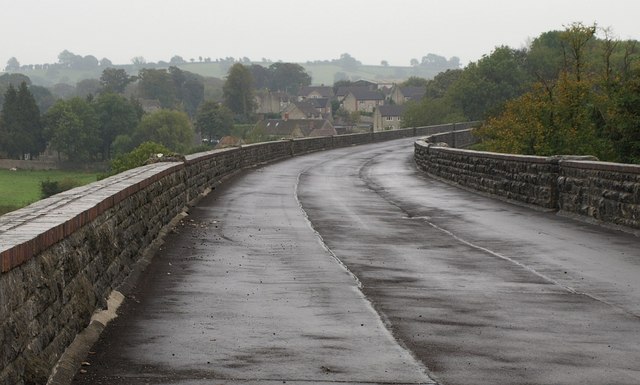
English: Charlton Viaduct. A view of 107181 from its northwestern end, close to the spot where 1528107, looking to the left. The viaduct was "opened 1874 for Somerset and Dorset Joint Railway; Shepton Mallet to Bath extension, doubled in width 1894. Consists of 27 segmental arches carrying elevated trackbed." https://historicengland.org.uk/listing/the-list/list-entry/1058414 . The houses beyond, Woodlands Farm and new housing at Tallowood, are in the village of Charlton. |
| Date | |
| Source | From geograph.org.uk |
| Author | Derek Harper |
| Attribution (required by the license) | Derek Harper / Charlton Viaduct / |
| Camera location | | View this and other nearby images on: OpenStreetMap |
|---|
_heading:157.00&language=en)
| Object location | | View this and other nearby images on: OpenStreetMap |
|---|
_heading:157.00&language=en)
Licensing[edit]

|
This image was taken from the Geograph project collection. See this photograph's page on the Geograph website for the photographer's contact details. The copyright on this image is owned by Derek Harper and is licensed for reuse under the Creative Commons Attribution-ShareAlike 2.0 license.
|
This file is licensed under the Creative Commons Attribution-Share Alike 2.0 Generic license.
Attribution: Derek Harper
- You are free:
- to share – to copy, distribute and transmit the work
- to remix – to adapt the work
- Under the following conditions:
- attribution – You must give appropriate credit, provide a link to the license, and indicate if changes were made. You may do so in any reasonable manner, but not in any way that suggests the licensor endorses you or your use.
- share alike – If you remix, transform, or build upon the material, you must distribute your contributions under the same or compatible license as the original.
File history
Click on a date/time to view the file as it appeared at that time.
| Date/Time | Thumbnail | Dimensions | User | Comment | |
|---|---|---|---|---|---|
| current | 02:52, 3 March 2011 | | 640 × 385 (55 KB) | GeographBot (talk | contribs) | == {{int:filedesc}} == {{Information |description={{en|1=Charlton Viaduct A view of 107181 from its northwestern end, close to the spot where 1528107, looking to the left. The viaduct was "opened 1874 for Somerset and Dorset Joint Railway; Shepton |
You cannot overwrite this file.
File usage on Commons
There are no pages that use this file.