File:Cerro Verde mine Peru.jpg
Cerro_Verde_mine_Peru.jpg (720 × 480 pixels, file size: 355 KB, MIME type: image/jpeg)
Captions
Captions
| Description |
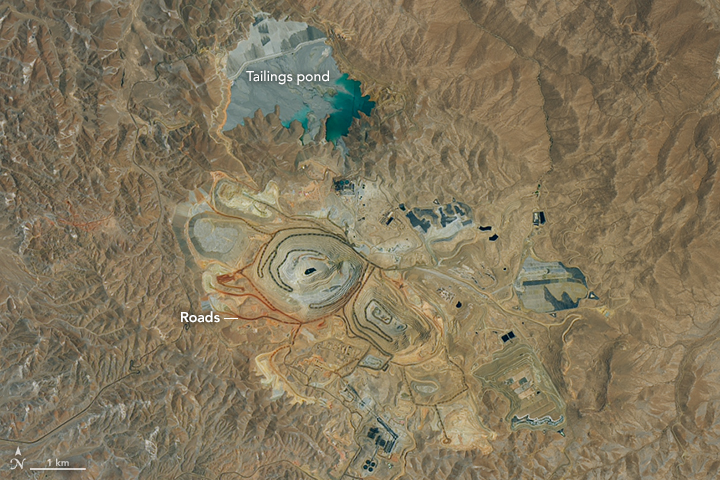
English: Two huge open pits intersected by spirals of roads stand at the center of Cerro Verde, an expansive copper and molybdenum mine in the desert of southwestern Peru. As shown by this satellite image, there is more to the mine than just pits. A complex tangle of supporting facilities, machinery, and other infrastructure surrounds them. Roads, some of them brightly colored, wind throughout the mine complex. Notice how the color of some of the roads changes from red to green as they descend into the mine pits and encounter different types and colors of rock and dust.
Expansive conveyor systems, which look like giant roller coasters, concentrate and crush raw ore. Leaching plants with circular pools sift out more valuable minerals from less desirable waste rock. Wastewater treatment plants and tailing ponds store and process the huge quantities of water required for a mine of this scale. The Operational Land Imager (OLI) on Landsat 8 acquired this image on November 19, 2016. After a major expansion that was completed in 2015, Cerro Verde became one of the top five copper-producing mines in the world. Most of the refined ore eventually makes its way to smelting facilities in Asia, where it is heated and melted down into usable metals and alloys. Copper is ubiquitous in modern society, used in everything from coins to electrical wiring to the hulls of ships. Molybdenum is a metal commonly used in various steel alloys. In the past few decades, the Andes mountain region in South America has emerged as the world’s largest producer of copper. Chile is the top producer of the metal, followed by China. Mines like Cerro Verde have helped push Peru into the upper echelon of production. Between July 2015 and 2016, the nation’s copper production jumped 30 percent, according to statistics from Peru’s Energy and Mines Ministry.
|
|||||
| Date | ||||||
| Source | http://earthobservatory.nasa.gov/IOTD/view.php?id=89410&src=eoa-iotd | |||||
| Author | NASA Operational Land Imager (OLI) on Landsat 8 | |||||
| Permission (Reusing this file) |
|

File history
Click on a date/time to view the file as it appeared at that time.
| Date/Time | Thumbnail | Dimensions | User | Comment | |
|---|---|---|---|---|---|
| current | 16:15, 11 January 2017 | | 720 × 480 (355 KB) | Tillman (talk | contribs) | {{Information |Description ={{en|1=Two huge open pits intersected by spirals of roads stand at the center of Cerro Verde, an expansive copper and molybdenum mine in the desert of southwestern Peru. As shown by this satellite image, there is more to... |
You cannot overwrite this file.
File usage on Commons
The following page uses this file:
File usage on other wikis
The following other wikis use this file:
- Usage on en.wikipedia.org
- Usage on www.wikidata.org