File:CenturyLink Field from the east - from Jose Rizal Bridge in 2014.jpg
Jump to navigation
Jump to search

Size of this preview: 800 × 521 pixels. Other resolutions: 320 × 208 pixels | 640 × 417 pixels | 1,024 × 667 pixels | 1,280 × 833 pixels | 2,560 × 1,667 pixels | 3,775 × 2,458 pixels.
Original file (3,775 × 2,458 pixels, file size: 1.81 MB, MIME type: image/jpeg)
Captions
Captions
Add a one-line explanation of what this file represents
Summary[edit]
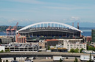
| Description | Seattle's CenturyLink Field viewed from about 2/3-mile (1 km) to the east, from the Jose P. Rizal Bridge, on 12th Avenue South. In the foreground are viaducts/on-ramps connecting westbound Interstate-90 and Dearborn Street with I-5 northbound. The building with the red roof in the intermediate foreground is the former U.S. Immigrant Station and Assay Office, currently used by the INSCAPE art and cultural center. |
| Date | |
| Source | Own work |
| Author | Steve Morgan |
| Permission (Reusing this file) |
See below; user must attribute the photographer on any reuse. |
Licensing[edit]
Steve Morgan, the copyright holder of this work, hereby publishes it under the following licenses:
This file is licensed under the Creative Commons Attribution-Share Alike 4.0 International license.
Attribution: Steve Morgan
- You are free:
- to share – to copy, distribute and transmit the work
- to remix – to adapt the work
- Under the following conditions:
- attribution – You must give appropriate credit, provide a link to the license, and indicate if changes were made. You may do so in any reasonable manner, but not in any way that suggests the licensor endorses you or your use.
- share alike – If you remix, transform, or build upon the material, you must distribute your contributions under the same or compatible license as the original.

|
Permission is granted to copy, distribute and/or modify this document under the terms of the GNU Free Documentation License, Version 1.2 or any later version published by the Free Software Foundation; with no Invariant Sections, no Front-Cover Texts, and no Back-Cover Texts. A copy of the license is included in the section entitled GNU Free Documentation License. |
You may select the license of your choice.
File history
Click on a date/time to view the file as it appeared at that time.
| Date/Time | Thumbnail | Dimensions | User | Comment | |
|---|---|---|---|---|---|
| current | 09:34, 22 April 2019 | | 3,775 × 2,458 (1.81 MB) | Steve Morgan (talk | contribs) | {{Information |Description=Seattle's CenturyLink Field viewed from about 2/3-mile (1 km) to the east, from the Jose P. Rizal Bridge, on 12th Avenue South. In the foreground are viaducts/on-ramps connecting westbound Interstate-90 and Dearborn Street with I-5 northbound. |Source={{own}} |Date=2014-06-06 |Author= Steve Morgan |Permission=See below; user must attribute the photographer on any reuse. |other_versions= }}... |
You cannot overwrite this file.
File usage on Commons
The following page uses this file: