File:Carte géométrique de la Montagne et Combe d’Olle.jpg
Original file (3,333 × 4,566 pixels, file size: 11.6 MB, MIME type: image/jpeg)
Captions
Captions
Summary[edit]
| Description |
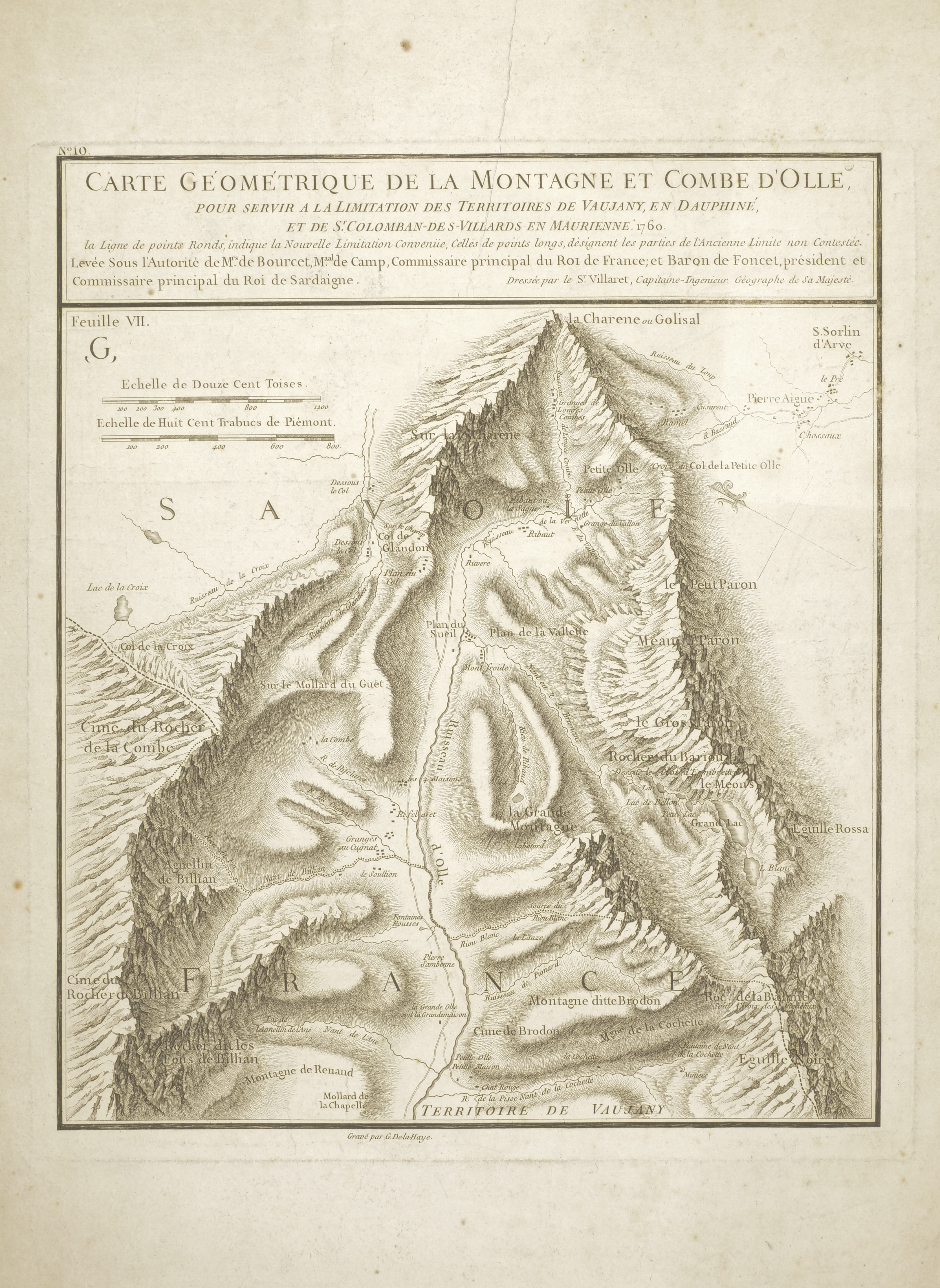
Italiano: Carta geometrica della Montagne e Combe d'Olle, da utilizzare per la limitazione dei territori di Vaujany, nel Delfinato, e di St Colomban - des - Villards nella Maurienne. 1760.
La linea di punti rotondi indica la nuova limitazione concordata, quelli lunghi denotano le parti del vecchio limite indiscusso. Levy Sotto l'autorità dei signor de Bourcet, Maresciallo di Campo, Commissario principale del re di Francia; e il Barone de Foncet, Presidente e Commissario Principale del Re di Sardegna. Redatto da S.r. Villaret, Capitano – Ingegnere Geografico di Sua Maestà. [In centro in basso] Inciso da Guillaume-Nicolas DelahayeEnglish: Geometric map of the Montagne and Combe d'Olle, to be used for the limitation of the territories of Vaujany, in the Dauphiné, and of St Colomban - des - Villards in the Maurienne. 1760.
The line of round dots indicates the new agreed limitation, the long ones denote the parts of the old undisputed limit. Levy Under the authority of Monsieur de Bourcet, Field Marshal, Principal Commissioner of the King of France; and Baron de Foncet, President and Chief Commissioner of the King of Sardinia. Written by S.r. Villaret, Captain - Majesty Geographic Engineer of him. [Bottom center] Engraved by Guillaume-Nicolas DelahayeEspañol: Mapa geométrico de la Montagne y Combe d'Olle, que se utilizará para la limitación de los territorios de Vaujany, en Dauphiné, y de St Colomban - des - Villards en Maurienne. 1760.
La línea de puntos redondos indica la nueva limitación acordada, los largos denotan las partes del antiguo límite indiscutible. Levy Bajo la autoridad de Monsieur de Bourcet, mariscal de campo, comisario principal del rey de Francia; y el Barón de Foncet, Presidente y Comisario Mayor del Rey de Cerdeña. Escrito por Sr. Villaret, Capitán - Ingeniero Geográfico de Su Majestad. [Abajo al centro] Grabado por Guillaume-Nicolas DelahayeFrançais : Carte géométrique de la Montagne et de la Combe d'Olle, à utiliser pour la délimitation des territoires de Vaujany, dans le Dauphiné, et de St Colomban - des - Villards en Maurienne. 1760.
La ligne de points ronds indique la nouvelle limite convenue, les longues indiquent les parties de l'ancienne limite incontestée. Lévy Sous l'autorité de Monsieur de Bourcet, maréchal de campagne, commissaire principal du roi de France ; et le baron de Foncet, président et commissaire en chef du roi de Sardaigne. Écrit par S.r. Villaret, Capitaine - Ingénieur Géographe de Sa Majesté. [En bas au centre] Gravé par Guillaume-Nicolas Delahaye |
| Date | |
| Source | |
| Author | Pierre̠Joseph Bourcet; Jean Villaret; Guillaume-Nicolsa Delahaye |

Licensing[edit]
This image is in the public domain because it is a mere mechanical scan or photocopy of a public domain original, or – from the available evidence – is so similar to such a scan or photocopy that no copyright protection can be expected to arise. The original itself is in the public domain for the following reason:
This tag is designed for use where there may be a need to assert that any enhancements (eg brightness, contrast, colour-matching, sharpening) are in themselves insufficiently creative to generate a new copyright. It can be used where it is unknown whether any enhancements have been made, as well as when the enhancements are clear but insufficient. For known raw unenhanced scans you can use an appropriate {{PD-old}} tag instead. For usage, see Commons:When to use the PD-scan tag.  | ||||
File history
Click on a date/time to view the file as it appeared at that time.
| Date/Time | Thumbnail | Dimensions | User | Comment | |
|---|---|---|---|---|---|
| current | 15:03, 7 October 2022 | | 3,333 × 4,566 (11.6 MB) | Vilma.bono (talk | contribs) | Uploaded a work by Pierre̠Joseph Bourcet; Jean Villaret; Guillaume-Nicolsa Delahaye from {{Institution:Biblioteca di storia e cultura del Piemonte "Giuseppe Grosso"}} with UploadWizard |
You cannot overwrite this file.
File usage on Commons
There are no pages that use this file.