File:Carte générale des environs de la Saline de Chaux.jpg
Original file (3,123 × 2,441 pixels, file size: 3.44 MB, MIME type: image/jpeg)
Captions
Captions
Summary[edit]
| Description |
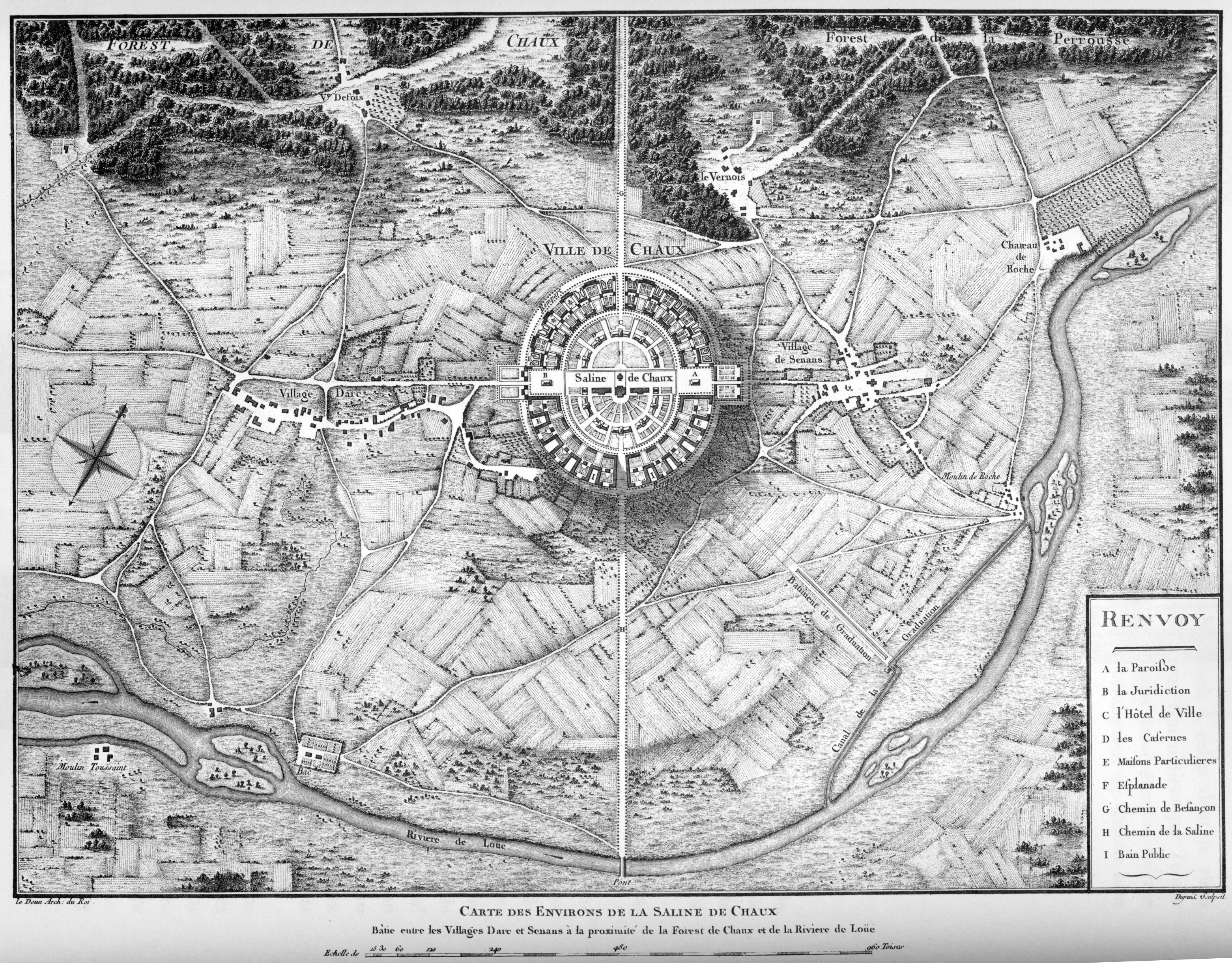
Français : Carte générale des environs de la Saline de Chaux – Plan de la saline. Le bâtiment de graduation et le canal y sont figurés au sud-est de celle-ci. |
| Date | before 1805 |
| Source |
Français : Planche 14 de « L'architecture considérée sous le rapport de l'art, des moeurs et de la législation », Paris, 1804 |
| Author | Unknown author (cf. bottom right corner of the map) |
Licensing[edit]
|
This work is in the public domain in its country of origin and other countries and areas where the copyright term is the author's life plus 70 years or fewer.
| |
| This file has been identified as being free of known restrictions under copyright law, including all related and neighboring rights. | |
| Annotations | This image is annotated: View the annotations at Commons |
File history
Click on a date/time to view the file as it appeared at that time.
| Date/Time | Thumbnail | Dimensions | User | Comment | |
|---|---|---|---|---|---|
| current | 12:50, 18 May 2007 | | 3,123 × 2,441 (3.44 MB) | Jean-Christophe BENOIST (talk | contribs) | == Description == ''Carte générale des environs de la Saline de Chaux'' Planche 14 de « L'architecture considérée sous le rapport de l'art, des moeurs et de la législation », Paris, 1804 Category:Royal Saltworks at Arc-et-Senans == Licensing |
| 21:10, 29 May 2006 |  | 600 × 481 (113 KB) | Cyberugo~commonswiki (talk | contribs) | ''Carte générale des environs de la Saline de Chaux'' Planche 14 de « L'architecture considérée sous le rapport de l'art, des moeurs et de la législation », Paris, 1804 Category:Royal Saltworks at Arc-et-Senans |
You cannot overwrite this file.
File usage on Commons
The following page uses this file:
File usage on other wikis
The following other wikis use this file:
- Usage on es.wikipedia.org
- Usage on fr.wikipedia.org
- Usage on ja.wikipedia.org
- Usage on ru.wikipedia.org