File:Carte du Sahara et du bassin moyen du Niger - dressée par A. Blachère d'après Barth, Duveyrier et les principaux explorateurs - btv1b525049417 (1 of 2).jpg

Original file (10,565 × 9,036 pixels, file size: 10.16 MB, MIME type: image/jpeg)
Captions
Captions
Summary[edit]
| Warning | The original file is very high-resolution. It might not load properly or could cause your browser to freeze when opened at full size. |
|---|
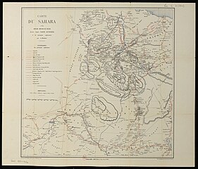
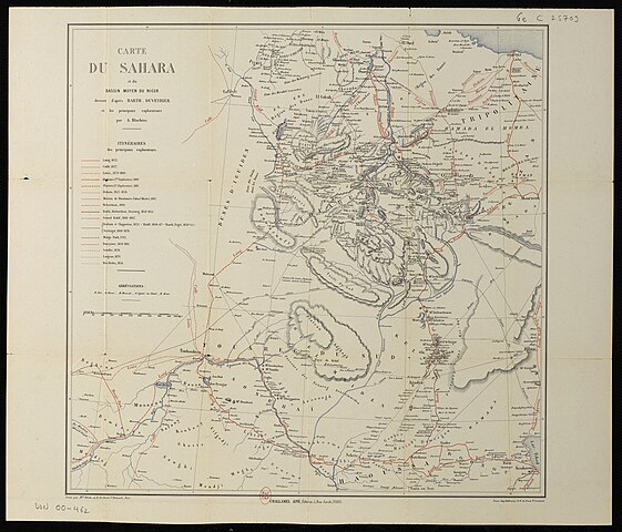
| Carte du Sahara et du bassin moyen du Niger / dressée par A. Blachère d'après Barth, Duveyrier et les principaux explorateurs
( |
|||||||||||||||||||||||||||
|---|---|---|---|---|---|---|---|---|---|---|---|---|---|---|---|---|---|---|---|---|---|---|---|---|---|---|---|
| Author |
Barth, Heinrich (1821-1865). Auteur adapté Duveyrier, Henri (1840-1892). Auteur adapté Blachère, A. (18..-18..?). Cartographe Perrin, Maurice (18..-18..?). Graveur |
||||||||||||||||||||||||||
| Title |
Carte du Sahara et du bassin moyen du Niger / dressée par A. Blachère d'après Barth, Duveyrier et les principaux explorateurs |
||||||||||||||||||||||||||
| Description |
Français : Sujet : Laing, Alexander Gordon (1794-1826) -- Voyages
Caillié, René (1799-1838) -- Voyages Lenz, Oskar (1848-1925) -- Voyages Flatters, Paul (1832-1881) -- Voyages Dickson (18..-18..? ; explorateur) -- Voyages Mircher, Hippolyte (1820-1878) Richardson, James (1806-1851) -- Voyages Rohlfs, Gerhard (1831-1896) -- Voyages Denham, Dixon (1768-1828) -- Voyages Barth, Heinrich (1821-1865) -- Voyages Clapperton, Hugh (1788-1827) -- Voyages Vogel (18..-18..? ; explorateur) -- Voyages Nachtigal, Gustav (1834-1885) -- Voyages Park, Mungo (1771-1805) -- Voyages Soleillet, Paul (1842-1886) -- Voyages Largeau, Victor (1842-1897) -- Voyages Bou Derba, Ismaël (1823-1878) -- Voyages Overweg, Adolf (1822-1852) -- Voyages Découverte et exploration Sahara, Désert du -- Découverte et exploration Niger (cours d'eau) -- Bassin -- Exploration Échelle(s) : 1: Couverture : Afrique (parties) Niger W 15° - E 15° / N 35° - N 10° Langue : français Éditeur : 5, rue Jacob (Paris) Challamel Ainé (Paris) |
||||||||||||||||||||||||||
| Date | 1881 | ||||||||||||||||||||||||||
| Dimensions | height: 66 cm (25.9 in); width: 56 cm (22 in) | ||||||||||||||||||||||||||
| Collection |
|
||||||||||||||||||||||||||
| References |
Français : Notice du catalogue : http://catalogue.bnf.fr/ark:/12148/cb40669267r |
||||||||||||||||||||||||||
| Source/Photographer |
Français : Bibliothèque nationale de France, département Cartes et plans, GE C-25709
Bibliothèque nationale de France (1/2) |
||||||||||||||||||||||||||
| Permission (Reusing this file) |
|
||||||||||||||||||||||||||

.jpg&action=edit§ion=1)
File history
Click on a date/time to view the file as it appeared at that time.
| Date/Time | Thumbnail | Dimensions | User | Comment | |
|---|---|---|---|---|---|
| current | 02:46, 15 August 2022 | | 10,565 × 9,036 (10.16 MB) | Gzen92Bot (talk | contribs) | Gallica btv1b525049417 |
You cannot overwrite this file.
File usage on Commons
The following page uses this file:
.jpg)
.jpg&oldid=875181156)