File:Carte Fortifications Paris et environs 1841.jpg
Jump to navigation
Jump to search

Size of this preview: 800 × 592 pixels. Other resolutions: 320 × 237 pixels | 640 × 474 pixels | 1,024 × 758 pixels | 1,280 × 948 pixels | 2,560 × 1,896 pixels | 10,224 × 7,572 pixels.
Original file (10,224 × 7,572 pixels, file size: 31.83 MB, MIME type: image/jpeg)
Captions
Captions
Add a one-line explanation of what this file represents
Summary[edit]
| Warning | The original file is very high-resolution. It might not load properly or could cause your browser to freeze when opened at full size. |
|---|
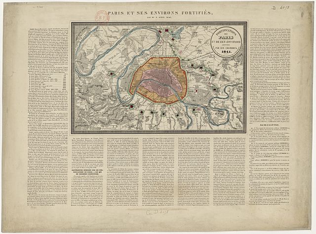
| Fortifications de Paris et de ses environs adoptées par les Chambres
( |
|||||||||||||||||||||||||||
|---|---|---|---|---|---|---|---|---|---|---|---|---|---|---|---|---|---|---|---|---|---|---|---|---|---|---|---|
| Title |
Fortifications de Paris et de ses environs adoptées par les Chambres |
||||||||||||||||||||||||||
| Description |
Français : Carte des fortifications de Paris et environs. English: Map of the fortifications of Paris. |
||||||||||||||||||||||||||
| Date | 1841 | ||||||||||||||||||||||||||
| Dimensions | 54 x 40 cm | ||||||||||||||||||||||||||
| Collection |
|
||||||||||||||||||||||||||
| Source/Photographer |
Bibliothèque nationale de France |
||||||||||||||||||||||||||

Licensing[edit]
| Previous public domain rationale, no longer applicable | ||
|---|---|---|
|
File history
Click on a date/time to view the file as it appeared at that time.
| Date/Time | Thumbnail | Dimensions | User | Comment | |
|---|---|---|---|---|---|
| current | 13:59, 11 March 2012 | | 10,224 × 7,572 (31.83 MB) | Rexcornot (talk | contribs) | =={{int:filedesc}}== {{Artwork | artist = | title = Fortifications de Paris et de ses environs adoptées par les Chambres | description = {{fr|Carte des fortifications de Paris et environs.}}{{en|Map of the fortifications ... |
You cannot overwrite this file.
File usage on Commons
The following 2 pages use this file:
File usage on other wikis
The following other wikis use this file:
- Usage on fr.wikipedia.org